METAR & TAF 9D4
9D4 does not publish a METAR.
Showing the nearest reporting station: KLNS (LANCASTER) · 13.9 NM away. Conditions at 9D4 may differ.
METAR · KLNS
Observed 12:53Z
KLNS 271253Z 30005KT 10SM CLR 23/18 A2986 RMK AO2 SLP109 T02280183
- Wind
- 300° @ 5 kt
- Visibility
- 10 SM
- Temp / Dew
- 23°C / 18°C
- Altimeter
- 29.86 inHg
- Clouds
- CLR
- Density alt
- 1,683 ft
- Ceiling
- Unlimited
- Rules
- VFR
Airport info & contacts
Manager on record, flight service, ARTCC, attendance schedule and pattern altitude — published by the FAA and refreshed every 28 days.
Location
- From city
- 1 NM SW
- VFR sectional
- NEW YORK
- ARTCC
- ZNY · NEW YORK
- NOTAM facility
- IPT (NOTAM-D)
Airport manager
- Name
- CLYDE E DECK
- Phone
- 717-866-4388
- Address
- 351 S RAMONA RD, LEBANON PA 17042
Flight service · Hours
- FSS IPT
- WILLIAMSPORT1-800-WX-BRIEF
- Attendance
- 0700-1900
Frequencies
Tap any row to copy the frequency to your clipboard.
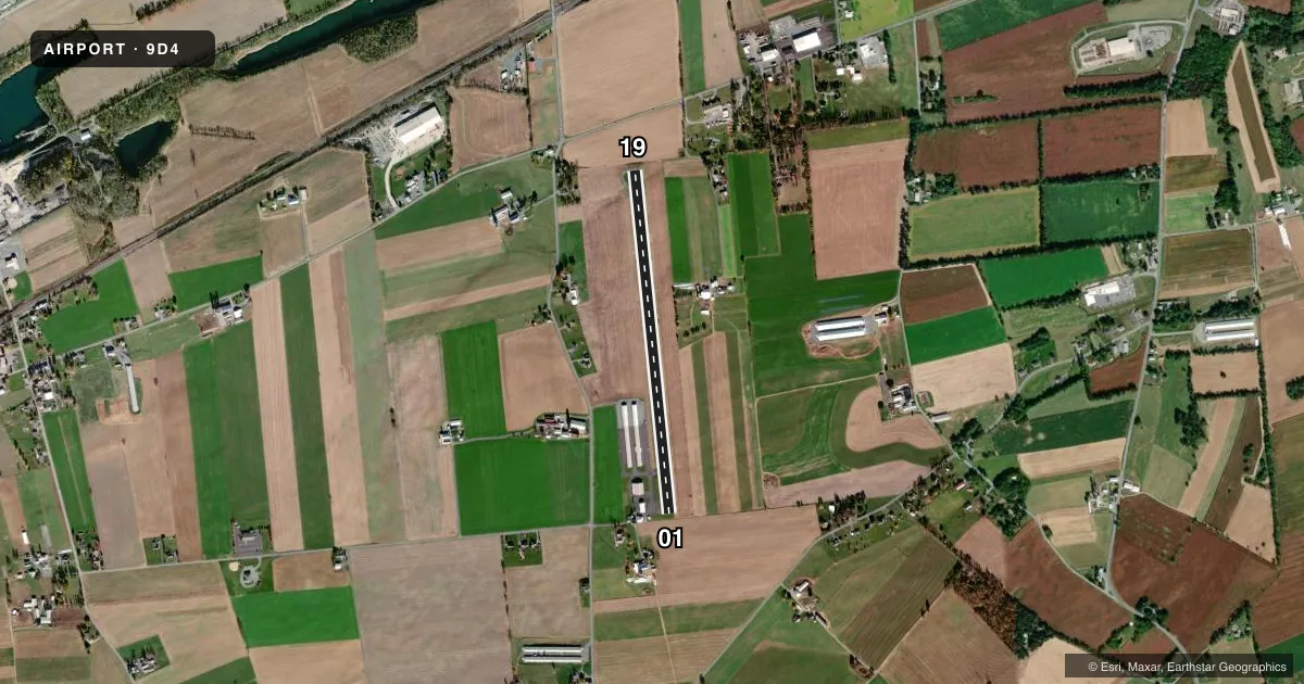
Runways & pattern
Full pagePattern entry · RWY 01
LEFT TRAFFICRunway end performance
| End | TORA | TODA | ASDA | LDA | VGSI | Approach lights | Obstruction |
|---|---|---|---|---|---|---|---|
| 01 | — | — | — | — | PAPI 2-box left(3°) | — | 34', bldg, 420' from thr, 243' R of cntrln, slope 6 |
| 19 | — | — | — | — | PAPI 2-box left(4°) | — | — |
Declared distances in feet. TORA = takeoff run available, TODA = takeoff distance, ASDA = accelerate-stop, LDA = landing distance.
Airport sketch
Runways drawn to scale from FAA survey coordinates, rendered over satellite imagery. Not for navigation.
Approaches & charts
Services on the field
Fuel grades, oxygen, maintenance, ramp storage and lighting — as declared to the FAA by the airport operator.
Fuel & services
- Fuel
- 100LLA
- Oxygen (bottled)
- High pressure
- Oxygen (bulk)
- High pressure
- Airframe repair
- Major
- Power plant repair
- Major
- Other services
- CHTR,RNTL
Ramp & ground
- Transient storage
- Tie-down
- Hangar
- Lighting schedule
- SEE RMK
- Beacon schedule
- SEE RMK
- Beacon
- White / Green (civil land)(WG)
- Wind indicator
- Lighted
- Segmented circle
- No
Fuel & FBOs
Cheapest 100LL and Jet A on the field and nearby. Always confirm with the FBO before taxi.
Airport notes
Surface conditions, obstructions, local procedures, lighting outages and other notes published with each FAA cycle.
General notes
- FOR CD CTC HARRISBURG APCH AT 800-932-0712.
- ACFT HGR 570 FT BEHIND RWY 01 THR & 212 FT LEFT. ACFT MAY BE PARKED 57 FT BEHIND RWY 01 THLD & 132 FT LEFT.
- RWY 01/19 TURN AROUND AREA AT DEP END OF RWY 01 LEFT SIDE.
- HOVERING BY LRG MIL HEL NA.
Lighting notes
- ACTVT ROTG BCN - CTAF.
- ACTVT REIL RWY 01 & 19; PAPI RWY 01 & 19; MIRL RWY 01/19 - CTAF.
Runway surface & condition
- 01/19NO AMBER CAUTION LGTS LAST HALF OF RWY.
Approach & departure obstructions
- 01FUEL TANK 22 FT OFF AER AND 208 FT L.
- 01NSTD REIL - STROBE LGTS IDENTIFY RWY ENDS.
- 19NSTD REIL - STROBE LGTS IDENTIFY RWY ENDS.
Other notes
- THIS AIRPORT HAS BEEN SURVEYED BY THE NATIONAL GEODETIC SURVEY.
- PRVDD VFR ONLY; AND DRIVEWAY SW OF RWY 36 IS EITHER CLOSED; RELOCATED; OR A MEANS IS ESTABLISHED TO CONTROL VEH TRAFFIC.
- MANAGER717-866-2184.
VFR map & nearby airports
VFR sectional. Tap any ICAO chip to open that airport.
Key facts · 9D4
Answer card- ICAO
- 9D4
- Name
- DECK
- Location
- MYERSTOWN, PENNSYLVANIA
- Elevation
- 523.3 ft MSL
- Traffic pattern altitude
- 1,523.3 ft MSL (1,000 AGL)
- Control tower
- Non-towered (use CTAF)
- Total runways
- 1
- Longest runway
- 01/19 · 3,786 ft
- Published ILS approaches
- 0
- Published frequencies
- 4
- Magnetic variation
- 9°
- Current flight rules
- VFR
- Current wind
- 300° at 5 kt
- Favored runway now
- RWY 01
DECK Airport is in Myerstown, Pennsylvania. Field elevation is 523.3 ft MSL. It has one runway, 01/19, which is 3,786 ft long. There is no control tower. Pattern altitude is not published, so use the standard 1,000 ft AGL for light piston traffic unless the current Chart Supplement says otherwise.
No ILS approaches are published here. The airport is set up for VFR use only. For clearance delivery, contact Harrisburg Approach. Published frequencies include CTAF and UNICOM on 122.8. Harrisburg Approach is on 118.25 and 269.45. Air Deck is on the field. It carries 100LL and Jet A. If you need fuel or ramp details, call them at (717) 866-6529 before arrival.
A few published remarks matter on a first visit. The rotating beacon operates on the CTAF frequency. Runway end identifier lights are installed on 01 and 19. PAPI is also available on both ends. There is a fuel tank 208 ft left of runway 01. The airport also notes that large military helicopter hovering is not authorized. This is a small non-towered field with one runway. Keep your scan tight on pattern traffic and use the published lighting and runway-end cues carefully at night.