METAR & TAF 74N
74N does not publish a METAR.
Showing the nearest reporting station: KZER (SCHUYLKILL COUNTY/JOE ZERBEY) · 12.3 NM away. Conditions at 74N may differ.
METAR · KZER
Observed 16:15Z
KZER 261615Z AUTO 00000KT 10SM BKN025 BKN031 OVC044 22/16 A2997 RMK AO2
- Wind
- 000° @ 0 kt
- Visibility
- 10 SM
- Temp / Dew
- 22°C / 16°C
- Altimeter
- 29.97 inHg
- Clouds
- OVC
- Density alt
- 1,758 ft
- Ceiling
- 2,500 ft AGL
- Rules
- MVFR
Airport info & contacts
Manager on record, flight service, ARTCC, attendance schedule and pattern altitude — published by the FAA and refreshed every 28 days.
Location
- From city
- 2 NM S
- VFR sectional
- NEW YORK
- ARTCC
- ZNY · NEW YORK
- NOTAM facility
- IPT (NOTAM-D)
Airport manager
- Name
- PAUL BENDIGO
- Phone
- 610-413-7428
- Address
- 250 DICKINSON DR., READING PA 17605
Flight service · Hours
- FSS IPT
- WILLIAMSPORT1-800-WX-BRIEF
- Attendance
- UNATTENDED · UNATTENDED
Frequencies
Tap any row to copy the frequency to your clipboard.
Runways & pattern
Full pagePattern entry · RWY 05
LEFT TRAFFICRunway end performance
| End | TORA | TODA | ASDA | LDA | VGSI | Approach lights | Obstruction |
|---|---|---|---|---|---|---|---|
| 05 | — | — | — | — | — | — | 34', trees, 710' from thr, 12' R of cntrln, slope 15 |
| 23 | — | — | — | — | VASI 2-box right(3°) | — | 23', tree, 441' from thr, 135' R of cntrln, slope 10 |
Declared distances in feet. TORA = takeoff run available, TODA = takeoff distance, ASDA = accelerate-stop, LDA = landing distance.
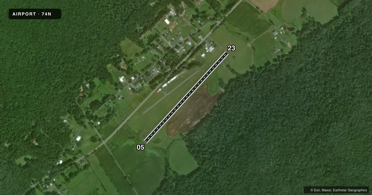
Airport sketch
Runways drawn to scale from FAA survey coordinates, rendered over satellite imagery. Not for navigation.
Approaches & charts
Services on the field
Fuel grades, oxygen, maintenance, ramp storage and lighting — as declared to the FAA by the airport operator.
Fuel & services
- Fuel
- Not available
- Oxygen (bottled)
- Not available
- Oxygen (bulk)
- Not available
Ramp & ground
- Transient storage
- Tie-down
- Landing fee
- No fee published
- Lighting schedule
- SEE RMK
- Beacon
- White / Green (civil land)(WG)
- Wind indicator
- Lighted
- Segmented circle
- No
Fuel & FBOs
Cheapest 100LL and Jet A on the field and nearby. Always confirm with the FBO before taxi.
Airport notes
Surface conditions, obstructions, local procedures, lighting outages and other notes published with each FAA cycle.
General notes
- 160 FT LGHTD TWR 400 FT N OF RWY MIDFIELD.
- RAPIDLY RISING TRRN 1500 MSL N-NW OF RWY 5. MT RIDGE 1500 MSL 1 NM S OF ARPT PARALLEL TO RWY 5/23.
- FOR CD CTC HARRISBURG APCH AT 800-932-0712.
- DEER AND WILDLIFE ON & INVOF ARPT.
Lighting notes
- ACTVT MIRL RWY 05/23 - CTAF.
Approach & departure obstructions
- 05CLSD DLY SS-SR.
- 23VASI OTS INDEFLY.
- 23APCH RATIO 28:1 TO DTHR.
Other notes
- BUILT BEFORE 1959.
VFR map & nearby airports
VFR sectional. Tap any ICAO chip to open that airport.
Key facts · 74N
Answer card- ICAO
- 74N
- Name
- BENDIGO
- Location
- TOWER CITY, PENNSYLVANIA
- Elevation
- 790.6 ft MSL
- Traffic pattern altitude
- 1,790.6 ft MSL (1,000 AGL)
- Control tower
- Non-towered (use CTAF)
- Total runways
- 1
- Longest runway
- 05/23 · 2,325 ft
- Published ILS approaches
- 0
- Published frequencies
- 3
- Magnetic variation
- 11°
- Current flight rules
- MVFR
- Current wind
- 000° at 0 kt
- Favored runway now
- –
Bendigo (74N) is in Tower City, Pennsylvania. The field elevation is 790.6 ft MSL. It has one runway. Runway 05/23 is 2,325 ft long with asphalt-concrete pavement. There is no control tower. Clearance delivery goes through Harrisburg Approach at 800-932-0712.
No ILS approaches are published here. Pattern altitude is not published, so use the standard 1,000 ft AGL for light piston traffic unless the current Chart Supplement says otherwise. The runway lights on 05/23 are medium intensity and are activated by CTAF. Runway 05 is closed daily from sunset to sunrise. The VASI on runway 23 is out of service indefinitely. There is also a 160-foot lighted tower about 400 feet north of the runway midfield.
There are no on-field FBOs listed. Check with the airport operator or the FBO directly by phone before you go. Wildlife is a real factor here. Deer have been reported on and near the airport. Terrain also matters. A ridge sits about 1 nautical mile south of the airport, parallel to runway 05/23. Rising terrain is also reported north-northwest of runway 05. Plan your arrival with that in mind, especially if you are arriving low or at night.