METAR & TAF 69N
69N does not publish a METAR.
Showing the nearest reporting station: KABE (LEHIGH VALLEY INTL) · 10.0 NM away. Conditions at 69N may differ.
METAR · KABE
Observed 12:51Z
KABE 271251Z 30003KT 10SM CLR 23/19 A2985 RMK AO2 SLP106 T02280189 $
- Wind
- 300° @ 3 kt
- Visibility
- 10 SM
- Temp / Dew
- 23°C / 19°C
- Altimeter
- 29.85 inHg
- Clouds
- CLR
- Density alt
- 1,518 ft
- Ceiling
- Unlimited
- Rules
- VFR
Airport info & contacts
Manager on record, flight service, ARTCC, attendance schedule and pattern altitude — published by the FAA and refreshed every 28 days.
Location
- From city
- 1 NM N
- VFR sectional
- NEW YORK
- ARTCC
- ZNY · NEW YORK
- NOTAM facility
- IPT (NOTAM-D)
Airport manager
- Name
- ROGER S. SELL
- Phone
- 610-767-5881
- Address
- 1000 AIRPORT LANE, SLATINGTON PA 18080
Flight service · Hours
- FSS IPT
- WILLIAMSPORT1-800-WX-BRIEF
- Attendance
- MON-SAT · DALGT
Frequencies
Tap any row to copy the frequency to your clipboard.
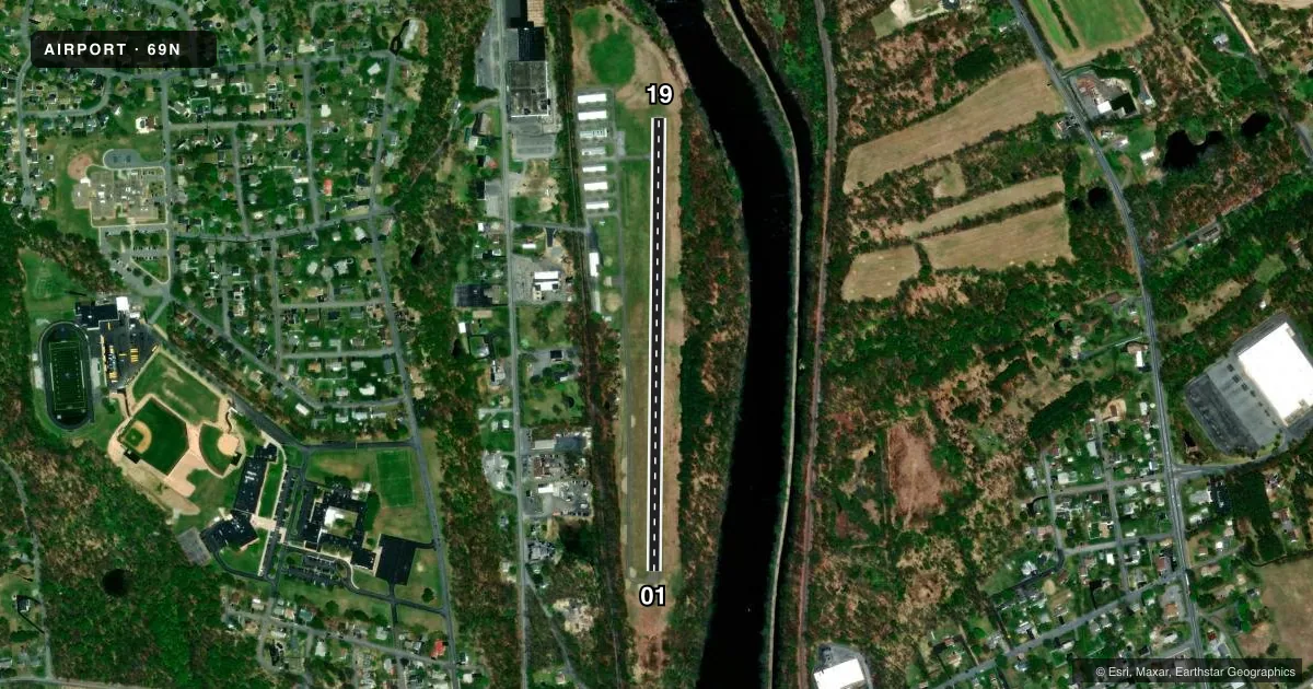
Runways & pattern
Full pagePattern entry · RWY 01
LEFT TRAFFICRunway end performance
| End | TORA | TODA | ASDA | LDA | VGSI | Approach lights | Obstruction |
|---|---|---|---|---|---|---|---|
| 01 | — | — | — | — | — | — | 43', trees, 546' from thr, 96' R of cntrln, slope 8 |
| 19 | — | — | — | — | — | — | 63', trees, 815' from thr, 158' R of cntrln, slope 9 |
Declared distances in feet. TORA = takeoff run available, TODA = takeoff distance, ASDA = accelerate-stop, LDA = landing distance.
Airport sketch
Runways drawn to scale from FAA survey coordinates, rendered over satellite imagery. Not for navigation.
Approaches & charts
Services on the field
Fuel grades, oxygen, maintenance, ramp storage and lighting — as declared to the FAA by the airport operator.
Fuel & services
- Fuel
- 100LL
- Oxygen (bottled)
- Not available
- Oxygen (bulk)
- Not available
- Airframe repair
- Major
- Power plant repair
- Major
- Other services
- INSTR,RNTL
Ramp & ground
- Transient storage
- Tie-down
- Landing fee
- No fee published
- Customs
- Not available
- Lighting schedule
- SEE RMK
- Beacon schedule
- SEE RMK
- Beacon
- White / Green (civil land)(WG)
- Wind indicator
- Lighted
- Segmented circle
- Yes
Fuel & FBOs
Cheapest 100LL and Jet A on the field and nearby. Always confirm with the FBO before taxi.
Airport notes
Surface conditions, obstructions, local procedures, lighting outages and other notes published with each FAA cycle.
General notes
- +977 FT HILL 7700 FT FROM RWY 19 THLD.
- FOR CD CTC ALLENTOWN APCH AT 800-728-6322.
- FOR SVC AFTR HRS CALL 610-799-3302.
- RWY 01/19 CLSD TO TSNT ACFT SS-SR.
Lighting notes
- ACTVT ROTG BCN - CTAF.
- ACTVT LIRL RWY 01/19 - CTAF.
Runway surface & condition
- 01/19NON STANDARD LIRL LOCATED 10 FT OUTBOARD FM RWY EDGES. RWY 19 END LGTS LOCATED OUTBOARD FROM RWY EDGES.
Approach & departure obstructions
- 01APCH SLP 15:1 TO DTHR.
Other notes
- EXISTED PRIOR TO 1959.
VFR map & nearby airports
VFR sectional. Tap any ICAO chip to open that airport.
Key facts · 69N
Answer card- ICAO
- 69N
- Name
- SLATINGTON
- Location
- SLATINGTON, PENNSYLVANIA
- Elevation
- 380 ft MSL
- Traffic pattern altitude
- 1,380 ft MSL (1,000 AGL)
- Control tower
- Non-towered (use CTAF)
- Total runways
- 1
- Longest runway
- 01/19 · 2,455 ft
- Published ILS approaches
- 0
- Published frequencies
- 2
- Magnetic variation
- 11°
- Current flight rules
- VFR
- Current wind
- 300° at 3 kt
- Favored runway now
- RWY 01
Slatington Airport is in Slatington, Pennsylvania. Field elevation is 380 ft MSL. It has one runway. Runway 01/19 is 2,455 ft of asphalt, so plan performance with that length in mind. There is no control tower. CTAF and UNICOM are both 122.8.
No ILS approaches are published here. Pattern altitude is not published in the facts, so verify the current Chart Supplement before you fly the pattern. The airport uses CTAF for runway lights and the rotating beacon. The published remarks also note that runway 01/19 is closed to transient aircraft from sunset to sunrise. That matters for any late arrival or overnight plan.
Roger Sell is the on-field FBO. It carries 100LL. For after-hours service, the published number is 610-799-3302. There is also a 977-foot hill 7,700 feet from the runway 19 threshold. The approach slope to the displaced threshold on runway 01 is 15 to 1. That is worth a careful look on arrival, especially if you are coming in low or at night. For clearance delivery, contact Allentown Approach at 800-728-6322.