METAR & TAF N94
N94 does not publish a METAR.
Showing the nearest reporting station: KCXY (CAPITAL CITY) · 14.9 NM away. Conditions at N94 may differ.
METAR · KCXY
Observed 15:56Z
KCXY 271556Z 35008KT 300V020 10SM CLR 28/17 A2986 RMK AO2 SLP108 T02830167
- Wind
- 350° @ 8 kt
- Visibility
- 10 SM
- Temp / Dew
- 28°C / 17°C
- Altimeter
- 29.86 inHg
- Clouds
- CLR
- Density alt
- 2,267 ft
- Ceiling
- Unlimited
- Rules
- VFR
Airport info & contacts
Manager on record, flight service, ARTCC, attendance schedule and pattern altitude — published by the FAA and refreshed every 28 days.
Location
- From city
- 2 NM SE
- VFR sectional
- DETROIT
- ARTCC
- ZNY · NEW YORK
- NOTAM facility
- IPT (NOTAM-D)
Airport manager
- Name
- JEFF SMITH
- Phone
- 717-448-7730
- Address
- 228 PETERSBURG RD, CARLISLE PA 17013
Flight service · Hours
- FSS IPT
- WILLIAMSPORT1-800-WX-BRIEF
- Attendance
- MON-FRI · 0700-1500
- SAT-SUN · IRREGULAR
Frequencies
Tap any row to copy the frequency to your clipboard.
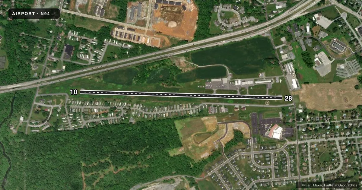
Runways & pattern
Full pagePattern entry · RWY 28
LEFT TRAFFICAirport sketch
Runways drawn to scale from FAA survey coordinates, rendered over satellite imagery. Not for navigation.
Approaches & charts
Services on the field
Fuel grades, oxygen, maintenance, ramp storage and lighting — as declared to the FAA by the airport operator.
Fuel & services
- Fuel
- 100LLA+
- Oxygen (bottled)
- Not available
- Oxygen (bulk)
- Not available
- Airframe repair
- Minor
- Power plant repair
- Minor
Ramp & ground
- Transient storage
- Tie-down
- Landing fee
- No fee published
- Customs
- Not available
- Lighting schedule
- SEE RMK
- Beacon schedule
- SS-SR
- Beacon
- White / Green (civil land)(WG)
- Wind indicator
- Lighted
- Segmented circle
- Yes
Fuel & FBOs
Cheapest 100LL and Jet A on the field and nearby. Always confirm with the FBO before taxi.
Airport notes
Surface conditions, obstructions, local procedures, lighting outages and other notes published with each FAA cycle.
General notes
- DEER AND BIRDS ON & INVOF ARPT. LRG BIRD ACT INCREASED .5 NM W APCH END RWY 10.
- DURG NGT OPS TRAILER PARK LGTS LCTD S OF RWY COULD BE MISTAKEN FOR RWY LGTS.
- FOR CD CTC HARRISBURG APCH AT 800-932-0712.
Lighting notes
- ACTVT LIRL RWY 10/28 - CTAF.
Approach & departure obstructions
- 28RWY 28 HAS 17 FT ROAD 185 FT FM RWY END ACRS CNTRLN.
VFR map & nearby airports
VFR sectional. Tap any ICAO chip to open that airport.
Key facts · N94
Answer card- ICAO
- N94
- Name
- CARLISLE
- Location
- CARLISLE, PENNSYLVANIA
- Elevation
- 510.1 ft MSL
- Traffic pattern altitude
- 1,510.1 ft MSL (1,000 AGL)
- Control tower
- Non-towered (use CTAF)
- Total runways
- 1
- Longest runway
- 10/28 · 4,008 ft
- Published ILS approaches
- 0
- Published frequencies
- 4
- Magnetic variation
- 10°
- Current flight rules
- VFR
- Current wind
- 350° at 8 kt
- Favored runway now
- RWY 28
Carlisle Airport (N94) is in Carlisle, Pennsylvania. The field elevation is 510.1 ft MSL. It has one runway, 10/28, which is 4,008 ft long and paved asphalt. There is no control tower. Traffic pattern altitude is not published, so use the standard 1,000 ft AGL pattern for light piston operations unless the current Chart Supplement says otherwise.
No ILS approaches are published here. IFR pilots should plan to work Harrisburg Approach on 124.1 or 273.525 for approach and departure services. For clearance delivery, contact Harrisburg Approach at 800-932-0712. The on-field FBO is Carlisle Airport. It carries 100LL and Jet A Prist.
A few local items matter here. Runway 10/28 uses low-intensity lights that are activated by the CTAF. On runway 28, there is a 17-foot road 185 feet from the runway end across the centerline. At night, trailer park lights south of the runway can be mistaken for runway lighting. Deer and birds are reported on and near the field. Large bird activity has increased about half a nautical mile west of the approach end of runway 10. If you are new to the airport, brief the lighting cues and the wildlife picture before arrival.