METAR & TAF N68
N68 does not publish a METAR.
Showing the nearest reporting station: KHGR (HAGERSTOWN RGNL/RICHARD A HENSON FLD) · 16.3 NM away. Conditions at N68 may differ.
METAR · KHGR
Observed 15:53Z
KHGR 261553Z VRB04KT 10SM SCT028 26/16 A2993 RMK AO2 SLP139 T02560161 $
- Wind
- VAR @ 4 kt
- Visibility
- 10 SM
- Temp / Dew
- 26°C / 16°C
- Altimeter
- 29.93 inHg
- Clouds
- SCT
- Density alt
- 2,160 ft
- Ceiling
- Unlimited
- Rules
- VFR
Airport info & contacts
Manager on record, flight service, ARTCC, attendance schedule and pattern altitude — published by the FAA and refreshed every 28 days.
Location
- From city
- 3 NM N
- VFR sectional
- WASHINGTON
- ARTCC
- ZNY · NEW YORK
- NOTAM facility
- IPT (NOTAM-D)
Airport manager
- Name
- TIM EDWARDS
- Phone
- 717-948-3900
- Address
- ONE TERMINAL DRIVE, SUITE 300, 208 AIRPORT DRIVE, MIDDLETOWN PA 17057
Flight service · Hours
- FSS IPT
- WILLIAMSPORT1-800-WX-BRIEF
- Attendance
- UNATTND
Frequencies
Tap any row to copy the frequency to your clipboard.
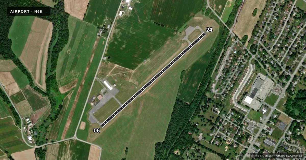
Runways & pattern
Full pagePattern entry · RWY 06
LEFT TRAFFICRunway end performance
| End | TORA | TODA | ASDA | LDA | VGSI | Approach lights | Obstruction |
|---|---|---|---|---|---|---|---|
| 06 | — | — | — | — | PAPI 2-box right(3°) | — | — |
| 24 | — | — | — | — | PAPI 2-box left(3°) | — | 47', trees, 414' from thr, 249' R of cntrln, slope 4 |
Declared distances in feet. TORA = takeoff run available, TODA = takeoff distance, ASDA = accelerate-stop, LDA = landing distance.
Airport sketch
Runways drawn to scale from FAA survey coordinates, rendered over satellite imagery. Not for navigation.
Approaches & charts
Services on the field
Fuel grades, oxygen, maintenance, ramp storage and lighting — as declared to the FAA by the airport operator.
Fuel & services
- Fuel
- 100LL
- Oxygen (bulk)
- Not available
- Airframe repair
- Minor
- Power plant repair
- Minor
Ramp & ground
- Transient storage
- Tie-down
- Landing fee
- No fee published
- Customs
- Not available
- Lighting schedule
- SEE RMK
- Beacon schedule
- SS-SR
- Beacon
- White / Green (civil land)(WG)
- Wind indicator
- Lighted
- Segmented circle
- Yes
Fuel & FBOs
Cheapest 100LL and Jet A on the field and nearby. Always confirm with the FBO before taxi.
Airport notes
Surface conditions, obstructions, local procedures, lighting outages and other notes published with each FAA cycle.
General notes
- FOR CD CTC HARRISBURG APCH AT 800-932-0712.
Lighting notes
- ACTVT MIRL RWY 06/24 - CTAF.
Other notes
- OWNER717-774-8335 OR 717-948-3501.
VFR map & nearby airports
VFR sectional. Tap any ICAO chip to open that airport.
Key facts · N68
Answer card- ICAO
- N68
- Name
- FRANKLIN COUNTY RGNL
- Location
- CHAMBERSBURG, PENNSYLVANIA
- Elevation
- 687.8 ft MSL
- Traffic pattern altitude
- 1,687.8 ft MSL (1,000 AGL)
- Control tower
- Non-towered (use CTAF)
- Total runways
- 1
- Longest runway
- 06/24 · 3,300 ft
- Published ILS approaches
- 0
- Published frequencies
- 3
- Magnetic variation
- 11°
- Current flight rules
- VFR
- Current wind
- 000° at 4 kt
- Favored runway now
- RWY 06
Franklin County Rgnl Airport (N68) sits in Chambersburg, Pennsylvania. Field elevation is 687.8 ft MSL. The airport has one runway. Runway 06/24 is 3,300 ft long and asphalt. The field is not towered. Traffic pattern altitude is not published, so use the standard 1,000 ft AGL for light piston traffic unless the current Chart Supplement says otherwise.
No ILS approaches are published here. For IFR work, plan with the current approach chart set before you go. The published remarks also note that the medium intensity runway lights on 06/24 are activated by CTAF. That is useful after sunset or if you are arriving late. For clearance delivery, Harrisburg Approach is the published contact point. The airport owner contact is also listed in the Chart Supplement.
For a first-time pilot, the main things to know are simple. This is an uncontrolled field with one short-to-medium asphalt runway. Expect normal non-towered traffic flow on CTAF 122.9. Check the current Chart Supplement for any noise or curfew restrictions before flying into the field. If you are planning an IFR arrival or departure, verify the current procedures and coordination details before launch.