METAR & TAF P17
P17 does not publish a METAR.
Showing the nearest reporting station: KHMZ (BEDFORD COUNTY) · 16.1 NM away. Conditions at P17 may differ.
METAR · KHMZ
Observed 17:15Z
KHMZ 271715Z AUTO 32010KT 10SM SCT045 SCT050 BKN065 28/17 A2989 RMK AO2 T02800166
- Wind
- 320° @ 10 kt
- Visibility
- 10 SM
- Temp / Dew
- 28°C / 17°C
- Altimeter
- 29.89 inHg
- Clouds
- BKN
- Density alt
- 3,265 ft
- Ceiling
- 6,500 ft AGL
- Rules
- VFR
Airport info & contacts
Manager on record, flight service, ARTCC, attendance schedule and pattern altitude — published by the FAA and refreshed every 28 days.
Location
- From city
- 7 NM S
- VFR sectional
- CINCINNATI
- ARTCC
- ZOB · CLEVELAND
- NOTAM facility
- AOO
Airport manager
- Name
- RICHARD ACKLEY
- Phone
- 814-327-8287
- Address
- 814 ALLEN RD, CLEARVILLE PA 15535
Flight service · Hours
- FSS AOO
- ALTOONA1-800-WX-BRIEF
Frequencies
Tap any row to copy the frequency to your clipboard.
Runways & pattern
Full pagePattern entry · RWY 03
RIGHT TRAFFICRunway end performance
| End | TORA | TODA | ASDA | LDA | VGSI | Approach lights | Obstruction |
|---|---|---|---|---|---|---|---|
| 21 | — | — | — | — | — | — | 30', tree, 123' from thr, 47' R of cntrln, slope 4 |
Declared distances in feet. TORA = takeoff run available, TODA = takeoff distance, ASDA = accelerate-stop, LDA = landing distance.
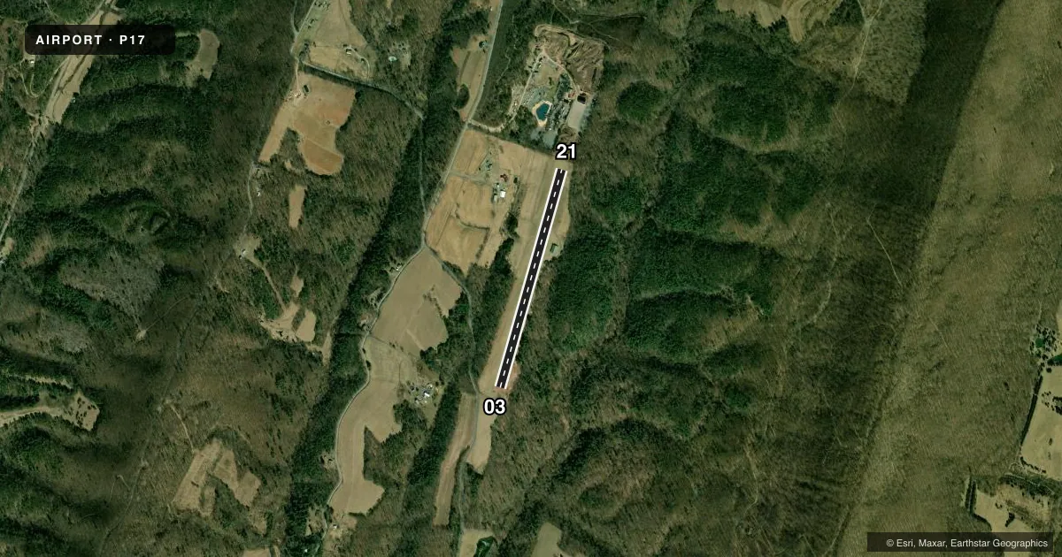
Airport sketch
Runways drawn to scale from FAA survey coordinates, rendered over satellite imagery. Not for navigation.
Approaches & charts
Services on the field
Fuel grades, oxygen, maintenance, ramp storage and lighting — as declared to the FAA by the airport operator.
Fuel & services
- Fuel
- Not available
- Oxygen (bottled)
- Not available
- Oxygen (bulk)
- Not available
- Airframe repair
- Not available
- Power plant repair
- Not available
- Other services
- GLD,TOW
Ramp & ground
- Transient storage
- Hangar
- Wind indicator
- Yes
- Segmented circle
- No
Fuel & FBOs
Cheapest 100LL and Jet A on the field and nearby. Always confirm with the FBO before taxi.
Airport notes
Surface conditions, obstructions, local procedures, lighting outages and other notes published with each FAA cycle.
General notes
- GLDR TOWING AND ACTVTY ON ARPT.
- RWY MKD WITH W PLASTIC BARRELS.
- DEER AND WILDLIFE ON & INVOF ARPT, LOW PASS ENCOURAGED.
- CALL MAIN NR FOR FICONS.
- FOR CD CTC JOHNSTOWN APCH AT 814-532-5960, WHEN APCH CLSD CTC CLEVELAND ARTCC AT 440-774-0213.
- RWY 3 PREFERRED FOR LNDG. RWY 21 PREFERRED FOR TKOF.
- LOW PER OR LOW PWRD ACFT MUST TKOF ON RWY 21.
Approach & departure obstructions
- 21RWY 21 APCH SLP 22:1 TO DTHR.
Other notes
- OPR HRS 0600-2000.
VFR map & nearby airports
VFR sectional. Tap any ICAO chip to open that airport.
Key facts · P17
Answer card- ICAO
- P17
- Name
- GREATER BREEZEWOOD RGNL
- Location
- BREEZEWOOD, PENNSYLVANIA
- Elevation
- 1,345 ft MSL
- Traffic pattern altitude
- 2,345 ft MSL (1,000 AGL)
- Control tower
- Non-towered (use CTAF)
- Total runways
- 1
- Longest runway
- 03/21 · 3,073 ft
- Published ILS approaches
- 0
- Published frequencies
- 1
- Magnetic variation
- –
- Current flight rules
- VFR
- Current wind
- 320° at 10 kt
- Favored runway now
- RWY 03
Greater Breezewood RGNL (P17) sits in Breezewood, Pennsylvania. Field elevation is 1,345 ft MSL. The airport has one runway. Runway 03/21 is 3,073 ft of turf, with magnetic headings 16° and 196°. No ILS approaches are published here. The field is not towered. Operating hours are 0600 to 2000. CTAF is 122.9.
For pattern work, the published pattern altitude is not given. Use the standard 1,000 ft AGL pattern for light piston aircraft unless the current Chart Supplement or airport operator says otherwise. Runway 3 is preferred for landing. Runway 21 is preferred for takeoff. Low performance or low powered aircraft must take off on Runway 21. The runway is marked with white plastic barrels. Deer and other wildlife are reported on and near the airport, so keep a sharp scan on short final and in the pattern. Glider towing and glider activity also occur here.
No on-field FBOs are listed in the facts. Contact the airport operator directly before arrival, or call the field on CTAF for current FBO availability. For clearance delivery, contact Johnstown Approach at 814-532-5960. When approach is closed, contact Cleveland ARTCC at 440-774-0213.