METAR & TAF KHMZ
Current METAR
Observed 17:15Z
KHMZ 271715Z AUTO 32010KT 10SM SCT045 SCT050 BKN065 28/17 A2989 RMK AO2 T02800166
- Wind
- 320° @ 10 kt
- Visibility
- 10 SM
- Temp / Dew
- 28°C / 17°C
- Altimeter
- 29.89 inHg
- Clouds
- BKN
- Density alt
- 3,038 ft
- Ceiling
- 6,500 ft AGL
- Rules
- VFR
Airport info & contacts
Manager on record, flight service, ARTCC, attendance schedule and pattern altitude — published by the FAA and refreshed every 28 days.
Location
- From city
- 4 NM N
- VFR sectional
- WASHINGTON
- ARTCC
- ZOB · CLEVELAND
- NOTAM facility
- AOO (NOTAM-D)
Airport manager
- Name
- JIM VEACH
- Phone
- 814-623-0704
- Address
- 227 AIRPORT RD, BEDFORD PA 15522
Flight service · Hours
- FSS AOO
- ALTOONA1-800-WX-BRIEF
- Attendance
- MON-FRI · 0800-1630
- SAT · 0800-1630
- SUN · 0800-1630
Frequencies
Tap any row to copy the frequency to your clipboard.
Runways & pattern
Full pagePattern entry · RWY 32
LEFT TRAFFICRunway end performance
| End | TORA | TODA | ASDA | LDA | VGSI | Approach lights | Obstruction |
|---|---|---|---|---|---|---|---|
| 14 | — | — | — | — | PAPI 2-box right(3°) | — | — |
| 32 | — | — | — | — | PAPI 2-box left(4°) | — | 17', trees, 671' from thr, 284' R of cntrln, slope 27 |
Declared distances in feet. TORA = takeoff run available, TODA = takeoff distance, ASDA = accelerate-stop, LDA = landing distance.
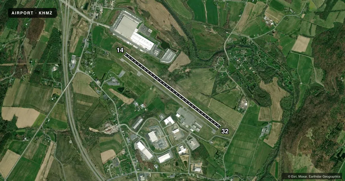
Airport sketch
Runways drawn to scale from FAA survey coordinates, rendered over satellite imagery. Not for navigation.
Approaches & charts
Services on the field
Fuel grades, oxygen, maintenance, ramp storage and lighting — as declared to the FAA by the airport operator.
Fuel & services
- Fuel
- 100LLA
- Oxygen (bulk)
- High pressure
- Airframe repair
- Major
- Power plant repair
- Major
- Other services
- AVNCS,CHTR,GLD,INSTR,RNTL,SALES
Ramp & ground
- Transient storage
- Tie-down
- Hangar
- Landing fee
- Yes
- Lighting schedule
- SEE RMK
- Beacon schedule
- SS-SR
- Beacon
- White / Green (civil land)(WG)
- Wind indicator
- Lighted
- Segmented circle
- Yes
Fuel & FBOs
Cheapest 100LL and Jet A on the field and nearby. Always confirm with the FBO before taxi.
Airport notes
Surface conditions, obstructions, local procedures, lighting outages and other notes published with each FAA cycle.
General notes
- HIGH TERRAIN (MTN RIDGES) SOUTHEAST OF ARPT LGTD WITH RED OBSTRUCTION LGTS.
- FOR CD CTC JOHNSTOWN APCH AT 814-532-5960, WHEN APCH CLSD CTC CLEVELAND ARTCC AT 440-774-0213.
Lighting notes
- ACTVT MIRL RWY 14/32; REIL RWY 14 & 32 - CTAF. PAPI RWY 14 & 32 OPR CONSLY. REIL ACTVT ONLY WITH 3, 5, OR 7 CLICKS.
Other notes
- LANDING FEE FOR ALL ACFT EXCEPT LIGHT SINGLE ENGINE WITH FUEL PURCHASE.
- 2FOR SVC AFTER HRS CNT 814-494-0929
VFR map & nearby airports
VFR sectional. Tap any ICAO chip to open that airport.
Key facts · KHMZ
Answer card- ICAO
- KHMZ
- Name
- BEDFORD COUNTY
- Location
- BEDFORD, PENNSYLVANIA
- Elevation
- 1,161.7 ft MSL
- Traffic pattern altitude
- 2,161.7 ft MSL (1,000 AGL)
- Control tower
- Non-towered (use CTAF)
- Total runways
- 1
- Longest runway
- 14/32 · 5,006 ft
- Published ILS approaches
- 0
- Published frequencies
- 4
- Magnetic variation
- 9°
- Current flight rules
- VFR
- Current wind
- 320° at 10 kt
- Favored runway now
- RWY 32
Bedford County Airport sits in Bedford, Pennsylvania. Field elevation is 1,161.7 ft MSL. The airport has one runway. Runway 14/32 is 5,006 ft long with an asphalt surface. There is no control tower. Traffic pattern altitude is not published. Use the standard 1,000 ft AGL pattern for light piston operations unless the current Chart Supplement says otherwise.
No ILS approaches are published here. Johnstown Approach handles clearance delivery and approach services. CTAF and UNICOM are both 122.7. The runway lighting is pilot controlled on CTAF. Medium intensity runway lights are installed on 14/32. REIL is available on both ends. PAPI operates continuously on both runway ends. The field also sits near high terrain. Mountain ridges lie southeast of the airport. They are lighted with red obstruction lights. Plan your arrival and departure paths with that in mind.
Bun Air is on the field. It carries 100LL, Jet A and Jet A Prist. There is a landing fee for all aircraft except light single-engine aircraft with a fuel purchase. For service after hours, call 814-494-0929. If you need a clearance and Johnstown Approach is closed, contact Cleveland ARTCC. For a first-time arrival, expect a non-towered field with terrain nearby. Make your radio work early.