METAR & TAF 2G9
Current METAR
Observed 18:35Z
K2G9 271835Z AUTO 30005KT 10SM SCT034 SCT050 25/17 A2993 RMK AO2
- Wind
- 300° @ 5 kt
- Visibility
- 10 SM
- Temp / Dew
- 25°C / 17°C
- Altimeter
- 29.93 inHg
- Clouds
- SCT
- Density alt
- 4,009 ft
- Ceiling
- Unlimited
- Rules
- VFR
Airport info & contacts
Manager on record, flight service, ARTCC, attendance schedule and pattern altitude — published by the FAA and refreshed every 28 days.
Location
- From city
- 3 NM NE
- VFR sectional
- DETROIT
- ARTCC
- ZOB · CLEVELAND
- NOTAM facility
- AOO (NOTAM-D)
Airport manager
- Name
- DAVID WRIGHT
- Phone
- 814-445-1599
- Address
- 159 AIRPORT LANE, FRIEDENS PA 15541
Flight service · Hours
- FSS AOO
- ALTOONA1-800-WX-BRIEF
- Attendance
- 0800-1600*
Frequencies
Tap any row to copy the frequency to your clipboard.
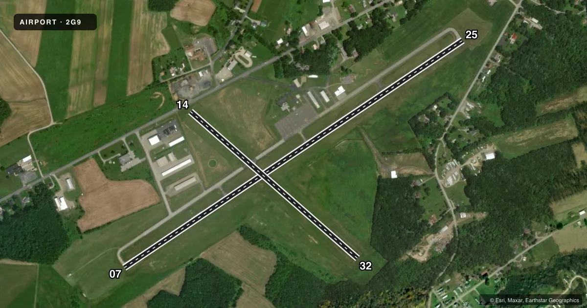
Runways & pattern
Full pagePattern entry · RWY 32
LEFT TRAFFIC| Runway | Heading (°M) | Length | Surface | Traffic |
|---|---|---|---|---|
| 07/25 | 46° / 226° | 5,002 ft | ASPH | Standard L |
| 14/32Favored | 121° / 301° | 2,729 ft | TURF | Standard L |
Runway end performance
| End | TORA | TODA | ASDA | LDA | VGSI | Approach lights | Obstruction |
|---|---|---|---|---|---|---|---|
| 07 | — | — | — | — | PAPI 2-box left(3°) | — | — |
| 25 | — | — | — | — | PSIL(3°) | — | 18', pole, 544' from thr, 180' R of cntrln, slope 19 |
| 14 | — | — | — | — | — | — | 16', road, 40' from thr, 124' R of cntrln, slope 2 |
| 32 | — | — | — | — | — | — | 26', trees, 352' from thr, 74' R of cntrln, slope 13 |
Declared distances in feet. TORA = takeoff run available, TODA = takeoff distance, ASDA = accelerate-stop, LDA = landing distance.
Airport sketch
Runways drawn to scale from FAA survey coordinates, rendered over satellite imagery. Not for navigation.
Approaches & charts
ILS · 1
Services on the field
Fuel grades, oxygen, maintenance, ramp storage and lighting — as declared to the FAA by the airport operator.
Fuel & services
- Fuel
- 100LLAA+
- Oxygen (bottled)
- Not available
- Oxygen (bulk)
- Not available
- Airframe repair
- Not available
- Power plant repair
- Not available
Ramp & ground
- Transient storage
- Tie-down
- Hangar
- Landing fee
- No fee published
- Customs
- Not available
- Lighting schedule
- SEE RMK
- Beacon schedule
- SS-SR
- Beacon
- White / Green (civil land)(WG)
- Wind indicator
- Lighted
- Segmented circle
- Yes
Fuel & FBOs
Cheapest 100LL and Jet A on the field and nearby. Always confirm with the FBO before taxi.
Airport notes
Surface conditions, obstructions, local procedures, lighting outages and other notes published with each FAA cycle.
General notes
- FOR CD CTC JOHNSTOWN APCH AT 814-532-5960, WHEN APCH CLSD CTC CLEVELAND ARTCC AT 440-774-0213.
- RWY 14/32 UNUSBL DURING SPRING THAW, WET PERIODS & SNOW; CHECK NOTAMS.
Lighting notes
- MIRL RWY 07/25 & TWY LGTS ON DUSK-0000; ACTVT REIL RWY 07/25, PAPI RWY 07; PVASI RWY 25; - CTAF.
Fuel notes
- 100LL24 HR SELF-SERVICE FUELING AVBL.
- ASINGLE POINT REFUELING AVBL UPON REQUEST.
Runway surface & condition
- 14/32617 FT BY 60 FT ASPH AT INTXN WITH RWY 07/25 & PARL TWY.
Approach & departure obstructions
- 14335 FT DTHR MKD WITH YELLOW CONES.
- 14YELLOW CONES
- 32YELLOW CONES
- 1441 FT TREES; 578 FT FM DER, 9 FT LEFT. APCH SLP 22:1 FM DTHR.
- 14ROAD ANGLES ACRS RCL.
Other notes
- 1UNATNDD NEW YEARS DAY, EASTER, THANKSGIVING, DAY AFT THANKSGIVING, CHRISTMAS DAY AND ALL FEDERAL HOLS.
VFR map & nearby airports
VFR sectional. Tap any ICAO chip to open that airport.
Key facts · 2G9
Answer card- ICAO
- 2G9
- Name
- SOMERSET COUNTY
- Location
- SOMERSET, PENNSYLVANIA
- Elevation
- 2,275 ft MSL
- Traffic pattern altitude
- 3,275 ft MSL (1,000 AGL)
- Control tower
- Non-towered (use CTAF)
- Total runways
- 2
- Longest runway
- 07/25 · 5,002 ft
- Published ILS approaches
- 1
- Published frequencies
- 4
- Magnetic variation
- 10°
- Current flight rules
- VFR
- Current wind
- 300° at 5 kt
- Favored runway now
- RWY 32
Somerset County Airport sits in Somerset, Pennsylvania. The field elevation is 2,275 ft MSL. It has two runways. The longest is 07/25 at 5,002 ft asphalt. Runway 14/32 is 2,729 ft turf. There is no control tower. CTAF and UNICOM are both 122.8. Johnstown Approach handles clearance delivery and approach control. The published ILS is for runway 25.
Pattern altitude is not published. Use 1,000 ft AGL for light piston traffic unless the current Chart Supplement says otherwise. That puts the pattern at 3,275 ft MSL based on the field elevation. The airport sits in the Somerset area of Pennsylvania at a fairly high elevation, so expect performance to matter on warm days. Runway 14/32 has several operational notes. Runway 14 has a displaced threshold marked with yellow cones. The runway is also reported unusable during spring thaw, wet periods and snow. A road angles across the runway centerline. The airport is unattended on major holidays and federal holidays. Somerset County Airport is the on-field FBO. It carries 100LL, Jet A and Jet A Prist. Twenty-four hour self-serve fuel is available. Single-point refueling is available on request.