METAR & TAF KCBE
Current METAR
Observed 17:15Z
KCBE 271715Z AUTO 28005KT 10SM BKN049 SCT055 SCT065 29/18 A2992 RMK AO2 T02900177
- Wind
- 280° @ 5 kt
- Visibility
- 10 SM
- Temp / Dew
- 29°C / 18°C
- Altimeter
- 29.92 inHg
- Clouds
- BKN
- Density alt
- 2,620 ft
- Ceiling
- 4,900 ft AGL
- Rules
- VFR
Airport info & contacts
Manager on record, flight service, ARTCC, attendance schedule and pattern altitude — published by the FAA and refreshed every 28 days.
Location
- From city
- 2 NM S
- VFR sectional
- WASHINGTON
- Pattern altitude
- 1,024 ft AGL · 1,782 ft MSL
- ARTCC
- ZOB · CLEVELAND
- NOTAM facility
- EKN (NOTAM-D)
Airport manager
- Name
- HAROLD KELLEY
- Phone
- 304-738-0002
- Address
- 165 TERMINAL LOOP, WILEY FORD WV 26767
Flight service · Hours
- FSS EKN
- ELKINS703-724-42881-800-WX-BRIEF
- Attendance
- 0800-2000
Frequencies
Tap any row to copy the frequency to your clipboard.
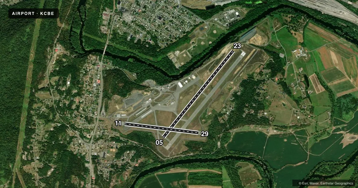
Runways & pattern
Full pagePattern entry · RWY 29
LEFT TRAFFIC| Runway | Heading (°M) | Length | Surface | Traffic |
|---|---|---|---|---|
| 05/23 | 29° / 209° | 4,495 ft | ASPH | 05 R |
| 11/29Favored | 87° / 267° | 3,000 ft | ASPH | Standard L |
Runway end performance
| End | TORA | TODA | ASDA | LDA | VGSI | Approach lights | Obstruction |
|---|---|---|---|---|---|---|---|
| 05 | — | — | — | — | — | — | 6', trees, 308' from thr, 5' R of cntrln, slope 18 |
| 11 | — | — | — | — | — | — | 336', hill, 4187' from thr, 0' R of cntrln, slope 11 |
Declared distances in feet. TORA = takeoff run available, TODA = takeoff distance, ASDA = accelerate-stop, LDA = landing distance.
Airport sketch
Runways drawn to scale from FAA survey coordinates, rendered over satellite imagery. Not for navigation.
Approaches & charts
ILS · 1
Services on the field
Fuel grades, oxygen, maintenance, ramp storage and lighting — as declared to the FAA by the airport operator.
Fuel & services
- Fuel
- 100LLA
- Oxygen (bottled)
- HIGH/LOW
- Oxygen (bulk)
- HIGH/LOW
- Airframe repair
- Not available
- Power plant repair
- Not available
- Other services
- AFRT,CARGO,GLD,INSTR,TOW
Ramp & ground
- Transient storage
- Tie-down
- Hangar
- Landing fee
- No fee published
- Customs
- Not available
- Lighting schedule
- SEE RMK
- Beacon schedule
- SS-SR
- Beacon
- White / Green (civil land)(WG)
- Wind indicator
- Lighted
- Segmented circle
- Yes
Fuel & FBOs
Cheapest 100LL and Jet A on the field and nearby. Always confirm with the FBO before taxi.
Airport notes
Surface conditions, obstructions, local procedures, lighting outages and other notes published with each FAA cycle.
General notes
- RWY 11 NGT OPNS & ANY LNDGS NOT RECOMMENDED DUE TO HIGH TERRAIN.
- GLIDER OPNS W OF ARPT USE RWY 11 FOR DEP; RWY 29 FOR ARR.
- DEER/BIRDS ON & INVOF ARPT.
- RWY 23 900 FT TWY ALIGNED WITH RWY WEST END.
- RWY 05 APCH HAS RAPIDLY RISING TERRAIN 696 FT L, 2000 FT FM THR.
- FOR CD CTC JOHNSTOWN APCH AT 814-532-5960, WHEN APCH CLSD CTC CLEVELAND ARTCC AT 440-774-0213.
- COLD TEMPERATURE AIRPORT. ALTITUDE CORRECTION REQUIRED AT OR BELOW -14C.
Lighting notes
- ROTG BCN LOCATED OFF ARPT.
- ACTVT REIL RWY 23; HIRL RWY 05/23; LIRL RWY 11/29; & TWY LGTS - CTAF.
Runway surface & condition
- 11/29NSTD LIRL FM RWY 11 THR TO RWY 11 DSPLCD THR, DUE TO IMPROPER LENS COLORS AND SPACING.
Approach & departure obstructions
- 05FADED
- 23FADED
- 29FADED
- 05RWY 05/23 MARKINGS & CL PARTIALLY OBSCURED BY LONGITUDINAL AND TRANSVERSE CRACK FILL. RWY 05/23 MARKINGS FADED.
Other notes
- ESTAB PRIOR 1959.
- BOTTLE OXY AVBL FM 0800-1500 MON-FRI BY PRIOR ARNGMT, CALL 304-738-0002.
- BULK OXY AVBL FM 0800-1500 MON-FRI BY PRIOR ARNGMT, CALL 304-738-0002.
- COUNTY LOCATED IN WV.
VFR map & nearby airports
VFR sectional. Tap any ICAO chip to open that airport.
Key facts · KCBE
Answer card- ICAO
- KCBE
- Name
- GREATER CUMBERLAND RGNL
- Location
- CUMBERLAND, MARYLAND
- Elevation
- 757.8 ft MSL
- Traffic pattern altitude
- 1,781.8 ft MSL (1,024 AGL)
- Control tower
- Non-towered (use CTAF)
- Total runways
- 2
- Longest runway
- 05/23 · 4,495 ft
- Published ILS approaches
- 1
- Published frequencies
- 4
- Magnetic variation
- 10°
- Current flight rules
- VFR
- Current wind
- 280° at 5 kt
- Favored runway now
- RWY 29
Greater Cumberland Regional Airport sits in Cumberland, Maryland. Field elevation is 757.8 ft MSL. The airport has two asphalt runways. The longest is runway 05/23 at 4,495 ft. This is a non-towered field. CTAF and UNICOM are both 122.8. Johnstown Approach handles clearance delivery. The published remarks also note Cleveland ARTCC for clearance when approach is closed. The airport has one ILS approach to runway 23. Pattern altitude is 1,024 ft AGL. That is 1,781.8 ft MSL.
The on-field FBO is Greater Cumberland Regional Airport. It carries AVGAS 100LL and Jet A Prist. Call (304) 738-0002 for current service details. Published remarks matter here. Runway 05/23 markings are faded. The centerline is partly obscured by crack fill. Runway 11 night operations and any landings are not recommended because of high terrain. Cold weather corrections are required at or below minus 14 degrees Celsius. Glider activity west of the airport uses runway 11 for departure and runway 29 for arrival. Lighting is pilot-controlled on CTAF. Runway 23 has REIL. Runway 05 and 23 have high intensity lighting. Runway 11 and 29 have low intensity lighting. The airport is established prior to 1959. A first-time pilot should plan for terrain. Watch the runway 11 note closely. Verify current procedures with the airport operator or the FBO before arrival.