METAR & TAF KOKV
Current METAR
Observed 10:35Z
KOKV 271035Z AUTO 00000KT 7SM CLR 17/16 A2987 RMK AO2
- Wind
- 000° @ 0 kt
- Visibility
- 7 SM
- Temp / Dew
- 17°C / 16°C
- Altimeter
- 29.87 inHg
- Clouds
- CLR
- Density alt
- 1,202 ft
- Ceiling
- Unlimited
- Rules
- VFR
Airport info & contacts
Manager on record, flight service, ARTCC, attendance schedule and pattern altitude — published by the FAA and refreshed every 28 days.
Location
- From city
- 3 NM SE
- VFR sectional
- WASHINGTON
- ARTCC
- ZDC · WASHINGTON
- NOTAM facility
- OKV (NOTAM-D)
Airport manager
- Name
- NICK SABO
- Phone
- 540-662-5786
- Address
- 491 AIRPORT RD, WINCHESTER VA 22602
Flight service · Hours
- FSS DCA
- LEESBURG1-800-WX-BRIEF
- Attendance
- 0600-2200 LCL
Frequencies
Tap any row to copy the frequency to your clipboard.
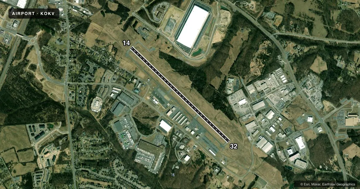
Runways & pattern
Full pagePattern entry · RWY 14
LEFT TRAFFICRunway end performance
| End | TORA | TODA | ASDA | LDA | VGSI | Approach lights | Obstruction |
|---|---|---|---|---|---|---|---|
| 14 | — | — | — | — | PAPI 4-box left(3°) | — | 27', tree, 664' from thr, 490' R of cntrln, slope 17 |
| 32 | — | — | — | — | PAPI 4-box left(3°) | MALSR | 60', tree, 1986' from thr, 736' R of cntrln, slope 29 |
Declared distances in feet. TORA = takeoff run available, TODA = takeoff distance, ASDA = accelerate-stop, LDA = landing distance.
Airport sketch
Runways drawn to scale from FAA survey coordinates, rendered over satellite imagery. Not for navigation.
Approaches & charts
ILS · 1
Services on the field
Fuel grades, oxygen, maintenance, ramp storage and lighting — as declared to the FAA by the airport operator.
Fuel & services
- Fuel
- 100LLA
- Oxygen (bottled)
- Not available
- Oxygen (bulk)
- Not available
- Airframe repair
- Major
- Power plant repair
- Major
- Other services
- AFRT,AVNCS,CHTR,INSTR,RNTL
Ramp & ground
- Transient storage
- Tie-down
- Hangar
- Landing fee
- No fee published
- Customs
- Not available
- Lighting schedule
- SEE RMK
- Beacon schedule
- SS-SR
- Beacon
- White / Green (civil land)(WG)
- Wind indicator
- Lighted
- Segmented circle
- Yes
Fuel & FBOs
Cheapest 100LL and Jet A on the field and nearby. Always confirm with the FBO before taxi.
Airport notes
Surface conditions, obstructions, local procedures, lighting outages and other notes published with each FAA cycle.
General notes
- ADCUS AVBL 24 HRS MIN ADVN NOTICE RQRD CALL 804-661-3660 MON-FRI; AFT HRS AND WKENDS CALL 703-661-3632.
- DEER ON & INVOF ARPT.
- MED-FLIGHT: IREG DEP PAT.
- FOR CD CTC POTOMAC APCH AT 866-709-4993.
Lighting notes
- ACTVT MALSR RWY 32; REIL RWY 14; HIRL RWY 14/32 - CTAF.
Other notes
- IN OPN PRIOR 1959.
- TPA 1980 FT AGL FOR TURBOPROP AND JET ACFT; ALL OTHER ACFT TPA 980 FT AGL.
- 1CALLOUT SVC AVBL. FEES MAY APPLY.
VFR map & nearby airports
VFR sectional. Tap any ICAO chip to open that airport.
Key facts · KOKV
Answer card- ICAO
- KOKV
- Name
- WINCHESTER RGNL
- Location
- WINCHESTER, VIRGINIA
- Elevation
- 726.2 ft MSL
- Traffic pattern altitude
- 1,726.2 ft MSL (1,000 AGL)
- Control tower
- Non-towered (use CTAF)
- Total runways
- 1
- Longest runway
- 14/32 · 5,498 ft
- Published ILS approaches
- 1
- Published frequencies
- 5
- Magnetic variation
- 10°
- Current flight rules
- VFR
- Current wind
- 000° at 0 kt
- Favored runway now
- –
Winchester Regional Airport sits in Winchester, Virginia. The field elevation is 726.2 ft MSL. It has one runway. Runway 14/32 is 5,498 ft long with asphalt pavement. The airport is non-towered. Potomac Approach handles approach and departure services. Clearance delivery is also through Potomac. The field has one ILS approach. It serves runway 32.
Traffic pattern altitude is 980 ft AGL for most aircraft. Turboprop and jet aircraft use 1,980 ft AGL. That is a useful number to brief before arrival. The published pattern is not the same for every aircraft type. Runway 32 has MALSR lighting. Runway 14 has runway end identifier lights. High intensity runway lights are available on both ends.
Winchester Regional Airport Authority is on the field. It carries 100LL and Jet A. Deer are reported on and near the airport. Medical flight traffic follows an irregular departure pattern, so keep a sharp scan when operating in the pattern or on departure. The airport has been in operation since before 1959. For ARFF coverage, the field asks for at least 24 hours notice. If you need that service, call ahead before arrival.