METAR & TAF KLUA
Current METAR
Observed 15:15Z
KLUA 271515Z AUTO 00000KT 10SM CLR 29/16 A2992 RMK AO2
- Wind
- 000° @ 0 kt
- Visibility
- 10 SM
- Temp / Dew
- 29°C / 16°C
- Altimeter
- 29.92 inHg
- Clouds
- CLR
- Density alt
- 2,799 ft
- Ceiling
- Unlimited
- Rules
- VFR
Airport info & contacts
Manager on record, flight service, ARTCC, attendance schedule and pattern altitude — published by the FAA and refreshed every 28 days.
Location
- From city
- 2 NM W
- VFR sectional
- WASHINGTON
- ARTCC
- ZDC · WASHINGTON
- NOTAM facility
- DCA (NOTAM-D)
Airport manager
- Name
- JAMES CULPEPPER
- Phone
- 540-743-6070
- Address
- 1086 AIRPORT ROAD, LURAY VA 22835
Flight service · Hours
- FSS DCA
- LEESBURG1-800-WX-BRIEF
- Attendance
- 0800-1800
Frequencies
Tap any row to copy the frequency to your clipboard.
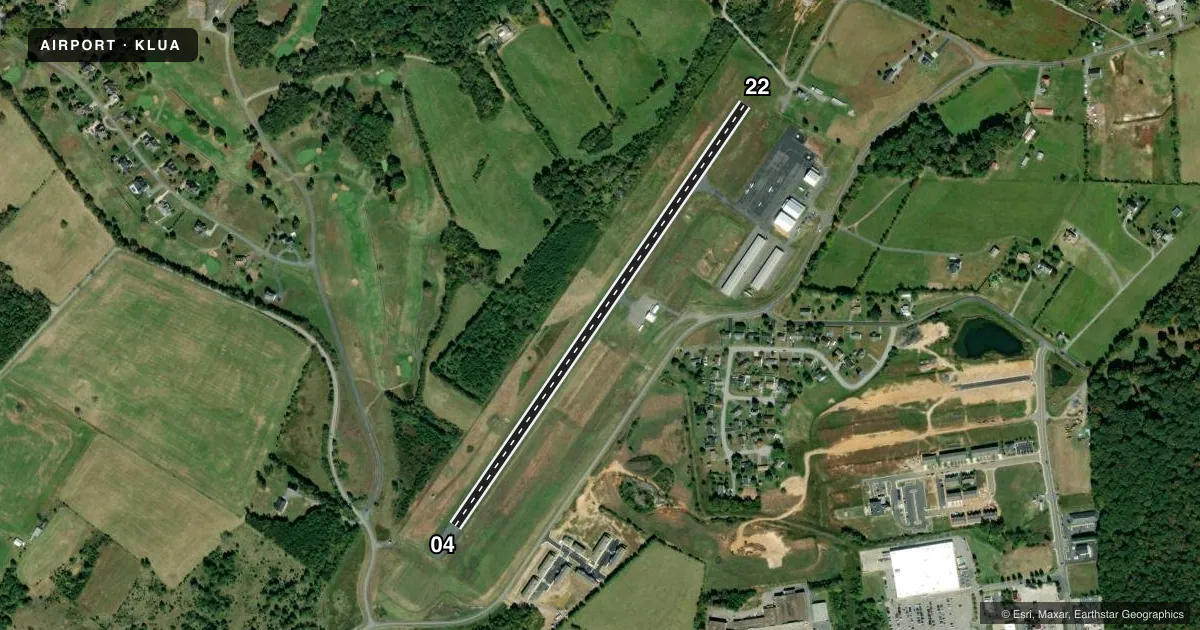
Runways & pattern
Full pagePattern entry · RWY 04
LEFT TRAFFICRunway end performance
| End | TORA | TODA | ASDA | LDA | VGSI | Approach lights | Obstruction |
|---|---|---|---|---|---|---|---|
| 04 | — | — | — | — | PAPI 2-box left(3°) | — | 28', tree, 940' from thr, 290' R of cntrln, slope 26 |
| 22 | — | — | — | — | PAPI 2-box left(3°) | — | 9', road, 200' from thr, 185' R of cntrln, slope 0 |
Declared distances in feet. TORA = takeoff run available, TODA = takeoff distance, ASDA = accelerate-stop, LDA = landing distance.
Airport sketch
Runways drawn to scale from FAA survey coordinates, rendered over satellite imagery. Not for navigation.
Approaches & charts
Services on the field
Fuel grades, oxygen, maintenance, ramp storage and lighting — as declared to the FAA by the airport operator.
Fuel & services
- Fuel
- 100LLA+
- Airframe repair
- Major
- Power plant repair
- Major
Ramp & ground
- Transient storage
- Tie-down
- Hangar
- Landing fee
- No fee published
- Lighting schedule
- SEE RMK
- Beacon schedule
- SS-SR
- Beacon
- White / Green (civil land)(WG)
- Wind indicator
- Lighted
- Segmented circle
- Yes
Fuel & FBOs
Cheapest 100LL and Jet A on the field and nearby. Always confirm with the FBO before taxi.
Airport notes
Surface conditions, obstructions, local procedures, lighting outages and other notes published with each FAA cycle.
General notes
- DEER AND BIRDS ON AND INVOF ARPT.
- FOR CD CTC WASHINGTON ARTCC AT 703-771-3587.
Lighting notes
- ACTVT REIL RWY 04/22; MIRL RWY 04/22 - CTAF.
Approach & departure obstructions
- 2210 FT ROAD LCTD 80 FT FM END OF RWY, 230 FT LEFT ON APCH.
- 04RWY 4 MRKGS CVRD WITH ALGAE.
- 22RWY 22 MRKGS CVRD WITH ALGAE.
Other notes
- RGT TFC FOR LNDG TO SW.
VFR map & nearby airports
VFR sectional. Tap any ICAO chip to open that airport.
Key facts · KLUA
Answer card- ICAO
- KLUA
- Name
- LURAY CAVERNS
- Location
- LURAY, VIRGINIA
- Elevation
- 902.4 ft MSL
- Traffic pattern altitude
- 1,902.4 ft MSL (1,000 AGL)
- Control tower
- Non-towered (use CTAF)
- Total runways
- 1
- Longest runway
- 04/22 · 3,126 ft
- Published ILS approaches
- 0
- Published frequencies
- 2
- Magnetic variation
- 9°
- Current flight rules
- VFR
- Current wind
- 000° at 0 kt
- Favored runway now
- –
Luray Caverns Airport is in Luray, Virginia. Field elevation is 902.4 ft MSL. The airport has one runway. Runway 04/22 is 3,126 ft long and asphalt. There is no control tower. CTAF and UNICOM are both 122.8. No ILS approaches are published.
Pattern altitude is not published. Use 1,000 ft AGL for light piston traffic unless the current Chart Supplement says otherwise. The on-field FBO is Luray Caverns Airport. It carries 100LL and Jet A. Call (540) 743-6070 before arrival if you need current ramp or fuel details.
A few published remarks matter here. Deer and birds are reported on and near the field. Runway 04 and runway 22 markings are covered with algae. Right traffic is used for landings to the southwest. Runway 22 also has a road close beyond the departure end on the left side of the approach path. Runway end identifier lights are on runway 04/22. Medium intensity runway lights are also on runway 04/22 and are controlled by CTAF. This is a good field to brief carefully before arrival. Check the current Chart Supplement for any other local procedures or restrictions before you go.