METAR & TAF KOMH
Current METAR
Observed 15:15Z
KOMH 271515Z AUTO 00000KT 10SM 26/18 A2988 RMK AO2
- Wind
- 000° @ 0 kt
- Visibility
- 10 SM
- Temp / Dew
- 26°C / 18°C
- Altimeter
- 29.88 inHg
- Clouds
- Clear
- Density alt
- 1,945 ft
- Ceiling
- Unlimited
- Rules
- VFR
Airport info & contacts
Manager on record, flight service, ARTCC, attendance schedule and pattern altitude — published by the FAA and refreshed every 28 days.
Location
- From city
- 3 NM E
- VFR sectional
- WASHINGTON
- ARTCC
- ZDC · WASHINGTON
- NOTAM facility
- OMH (NOTAM-D)
Airport manager
- Name
- PAUL J. WEBER
- Phone
- 540-672-2158
- Address
- 11275 AVIATION WAY, ORANGE VA 22960
Flight service · Hours
- FSS DCA
- LEESBURG1-800-WX-BRIEF
- Attendance
- 0800-1700
Frequencies
Tap any row to copy the frequency to your clipboard.
Runways & pattern
Full pagePattern entry · RWY 08
LEFT TRAFFICRunway end performance
| End | TORA | TODA | ASDA | LDA | VGSI | Approach lights | Obstruction |
|---|---|---|---|---|---|---|---|
| 08 | — | — | — | — | PAPI 2-box left(4°) | — | 103', tree, 2389' from thr, 374' R of cntrln, slope 21 |
| 26 | — | — | — | — | PAPI 2-box left(4°) | — | 60', pole, 1185' from thr, 381' R of cntrln, slope 16 |
Declared distances in feet. TORA = takeoff run available, TODA = takeoff distance, ASDA = accelerate-stop, LDA = landing distance.
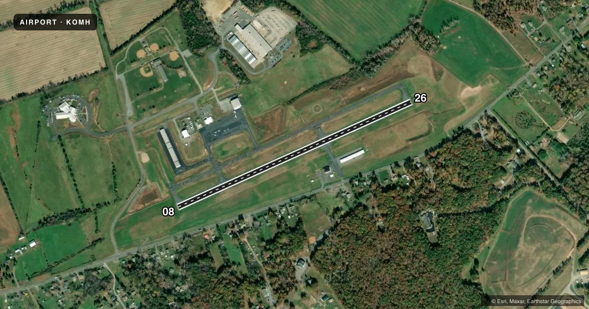
Airport sketch
Runways drawn to scale from FAA survey coordinates, rendered over satellite imagery. Not for navigation.
Approaches & charts
Services on the field
Fuel grades, oxygen, maintenance, ramp storage and lighting — as declared to the FAA by the airport operator.
Fuel & services
- Fuel
- 100LLA+
- Oxygen (bottled)
- Not available
- Oxygen (bulk)
- Not available
- Airframe repair
- Not available
- Power plant repair
- Not available
- Other services
- INSTR,PAJA
Ramp & ground
- Transient storage
- Tie-down
- Landing fee
- No fee published
- Customs
- Not available
- Lighting schedule
- SEE RMK
- Beacon schedule
- SS-SR
- Beacon
- White / Green (civil land)(WG)
- Wind indicator
- Lighted
- Segmented circle
- Yes
Fuel & FBOs
Cheapest 100LL and Jet A on the field and nearby. Always confirm with the FBO before taxi.
Airport notes
Surface conditions, obstructions, local procedures, lighting outages and other notes published with each FAA cycle.
General notes
- FOR CD CTC POTOMAC APCH AT 866-640-4124.
- PARACHUTE OPS.
Lighting notes
- ACTVT REIL RWY 08 & 26; PAPI RWY 08 & 26; MIRL RWY 08/26 - CTAF.
Fuel notes
- 100LL100LL SELF SERVICE AFTER HOURS.
- A+JET-A+ SELF SERVICE AFTER HOURS.
Other notes
- PRIOR TO 1959.
- 1UNATDD FEDERAL HOL & EASTER.
- MANAGERMOBILE 540-406-1821
VFR map & nearby airports
VFR sectional. Tap any ICAO chip to open that airport.
Key facts · KOMH
Answer card- ICAO
- KOMH
- Name
- ORANGE COUNTY
- Location
- ORANGE, VIRGINIA
- Elevation
- 464.4 ft MSL
- Traffic pattern altitude
- 1,464.4 ft MSL (1,000 AGL)
- Control tower
- Non-towered (use CTAF)
- Total runways
- 1
- Longest runway
- 08/26 · 3,200 ft
- Published ILS approaches
- 0
- Published frequencies
- 5
- Magnetic variation
- 9°
- Current flight rules
- VFR
- Current wind
- 000° at 0 kt
- Favored runway now
- –
Orange County Airport sits in Orange, Virginia. The field elevation is 464.4 ft MSL. It has one runway, 08/26, which is 3,200 ft long. The airport is not towered. CTAF and UNICOM are both 122.8. Potomac Approach handles clearance delivery and area approach service.
No ILS approaches are published here. Runway 08/26 has medium intensity runway lights. They are controlled on CTAF. Runway end identifier lights are installed on both ends. Precision approach path indicators are also installed on runways 08 and 26. Pattern altitude is not published, so a light piston pilot should plan on the standard 1,000 ft AGL unless the current Chart Supplement says otherwise.
Orange County Airport, the on-field FBO, carries 100LL and Jet A. Jet-A+ fuel is self-serve after hours. 100LL is also self-serve after hours. The airport is unattended on federal holidays and Easter. Parachute operations occur here, so watch the pattern and listen carefully before entering. If you need current airport details or local coordination, call the airport operator or the FBO directly before arrival.