METAR & TAF KLKU
Current METAR
Observed 15:35Z
KLKU 271535Z AUTO 34007KT 10SM CLR 27/20 A2989 RMK AO2 T02700200
- Wind
- 340° @ 7 kt
- Visibility
- 10 SM
- Temp / Dew
- 27°C / 20°C
- Altimeter
- 29.89 inHg
- Clouds
- CLR
- Density alt
- 2,089 ft
- Ceiling
- Unlimited
- Rules
- VFR
Airport info & contacts
Manager on record, flight service, ARTCC, attendance schedule and pattern altitude — published by the FAA and refreshed every 28 days.
Location
- From city
- 2 NM SE
- VFR sectional
- WASHINGTON
- ARTCC
- ZDC · WASHINGTON
- NOTAM facility
- LKU (NOTAM-D)
Airport manager
- Name
- BRITTANY SHUPE
- Phone
- 540-967-0050
- Address
- 335 INDUSTRIAL DR, P.O. BOX 27, LOUISA VA 23093
Flight service · Hours
- FSS DCA
- LEESBURG1-800-WX-BRIEF
- Attendance
- MON-SAT · 0830-1700
- SUN · 1000-1700
Frequencies
Tap any row to copy the frequency to your clipboard.
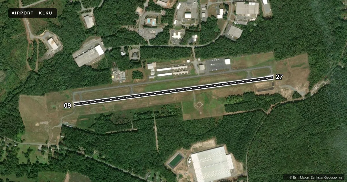
Runways & pattern
Full pagePattern entry · RWY 27
LEFT TRAFFICRunway end performance
| End | TORA | TODA | ASDA | LDA | VGSI | Approach lights | Obstruction |
|---|---|---|---|---|---|---|---|
| 09 | — | — | — | — | PAPI 2-box left(3°) | — | 50', trees, 1147' from thr, 344' R of cntrln, slope 18 |
| 27 | — | — | — | — | PAPI 2-box left(3°) | — | — |
Declared distances in feet. TORA = takeoff run available, TODA = takeoff distance, ASDA = accelerate-stop, LDA = landing distance.
Airport sketch
Runways drawn to scale from FAA survey coordinates, rendered over satellite imagery. Not for navigation.
Approaches & charts
ILS · 1
Services on the field
Fuel grades, oxygen, maintenance, ramp storage and lighting — as declared to the FAA by the airport operator.
Fuel & services
- Fuel
- 100LLA
- Airframe repair
- Major
- Power plant repair
- Major
- Other services
- INSTR
Ramp & ground
- Transient storage
- Tie-down
- Hangar
- Lighting schedule
- SEE RMK
- Beacon schedule
- SS-SR
- Beacon
- White / Green (civil land)(WG)
- Wind indicator
- Lighted
- Segmented circle
- Yes
Fuel & FBOs
Cheapest 100LL and Jet A on the field and nearby. Always confirm with the FBO before taxi.
Airport notes
Surface conditions, obstructions, local procedures, lighting outages and other notes published with each FAA cycle.
General notes
- BCN LOCATED ON WATER TWR; NORTH SIDE APCH RY 27.
- DEER & BIRDS ON & INVOF ARPT.
- 3 FT PVC GAS LINE MARKER LCTD APRX 26 FT FM RY 09 THLD, 54 FT LEFT OF CNTRLN.
- FOR CD CTC POTOMAC APCH AT 540-349-9697
Lighting notes
- ACTVT REIL RWY 09/27; PAPI RWY 09 & 27; MIRL RWY 09/27 - CTAF.
Other notes
- MANAGERBSHUPE@LOUISACOUNTY.GOV
VFR map & nearby airports
VFR sectional. Tap any ICAO chip to open that airport.
Key facts · KLKU
Answer card- ICAO
- KLKU
- Name
- LOUISA COUNTY/FREEMAN FLD
- Location
- LOUISA, VIRGINIA
- Elevation
- 493.7 ft MSL
- Traffic pattern altitude
- 1,493.7 ft MSL (1,000 AGL)
- Control tower
- Non-towered (use CTAF)
- Total runways
- 1
- Longest runway
- 09/27 · 4,300 ft
- Published ILS approaches
- 1
- Published frequencies
- 5
- Magnetic variation
- 10°
- Current flight rules
- VFR
- Current wind
- 340° at 7 kt
- Favored runway now
- RWY 27
Louisa County/Freeman Fld is in Louisa, Virginia. Field elevation is 493.7 ft MSL. The airport has one runway, 09/27. It is 4,300 ft long. There is no control tower. Pattern altitude is not published, so use the standard 1,000 ft AGL for light piston traffic unless the current Chart Supplement says otherwise.
Runway 27 has an ILS approach. The airport also has PAPI and runway end identifier lights on 09/27. Medium intensity runway lights are controlled by CTAF. That makes the field workable after dark. You still need to brief the lighting setup before arrival. The runway threshold area on 09 has a published PVC gas line marker close to the pavement. Deer and birds are also reported on and near the airport, so keep a sharp scan on short final and in the pattern.
Louisa County Airport is the on-field FBO. It carries 100LL and Jet A with Prist. Call the FBO directly at (540) 967-0050 for current service details. For clearance delivery, Potomac Approach can be reached at 540-349-9697. The beacon is on the water tower on the north side approach to runway 27. This is a non-towered field with Potomac frequencies in use, so get the current procedures and airspace picture before you launch.