METAR & TAF KOFP
Current METAR
Observed 12:54Z
KOFP 271254Z AUTO 31008KT 8SM CLR 23/21 A2989 RMK AO2 SLP119 T02280206
- Wind
- 310° @ 8 kt
- Visibility
- 8 SM
- Temp / Dew
- 23°C / 21°C
- Altimeter
- 29.89 inHg
- Clouds
- CLR
- Density alt
- 1,254 ft
- Ceiling
- Unlimited
- Rules
- VFR
Airport info & contacts
Manager on record, flight service, ARTCC, attendance schedule and pattern altitude — published by the FAA and refreshed every 28 days.
Location
- From city
- 8 NM N
- VFR sectional
- WASHINGTON
- Pattern altitude
- 800 ft AGL · 1,007 ft MSL
- ARTCC
- ZDC · WASHINGTON
- NOTAM facility
- OFP (NOTAM-D)
Airport manager
- Name
- CHARLES J SOBRITO
- Phone
- 804-365-6208
- Address
- DEPARTMENT OF PUBLIC WORKS, PO BOX 470, HANOVER VA 23069
Flight service · Hours
- FSS DCA
- LEESBURG1-800-WX-BRIEF
- Attendance
- JAN - DEC · 0700-1900
Frequencies
Tap any row to copy the frequency to your clipboard.
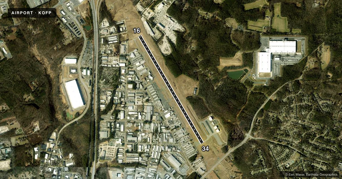
Runways & pattern
Full pagePattern entry · RWY 34
LEFT TRAFFICRunway end performance
| End | TORA | TODA | ASDA | LDA | VGSI | Approach lights | Obstruction |
|---|---|---|---|---|---|---|---|
| 16 | — | — | — | — | PAPI 4-box left(3°) | — | 82', tree, 1644' from thr, 450' R of cntrln, slope 17 |
| 34 | — | — | — | — | PAPI 4-box left(3°) | — | 98', trees, 3315' from thr, 319' R of cntrln, slope 31 |
Declared distances in feet. TORA = takeoff run available, TODA = takeoff distance, ASDA = accelerate-stop, LDA = landing distance.
Airport sketch
Runways drawn to scale from FAA survey coordinates, rendered over satellite imagery. Not for navigation.
Approaches & charts
ILS · 1
Services on the field
Fuel grades, oxygen, maintenance, ramp storage and lighting — as declared to the FAA by the airport operator.
Fuel & services
- Fuel
- 100LLA
- Oxygen (bottled)
- HIGH/LOW
- Oxygen (bulk)
- HIGH/LOW
- Airframe repair
- Major
- Power plant repair
- Major
- Other services
- AFRT,AGRI,AMB,CARGO,CHTR,GLD,INSTR,RNTL,SALES,SURV,TOW
Ramp & ground
- Transient storage
- Tie-down
- Hangar
- Landing fee
- No fee published
- Customs
- Not available
- Lighting schedule
- SEE RMK
- Beacon schedule
- SS-SR
- Beacon
- White / Green (civil land)(WG)
- Wind indicator
- Lighted
- Segmented circle
- Yes
Fuel & FBOs
Cheapest 100LL and Jet A on the field and nearby. Always confirm with the FBO before taxi.
Airport notes
Surface conditions, obstructions, local procedures, lighting outages and other notes published with each FAA cycle.
General notes
- NOISE SENSITIVE AREA S OF ARPT.
- FOR ARPT SVCS CALL 804-798-6500.
- DEER & BIRDS ON & INVOF ARPT.
- FOR CD CTC POTOMAC APCH AT 866-640-4124.
- RWY 34 PREF RWY WITH WIND LESS THAN 5 KT.
- ACFT ON APCH TO KRIC RWY 16 XNG OVR ARPT.
Lighting notes
- ACTVT REIL RWY 16 & 34; PAPI RWY 16 & 34; HIRL RWY 16/34 - CTAF.
Runway surface & condition
- 16/34PCR VALUE: 210/F/D/X/T
VFR map & nearby airports
VFR sectional. Tap any ICAO chip to open that airport.
Key facts · KOFP
Answer card- ICAO
- KOFP
- Name
- HANOVER COUNTY MUNI
- Location
- RICHMOND/ASHLAND, VIRGINIA
- Elevation
- 206.8 ft MSL
- Traffic pattern altitude
- 1,006.8 ft MSL (800 AGL)
- Control tower
- Non-towered (use CTAF)
- Total runways
- 1
- Longest runway
- 16/34 · 5,402 ft
- Published ILS approaches
- 1
- Published frequencies
- 8
- Magnetic variation
- 9°
- Current flight rules
- VFR
- Current wind
- 310° at 8 kt
- Favored runway now
- RWY 34
Hanover County Muni sits in Richmond/Ashland, Virginia. Field elevation is 206.8 ft MSL. The airport has one runway, 16/34, which is 5,402 ft long and paved with asphalt. There is no control tower. Pattern altitude is 800 ft AGL, which is 1,006.8 ft MSL.
The field has one ILS approach. It serves runway 16. Runway 34 is the preferred runway when the wind is less than 5 knots. Runway end identifier lights are active on both ends. Precision approach path indicators are also on 16 and 34. High intensity runway lights are on 16/34. They are controlled on the CTAF. For clearance delivery, Potomac Approach is listed in the remarks. The airport also has a noise sensitive area south of the field. Plan your departure and arrival with that in mind.
HOVA Flight Services is on the field. It carries AVGAS 100LL and Jet A. Deer and birds are reported on and near the airport. Keep a sharp scan on taxi, takeoff and landing. For airport services, call the number in the Chart Supplement or contact the FBO directly before you go.