METAR & TAF KXSA
Current METAR
Observed 04:55Z
KXSA 270455Z AUTO 21/21 A2989 RMK AO2 LTG DSNT N THRU S P0019 T02100210 PWINO
- Wind
- Calm
- Visibility
- —
- Temp / Dew
- 21°C / 21°C
- Altimeter
- 29.89 inHg
- Clouds
- Clear
- Density alt
- 925 ft
- Ceiling
- Unlimited
- Rules
- VFR
Airport info & contacts
Manager on record, flight service, ARTCC, attendance schedule and pattern altitude — published by the FAA and refreshed every 28 days.
Location
- From city
- 5 NM S
- VFR sectional
- WASHINGTON
- ARTCC
- ZDC · WASHINGTON
- NOTAM facility
- XSA (NOTAM-D)
Airport manager
- Name
- JIM EVANS
- Phone
- 804-443-5885
- Address
- 1450 AVIATION ROAD, TAPPAHANNOCK VA 22560
Flight service · Hours
- FSS DCA
- LEESBURG1-800-WX-BRIEF
- Attendance
- NOV - FEB · 0800-1800
- MAR - OCT · 0900-1900
Frequencies
Tap any row to copy the frequency to your clipboard.
Runways & pattern
Full pagePattern entry · RWY 10
LEFT TRAFFICRunway end performance
| End | TORA | TODA | ASDA | LDA | VGSI | Approach lights | Obstruction |
|---|---|---|---|---|---|---|---|
| 10 | — | — | — | — | PAPI 2-box left(3°) | — | 106', trees, 2374' from thr, 308' R of cntrln, slope 20 |
| 28 | — | — | — | — | PAPI 2-box left(3°) | — | 15', tree, 818' from thr, 128' R of cntrln, slope 41 |
Declared distances in feet. TORA = takeoff run available, TODA = takeoff distance, ASDA = accelerate-stop, LDA = landing distance.
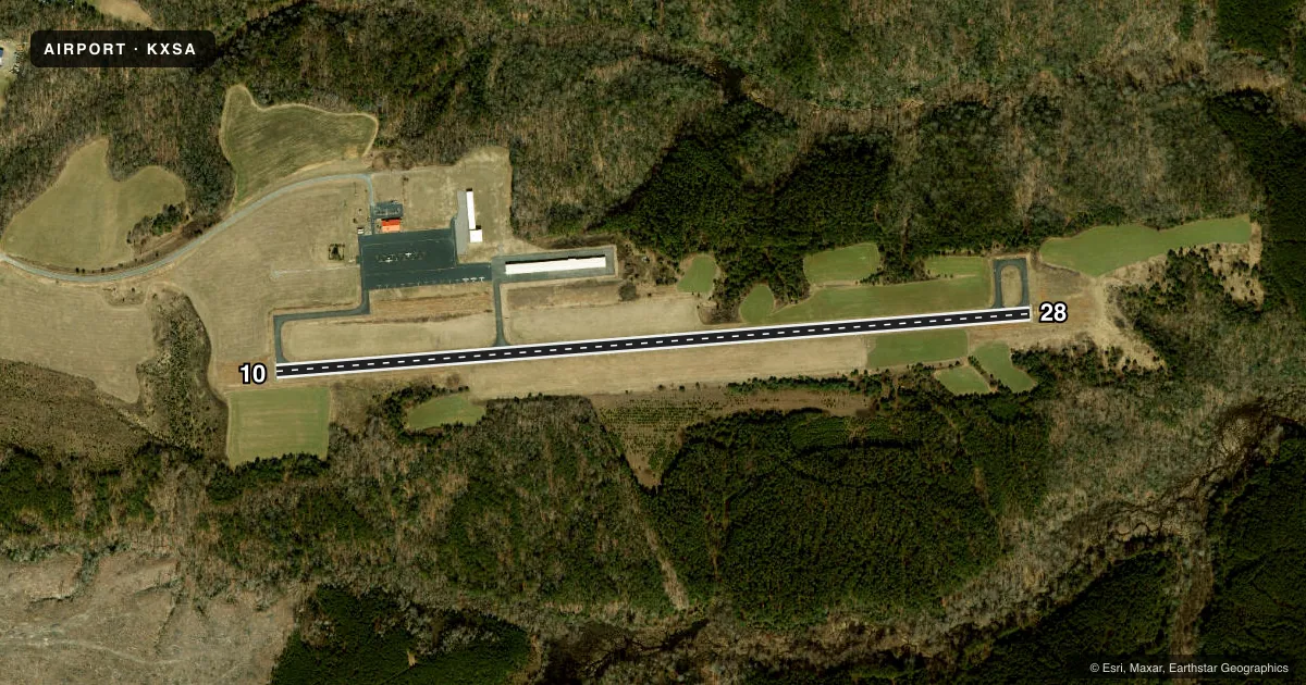
Airport sketch
Runways drawn to scale from FAA survey coordinates, rendered over satellite imagery. Not for navigation.
Approaches & charts
Services on the field
Fuel grades, oxygen, maintenance, ramp storage and lighting — as declared to the FAA by the airport operator.
Fuel & services
- Fuel
- 100LLA
- Airframe repair
- Major
- Power plant repair
- Major
Ramp & ground
- Transient storage
- Tie-down
- Hangar
- Lighting schedule
- SEE RMK
- Beacon schedule
- SEE RMK
- Beacon
- White / Green (civil land)(WG)
- Wind indicator
- Lighted
- Segmented circle
- No
Fuel & FBOs
Cheapest 100LL and Jet A on the field and nearby. Always confirm with the FBO before taxi.
Airport notes
Surface conditions, obstructions, local procedures, lighting outages and other notes published with each FAA cycle.
General notes
- DEER & OTHER WILDLIFE ON & INVOF ARPT.
- FOR CD CTC POTOMAC APCH AT 866-640-4124.
Lighting notes
- ACTVT ROTG BCN - CTAF.
- ACTVT PAPI RWY 10 & 28; MIRL RWY 10/28 - CTAF.
Approach & departure obstructions
- 286 FT TREE 196 FT FM THLD, 231 L OF CNTRLN ON APCH
VFR map & nearby airports
VFR sectional. Tap any ICAO chip to open that airport.
Key facts · KXSA
Answer card- ICAO
- KXSA
- Name
- TAPPAHANNOCK/ESSEX COUNTY
- Location
- TAPPAHANNOCK, VIRGINIA
- Elevation
- 135.2 ft MSL
- Traffic pattern altitude
- 1,135.2 ft MSL (1,000 AGL)
- Control tower
- Non-towered (use CTAF)
- Total runways
- 1
- Longest runway
- 10/28 · 4,300 ft
- Published ILS approaches
- 0
- Published frequencies
- 4
- Magnetic variation
- 11°
- Current flight rules
- VFR
- Current wind
- Calm / unavailable
- Favored runway now
- –
Tappahannock/Essex County Airport sits in Tappahannock, Virginia. Field elevation is 135.2 ft MSL. The airport has one runway. Runway 10/28 is 4,300 ft long and asphalt. There is no control tower. Potomac Approach handles the area. Clearance delivery is by phone with Potomac Approach when needed.
No ILS approaches are published here. Pattern altitude is not published, so use the standard 1,000 ft AGL unless the current Chart Supplement says otherwise. The field is served by CTAF and UNICOM on 122.8. The rotating beacon comes on with the CTAF. The PAPI for runways 10 and 28 also comes on with the CTAF. Medium intensity runway lights for 10/28 use the same activation.
Tappahannock-Essex County Airport is the on-field FBO. It carries 100LL and Jet A. Deer and other wildlife are reported on and near the airport. Plan for a careful taxi and takeoff scan. There is also a tree obstruction near the approach end of runway 28. If you are landing 28, keep that in mind on short final. For current operational details, check the current FAA Chart Supplement or call the airport operator before departure.