METAR & TAF KJGG
Current METAR
Observed 13:35Z
KJGG 271335Z AUTO 34004KT 8SM CLR 26/21 A2985 RMK AO2 T02590212
- Wind
- 340° @ 4 kt
- Visibility
- 8 SM
- Temp / Dew
- 26°C / 21°C
- Altimeter
- 29.85 inHg
- Clouds
- CLR
- Density alt
- 1,468 ft
- Ceiling
- Unlimited
- Rules
- VFR
Airport info & contacts
Manager on record, flight service, ARTCC, attendance schedule and pattern altitude — published by the FAA and refreshed every 28 days.
Location
- From city
- 3 NM SW
- VFR sectional
- WASHINGTON
- Pattern altitude
- 800 ft AGL · 849 ft MSL
- ARTCC
- ZDC · WASHINGTON
- NOTAM facility
- JGG (NOTAM-D)
Airport manager
- Name
- HERON WEIDNER
- Phone
- 757-229-9256
- Address
- 100 MARCLAY RD, WILLIAMSBURG VA 23185
Flight service · Hours
- FSS DCA
- LEESBURG1-800-WX-BRIEF
- Attendance
- NOV-FEB · 0800-1800
- MAR-OCT · 0800-1900
Frequencies
Tap any row to copy the frequency to your clipboard.
Runways & pattern
Full pagePattern entry · RWY 31
LEFT TRAFFICRunway end performance
| End | TORA | TODA | ASDA | LDA | VGSI | Approach lights | Obstruction |
|---|---|---|---|---|---|---|---|
| 13 | — | — | — | — | — | — | 56', tree, 839' from thr, 127' R of cntrln, slope 11 |
| 31 | — | — | — | — | — | — | 116', tree, 1790' from thr, 220' R of cntrln, slope 13 |
Declared distances in feet. TORA = takeoff run available, TODA = takeoff distance, ASDA = accelerate-stop, LDA = landing distance.
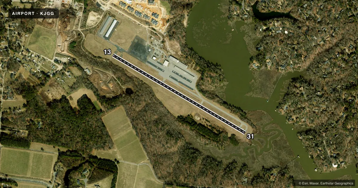
Airport sketch
Runways drawn to scale from FAA survey coordinates, rendered over satellite imagery. Not for navigation.
Approaches & charts
Services on the field
Fuel grades, oxygen, maintenance, ramp storage and lighting — as declared to the FAA by the airport operator.
Fuel & services
- Fuel
- 100LLA+
- Oxygen (bottled)
- Not available
- Oxygen (bulk)
- Not available
- Airframe repair
- Major
- Power plant repair
- Major
- Other services
- INSTR,RNTL
Ramp & ground
- Transient storage
- Tie-down
- Hangar
- Landing fee
- Yes
- Customs
- Not available
- Lighting schedule
- SEE RMK
- Beacon schedule
- SS-SR
- Beacon
- White / Green (civil land)(WG)
- Wind indicator
- Lighted
- Segmented circle
- No
Fuel & FBOs
Cheapest 100LL and Jet A on the field and nearby. Always confirm with the FBO before taxi.
Airport notes
Surface conditions, obstructions, local procedures, lighting outages and other notes published with each FAA cycle.
General notes
- DEER & BIRDS ON & INVOF ARPT.
- NOISE ABATEMENT PROCEDURES IN EFFECT; CTC AMGR 757-229-9256. RY 31 DEP TURN LEFT HEADING 270 DEG TO AVOID SCHOOL 3500 FT OFF RY END.
- GCO AVBL ON FREQ 135.075 THRU NORFOLK CD, 4 CLICKS NORFOLK, 5 LEESBURG RADIO (CLICK SLOWLY). IF UN, FOR CD CTC NORFOLK APCH AT 757-464-0757.
- HELIPAD CLSD CT 122.8 FOR LDG INSTRUCTIONS.
- PAEW ADJECENT TO RY 13/31.
Lighting notes
- ACTVT REIL RWY 13 & 31; MIRL RY 13/31; PERIMETER LGTS RY H1 - CTAF.
Approach & departure obstructions
- 3113 FT TREE 150 FT FM THR 115 L OF CNTRLN; BRUSH APRX 120 FT FM THR, ARND PEN EDGE, 10 FT ABV RWY END.
- 31200 FT DTHR. CLR SLP 15:1 TO DTHR.
Other notes
- THIS AIRPORT HAS BEEN SURVEYED BY THE NATIONAL GEODETIC SURVEY.
- 1ARPT UNATTND CHRISTMAS DAY - ATTND BY REQUEST.
- 13/31NMRS CRACKS IN RWY PAVEMENT. PCI VALUE OF 45.
VFR map & nearby airports
VFR sectional. Tap any ICAO chip to open that airport.
Key facts · KJGG
Answer card- ICAO
- KJGG
- Name
- WALTRIP WILLIAMSBURG EXEC AIRPORT
- Location
- WILLIAMSBURG, VIRGINIA
- Elevation
- 49 ft MSL
- Traffic pattern altitude
- 849 ft MSL (800 AGL)
- Control tower
- Non-towered (use CTAF)
- Total runways
- 1
- Longest runway
- 13/31 · 3,204 ft
- Published ILS approaches
- 0
- Published frequencies
- 4
- Magnetic variation
- 11°
- Current flight rules
- VFR
- Current wind
- 340° at 4 kt
- Favored runway now
- RWY 31
WALTRIP WILLIAMSBURG EXEC AIRPORT sits in Williamsburg, Virginia. Field elevation is 49 ft MSL. The airport has one runway, 13/31, at 3,204 ft. There is no control tower. Pattern altitude is 800 ft AGL, which is 849 ft MSL. No ILS approaches are published here, so plan with the current charted procedures and Norfolk approach data in mind.
Williamsburg-Jamestown Airport is the on-field FBO. It carries AVGAS 100LL and Jet A Prist. Call ahead at (757) 229-9256 for current service. The airport remarks also note noise abatement procedures. Runway 31 departures call for a left turn to heading 270 degrees to avoid the school off the departure end. Runway 31 also has a 200 ft displaced threshold. There are trees and brush near that end, so pay close attention on short final.
Expect a few operational details that matter on a first visit. Deer and birds are reported on and near the field. The runway pavement has numerous cracks and a pavement condition index of 45. Runway lights and runway end identifier lights are available on 13/31. The helipad is closed. For current clearance, communications, or any question about procedures, use the current FAA Chart Supplement or call the airport manager directly.