METAR & TAF KPVG
Current METAR
Observed 05:56Z
KPVG 270556Z AUTO 19003KT 10SM FEW090 19/19 A2988 RMK AO2 SLP121 T01890189 10250 20189 58006 $
- Wind
- 190° @ 3 kt
- Visibility
- 10 SM
- Temp / Dew
- 19°C / 19°C
- Altimeter
- 29.88 inHg
- Clouds
- FEW
- Density alt
- 564 ft
- Ceiling
- Unlimited
- Rules
- VFR
Airport info & contacts
Manager on record, flight service, ARTCC, attendance schedule and pattern altitude — published by the FAA and refreshed every 28 days.
Location
- From city
- 7 NM SW
- VFR sectional
- WASHINGTON
- ARTCC
- ZDC · WASHINGTON
- NOTAM facility
- DCA (NOTAM-D)
Airport manager
- Name
- STEVE FOX
- Phone
- 757-465-0260
- Address
- 5172 W. MILITARY HWY, CHESAPEAKE VA 23321
Flight service · Hours
- FSS DCA
- LEESBURG1-800-WX-BRIEF
- Attendance
- 0700 - 1900
Frequencies
Tap any row to copy the frequency to your clipboard.
Runways & pattern
Full pagePattern entry · RWY 20
RIGHT TRAFFIC| Runway | Heading (°M) | Length | Surface | Traffic |
|---|---|---|---|---|
| 10/28 | 82° / 262° | 5,350 ft | ASPH | 10 R |
| 02/20Favored | 359° / 179° | 3,525 ft | ASPH | 20 R |
Runway end performance
| End | TORA | TODA | ASDA | LDA | VGSI | Approach lights | Obstruction |
|---|---|---|---|---|---|---|---|
| 10 | — | — | — | — | PAPI 4-box left(3°) | — | 44', tree, 1429' from thr, 201' R of cntrln, slope 27 |
| 28 | — | — | — | — | PAPI 4-box left(3°) | — | 50', tree, 1109' from thr, 278' R of cntrln, slope 18 |
| 02 | — | — | — | — | — | — | 10', road, 244' from thr, 125' R of cntrln, slope 4 |
| 20 | — | — | — | — | — | — | 63', trees, 629' from thr, 144' R of cntrln, slope 6 |
Declared distances in feet. TORA = takeoff run available, TODA = takeoff distance, ASDA = accelerate-stop, LDA = landing distance.
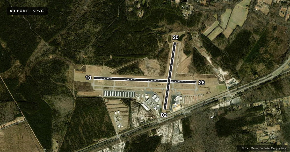
Airport sketch
Runways drawn to scale from FAA survey coordinates, rendered over satellite imagery. Not for navigation.
Approaches & charts
ILS · 1
Services on the field
Fuel grades, oxygen, maintenance, ramp storage and lighting — as declared to the FAA by the airport operator.
Fuel & services
- Fuel
- 100LLA+
- Oxygen (bottled)
- Not available
- Oxygen (bulk)
- Not available
- Airframe repair
- Major
- Power plant repair
- Major
- Other services
- AVNCS,INSTR,RNTL,SALES,SURV
Ramp & ground
- Transient storage
- Tie-down
- Hangar
- Landing fee
- No fee published
- Customs
- Not available
- Lighting schedule
- SEE RMK
- Beacon schedule
- SS-SR
- Beacon
- White / Green (civil land)(WG)
- Wind indicator
- Lighted
- Segmented circle
- No
Fuel & FBOs
Cheapest 100LL and Jet A on the field and nearby. Always confirm with the FBO before taxi.
Airport notes
Surface conditions, obstructions, local procedures, lighting outages and other notes published with each FAA cycle.
General notes
- DEER ON & INVOF ARPT.
- EXTENSIVE HELICOPTER TRAINING.
- RWY 10/28 PREFERRED USE RWY. BE ALERT FOR MULTIPLE 1000 FT AGL TWRS 1.5 NM NW OF FLD.
- FOR CD CTC NORFOLK APCH AT 757-464-0757.
Lighting notes
- ACTVT REIL RWY 10 & 28; PAPI RWY 10 & 28; MIRL RWY 02/20; HIRL RWY 10/28 - CTAF.
Approach & departure obstructions
- 28BRUSH LCTD APRXLY 240 FT FM CNTRLN.
- 02CLR SLP 16:1 TREE LCTD 1546 FT FM THR 208 FT RIGHT ON APCH.
- 20CLR SLP 17:1 TREE LCTD 1537 FT FM THR 212 FT R ON APCH.
- 10FIXED WING ACFT.
- 20FIXED WING ACFT.
- 02APCH RATIO 94:1 TO DSPLCD THR (ROAD); APCH RATIO 22:1 TO DSPLCD THR FM 70 FT TREE 883 FT FM RWY END, 189 FT LEFT.
- 20APCH RATIO 22:1 TO DSPLCD THR CTLG OBST; APCH RATIO 21:1 TO DSPLCD THR FM 104 FT TREE 1505 FT FM RWY END, 108 FT RIGHT.
Other notes
- IN OPERN PRIOR TO 1959.
- TPA 677 FT AGL FOR HELICOPTERS.
- MANAGERSTEVEN I. FOX AUTH PSNAL TO MAKE CHGS 757-465-0260.
- 02/20RWY HAS NMRS CRACKS. TWYS SUPPORTING RWY HAVE NMRS CRACKS AND FOD POTENTIAL.
VFR map & nearby airports
VFR sectional. Tap any ICAO chip to open that airport.
Key facts · KPVG
Answer card- ICAO
- KPVG
- Name
- HAMPTON ROADS EXEC
- Location
- NORFOLK, VIRGINIA
- Elevation
- 28 ft MSL
- Traffic pattern altitude
- 1,028 ft MSL (1,000 AGL)
- Control tower
- Non-towered (use CTAF)
- Total runways
- 2
- Longest runway
- 10/28 · 5,350 ft
- Published ILS approaches
- 1
- Published frequencies
- 5
- Magnetic variation
- 10°
- Current flight rules
- VFR
- Current wind
- 190° at 3 kt
- Favored runway now
- RWY 20
Hampton Roads Executive Airport sits in Norfolk, Virginia. Field elevation is 28 ft MSL. The airport has 2 asphalt runways. The longest is runway 10/28 at 5,350 ft. There is no control tower. Clearance delivery is handled by Norfolk Approach when needed. One ILS approach is published for runway 10. The published pattern altitude is not listed for fixed-wing traffic. The Chart Supplement should be checked before flight. Helicopter pattern altitude is 677 ft AGL.
Runway 10/28 is the preferred use runway. That matters here because the field has several published obstructions near the approaches. There are also multiple towers about 1.5 NM northwest of the airport. Runway 10 and runway 28 have high intensity runway lights, runway end identifier lights and PAPI. Runway 02/20 has medium intensity runway lights. Fixed-wing traffic uses right-hand pattern on runway 20.
Hampton Roads Executive Airport has one on-field FBO. Hampton Roads Executive Airport carries 100LL and Jet A. The airport also supports extensive helicopter training. First-time pilots should expect mixed traffic and stay sharp on pattern work. Verify current noise or operational restrictions in the current FAA Chart Supplement before flying in.