METAR & TAF KPHF
Current METAR
Observed 20:54Z
KPHF 262054Z 08004KT 10SM FEW039 27/18 A2987 RMK AO2 SLP116 T02670183 56011
- Wind
- 080° @ 4 kt
- Visibility
- 10 SM
- Temp / Dew
- 27°C / 18°C
- Altimeter
- 29.87 inHg
- Clouds
- FEW
- Density alt
- 1,554 ft
- Ceiling
- Unlimited
- Rules
- VFR
Airport info & contacts
Manager on record, flight service, ARTCC, attendance schedule and pattern altitude — published by the FAA and refreshed every 28 days.
Location
- From city
- 9 NM NW
- VFR sectional
- WASHINGTON
- ARTCC
- ZDC · WASHINGTON
- NOTAM facility
- PHF (NOTAM-D)
Airport manager
- Name
- CHRIS MORELLO
- Phone
- 757-877-0221
- Address
- 900 BLAND BLVD, SUITE G, NEWPORT NEWS VA 23602
Flight service · Hours
- FSS DCA
- LEESBURG1-800-WX-BRIEF
- Attendance
- 0600-2230
Frequencies
Tap any row to copy the frequency to your clipboard.
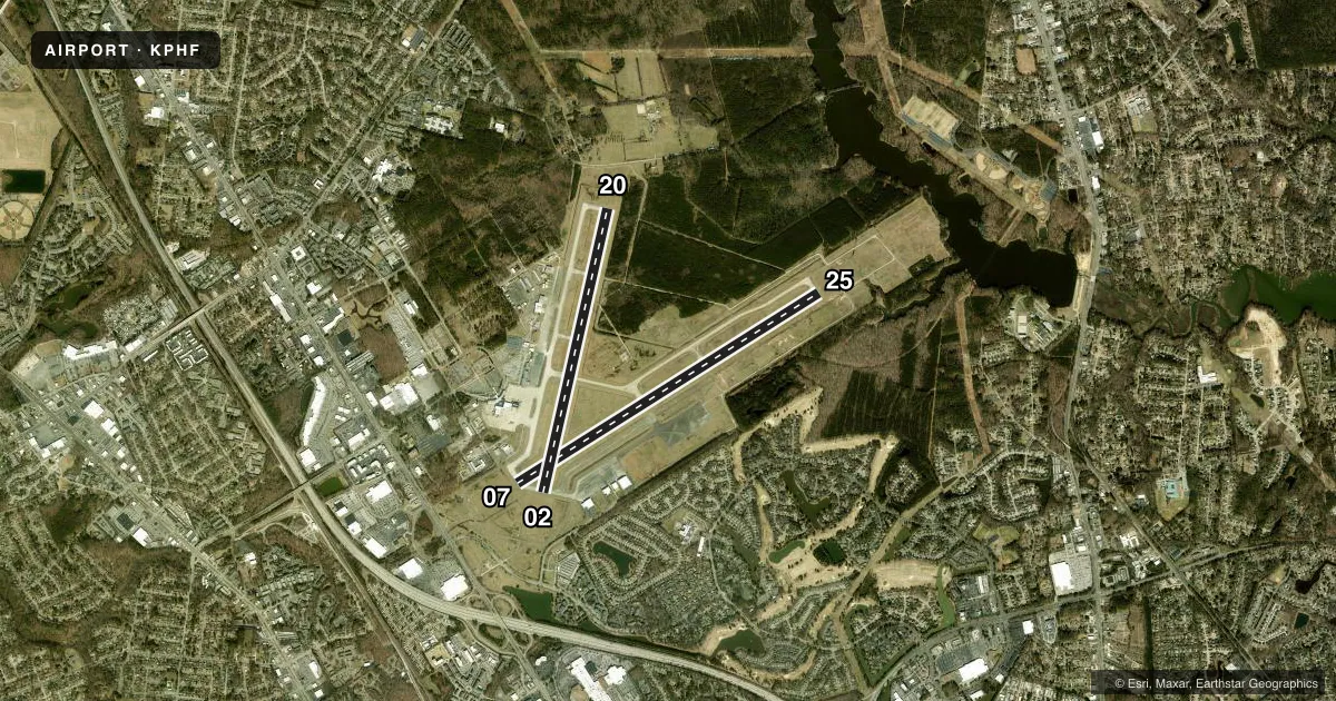
Runways & pattern
Full pagePattern entry · RWY 07
LEFT TRAFFIC| Runway | Heading (°M) | Length | Surface | Traffic |
|---|---|---|---|---|
| 07/25Favored | 49° / 229° | 8,003 ft | ASPH | Standard L |
| 02/20 | 4° / 184° | 6,526 ft | CONC | Standard L |
Runway end performance
| End | TORA | TODA | ASDA | LDA | VGSI | Approach lights | Obstruction |
|---|---|---|---|---|---|---|---|
| 07 | 8,003' | 8,003' | 8,003' | 8,003' | — | MALSR | 69', trees, 2700' from thr, 350' R of cntrln, slope 36 |
| 25 | 8,003' | 8,003' | 8,003' | 8,003' | PAPI 4-box right(3°) | — | 41', trees, 1100' from thr, 300' R of cntrln, slope 21 |
| 02 | 6,526' | 6,526' | 6,526' | 6,526' | PAPI 4-box left(3°) | — | — |
| 20 | 6,526' | 6,526' | 6,526' | 6,526' | PAPI 4-box left(3°) | — | 23', road, 1050' from thr, 0' R of cntrln, slope 36 |
Declared distances in feet. TORA = takeoff run available, TODA = takeoff distance, ASDA = accelerate-stop, LDA = landing distance.
Airport sketch
Runways drawn to scale from FAA survey coordinates, rendered over satellite imagery. Not for navigation.
Approaches & charts
ILS · 3
Services on the field
Fuel grades, oxygen, maintenance, ramp storage and lighting — as declared to the FAA by the airport operator.
Fuel & services
- Fuel
- 100LLA
- Oxygen (bottled)
- Low pressure
- Oxygen (bulk)
- Not available
- Airframe repair
- Major
- Power plant repair
- Major
- Other services
- AVNCS,CARGO,CHTR,INSTR,RNTL,SALES
Ramp & ground
- Transient storage
- Tie-down
- Hangar
- Landing fee
- Yes
- Customs
- Not available
- Lighting schedule
- SEE RMK
- Beacon schedule
- SS-SR
- Beacon
- White / Green (civil land)(WG)
- Wind indicator
- Lighted
- Segmented circle
- No
Fuel & FBOs
Cheapest 100LL and Jet A on the field and nearby. Always confirm with the FBO before taxi.
Airport notes
Surface conditions, obstructions, local procedures, lighting outages and other notes published with each FAA cycle.
General notes
- BIRDS INVOF ARPT.
- GLIDER ACTIVITY APPROX 19 MILES SW OF ARPT UP TO BASE OF CLOUDS.
- ACFT ARRIVING/DEPARTING NEWPORT NEWS SHOULD ANNOUNCE INTENTIONS ON CTAF WHEN ATCT CLSD.
- RMKS: RC PARK APRXLY 2 MILES N OF ARPT, UP TO 400 FT.
- RMKS: USE CTN LOW LVL HEL INVOF ARPT.
- INTMT AIRFIELD MOWING OPS APR-NOV.
- ARFF INDEX B COVERAGE PRVDD DURG SKED COML ACFT OPS.
Lighting notes
- ACTVT MALSR RWY 07; REIL RWY 20 & 25; PAPI RWY 02, 20 & 25; HIRL RWY 02/20 & 07/25; TWY LGTS - CTAF.
Runway surface & condition
- 02/20PCR VALUE: 540/R/C/W/U
- 07/25PCR VALUE: 628/F/B/W/U
Approach & departure obstructions
- 07MALSR UNMONITORED.
Other notes
- IN OPERATION PRIOR 1959.
- PPR 45 MINS FOR UNSKED ACR OPNS WITH MORE THAN 30 PSGR SEATS CALL ARPT OPS 757-957-2887.
- LANDING FEE FOR ACFT OVER 12500 LBS.
- 02/20(CONC-GRVD FM AER 20 TO 5000 FT. REMAINDER ASPHALT-GRVD)
VFR map & nearby airports
VFR sectional. Tap any ICAO chip to open that airport.
Key facts · KPHF
Answer card- ICAO
- KPHF
- Name
- NEWPORT NEWS/WILLIAMSBURG INTL
- Location
- NEWPORT NEWS, VIRGINIA
- Elevation
- 42.2 ft MSL
- Traffic pattern altitude
- 1,042.2 ft MSL (1,000 AGL)
- Control tower
- Towered · 0600-2300
- Total runways
- 2
- Longest runway
- 07/25 · 8,003 ft
- Published ILS approaches
- 3
- Published frequencies
- 16
- Magnetic variation
- 9°
- Current flight rules
- VFR
- Current wind
- 080° at 4 kt
- Favored runway now
- RWY 07
Newport News/Williamsburg Intl is in Newport News, Virginia. Field elevation is 42.2 ft MSL. The airport has 2 runways. The longest is 07/25 at 8,003 ft. The tower is open 0600-2300. Three ILS approaches are published here. Runway ends 07, 20 and 25 are served.
Pattern altitude is not published in the facts. Use 1,000 ft AGL for light piston traffic unless the current FAA Chart Supplement says otherwise. Atlantic Aviation is on the field. It carries 100LL and Jet A. Rick Aviation is also on the field. It carries 100LL and Jet A Prist. The airport has been in operation since before 1959. Birds are reported in the vicinity. Intermittent mowing can happen from April through November.
Runway 07 has medium intensity approach lighting with runway alignment indicator lights. That system is unmonitored. Runway 20 and runway 25 have runway end identifier lights. Precision approach path indicators are available on 02, 20 and 25. High intensity runway lights are installed on both runways. Runway 02/20 has concrete grooving from the aerodrome reference point to 5,000 ft. The rest is asphalt grooved. This is a busy controlled field near the coast, so plan for towered operations when the tower is open. When it is closed, announce intentions on CTAF.