METAR & TAF KSFQ
Current METAR
Observed 06:15Z
KSFQ 270615Z AUTO 00000KT 10SM SCT090 20/19 A2988 RMK AO2 T02030186
- Wind
- 000° @ 0 kt
- Visibility
- 10 SM
- Temp / Dew
- 20°C / 19°C
- Altimeter
- 29.88 inHg
- Clouds
- SCT
- Density alt
- 737 ft
- Ceiling
- Unlimited
- Rules
- VFR
Airport info & contacts
Manager on record, flight service, ARTCC, attendance schedule and pattern altitude — published by the FAA and refreshed every 28 days.
Location
- From city
- 3 NM SW
- VFR sectional
- WASHINGTON
- ARTCC
- ZDC · WASHINGTON
- NOTAM facility
- SFQ (NOTAM-D)
Airport manager
- Name
- TIM DANIEL
- Phone
- 757-514-4411
- Address
- 1200 GENE BOLTON DRIVE, SUFFOLK VA 23434
Flight service · Hours
- FSS DCA
- LEESBURG1-800-WX-BRIEF
- Attendance
- 0800-1700
Frequencies
Tap any row to copy the frequency to your clipboard.
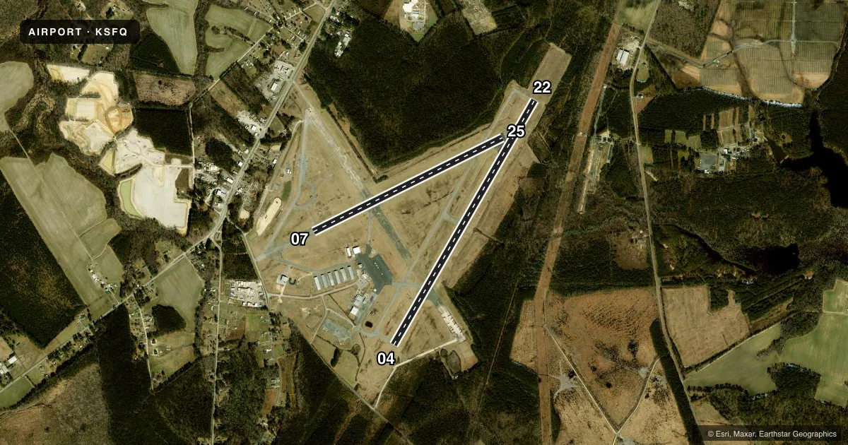
Runways & pattern
Full pagePattern entry · RWY 04
RIGHT TRAFFIC| Runway | Heading (°M) | Length | Surface | Traffic |
|---|---|---|---|---|
| 04/22 | 20° / 200° | 5,007 ft | ASPH | 04 R |
| 07/25 | 54° / 234° | 3,750 ft | ASPH | 25 R |
Runway end performance
| End | TORA | TODA | ASDA | LDA | VGSI | Approach lights | Obstruction |
|---|---|---|---|---|---|---|---|
| 04 | — | — | — | — | PAPI 4-box left(3°) | — | 23', tree, 820' from thr, 281' R of cntrln, slope 26 |
| 22 | — | — | — | — | PAPI 4-box left(3.5°) | — | 97', trees, 2317' from thr, 195' R of cntrln, slope 21 |
| 07 | — | — | — | — | — | — | 85', tree, 1904' from thr, 163' R of cntrln, slope 20 |
| 25 | — | — | — | — | — | — | 64', trees, 928' from thr, 254' R of cntrln, slope 11 |
Declared distances in feet. TORA = takeoff run available, TODA = takeoff distance, ASDA = accelerate-stop, LDA = landing distance.
Airport sketch
Runways drawn to scale from FAA survey coordinates, rendered over satellite imagery. Not for navigation.
Approaches & charts
ILS · 1
Services on the field
Fuel grades, oxygen, maintenance, ramp storage and lighting — as declared to the FAA by the airport operator.
Fuel & services
- Fuel
- 100LLAMOGAS
- Oxygen (bottled)
- Not available
- Oxygen (bulk)
- Not available
- Airframe repair
- Major
- Power plant repair
- Major
- Other services
- AGRI,CHTR,INSTR,PAJA,RNTL
Ramp & ground
- Transient storage
- Tie-down
- Landing fee
- No fee published
- Customs
- Not available
- Lighting schedule
- SEE RMK
- Beacon schedule
- SS-SR
- Beacon
- White / Green (civil land)(WG)
- Wind indicator
- Lighted
- Segmented circle
- Yes
Fuel & FBOs
Cheapest 100LL and Jet A on the field and nearby. Always confirm with the FBO before taxi.
Airport notes
Surface conditions, obstructions, local procedures, lighting outages and other notes published with each FAA cycle.
General notes
- DEER ON & INVOF ARPT.
- FOR CD CTC NORFOLK APCH AT 757-464-0757.
Lighting notes
- ACTVT REIL RWY 04 & 22; HIRL RWY 04/22 - CTAF.
Approach & departure obstructions
- 2212 FT TREE; 110 FT FM THLD, 220 RIGHT OF CNTRLN ON APCH CLNC SLP 9:1.
- 07RWY 7 MARKINGS FADED AND POOR CONDITION.
- 25RWY 25 MARKINGS IN POOR CONDITION.
- 07RWY END ARROW HEADS PAINTED WHITE INSTEAD OF DESIGNED AVIATION YELLOW.
Other notes
- IN OPERATION PRIOR 1959.
- AGRIPARACHUTE ACTIVITY ON & INVOF ARPT.
VFR map & nearby airports
VFR sectional. Tap any ICAO chip to open that airport.
Key facts · KSFQ
Answer card- ICAO
- KSFQ
- Name
- SUFFOLK EXEC
- Location
- SUFFOLK, VIRGINIA
- Elevation
- 70.1 ft MSL
- Traffic pattern altitude
- 1,070.1 ft MSL (1,000 AGL)
- Control tower
- Non-towered (use CTAF)
- Total runways
- 2
- Longest runway
- 04/22 · 5,007 ft
- Published ILS approaches
- 1
- Published frequencies
- 4
- Magnetic variation
- 10°
- Current flight rules
- VFR
- Current wind
- 000° at 0 kt
- Favored runway now
- –
Suffolk Executive Airport sits in Suffolk, Virginia. Field elevation is 70.1 ft MSL. The airport has two asphalt runways. The longest is runway 04/22 at 5,007 ft. There is no control tower. The published pattern altitude is not listed. Use the standard 1,000 ft AGL pattern for light piston traffic unless the current Chart Supplement says otherwise.
Runway 04 has an ILS approach. Norfolk Approach handles clearance delivery. The published remarks matter here. Deer are on and near the airport. Parachute activity also occurs on and in the vicinity of the field. Runway 04 and 22 have active end identifier lights. High intensity runway lights on 04 and 22 are controlled by CTAF. Runway 07 markings are faded and in poor condition. Runway 25 markings are also in poor condition. A 12-foot tree sits near the runway 22 approach path.
Suffolk Executive Airport has one on-field FBO. Suffolk Executive Airport carries 100LL, Jet A, Prist and MOGAS. For a first-time arrival, plan for an uncontrolled field with local traffic on CTAF 122.7. Watch for mixed traffic, including parachute operations. Check the current FAA Chart Supplement for any updated procedures before you go.