METAR & TAF KORF
Current METAR
Observed 05:51Z
KORF 270551Z AUTO 20008KT 10SM FEW100 21/18 A2987 RMK AO2 SLP114 T02110183 10244 20211 58008
- Wind
- 200° @ 8 kt
- Visibility
- 10 SM
- Temp / Dew
- 21°C / 18°C
- Altimeter
- 29.87 inHg
- Clouds
- FEW
- Density alt
- 814 ft
- Ceiling
- Unlimited
- Rules
- VFR
Airport info & contacts
Manager on record, flight service, ARTCC, attendance schedule and pattern altitude — published by the FAA and refreshed every 28 days.
Location
- From city
- 3 NM NE
- VFR sectional
- WASHINGTON
- ARTCC
- ZDC · WASHINGTON
- NOTAM facility
- ORF (NOTAM-D)
Airport manager
- Name
- MARK PERRYMAN
- Phone
- 757-857-3344
- Address
- 2200 NORVIEW AVE, NORFOLK VA 23518-5807
Flight service · Hours
- FSS DCA
- LEESBURG1-800-WX-BRIEF
- Attendance
- ALL
Frequencies
Tap any row to copy the frequency to your clipboard.
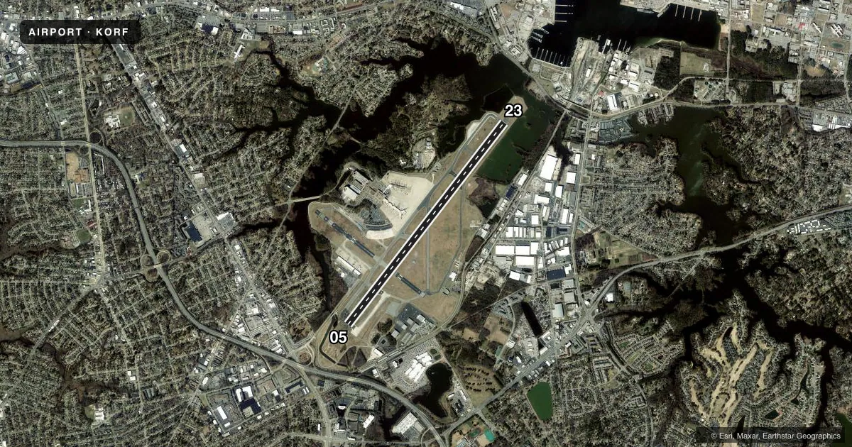
Runways & pattern
Full pagePattern entry · RWY 23
LEFT TRAFFICRunway end performance
| End | TORA | TODA | ASDA | LDA | VGSI | Approach lights | Obstruction |
|---|---|---|---|---|---|---|---|
| 05 | 9,001' | 9,001' | 8,809' | 7,809' | PAPI 4-box left(3°) | MALSR | 41', trees, 2100' from thr, 380' R of cntrln, slope 46 |
| 23 | 9,001' | 9,001' | 8,995' | 8,995' | PAPI 4-box left(3°) | MALSR | 49', pole, 1500' from thr, 150' R of cntrln, slope 26 |
Declared distances in feet. TORA = takeoff run available, TODA = takeoff distance, ASDA = accelerate-stop, LDA = landing distance.
Airport sketch
Runways drawn to scale from FAA survey coordinates, rendered over satellite imagery. Not for navigation.
Approaches & charts
ILS · 2
Services on the field
Fuel grades, oxygen, maintenance, ramp storage and lighting — as declared to the FAA by the airport operator.
Fuel & services
- Fuel
- 100LLA
- Oxygen (bottled)
- Low pressure
- Oxygen (bulk)
- HIGH/LOW
- Airframe repair
- Minor
- Power plant repair
- Minor
- Other services
- AVNCS,CARGO,CHTR,INSTR
Ramp & ground
- Transient storage
- Tie-down
- Hangar
- Landing fee
- Yes
- Customs
- Not available
- Lighting schedule
- SS-SR
- Beacon schedule
- SS-SR
- Beacon
- White / Green (civil land)(WG)
- Wind indicator
- Lighted
- Segmented circle
- No
Fuel & FBOs
Cheapest 100LL and Jet A on the field and nearby. Always confirm with the FBO before taxi.
Airport notes
Surface conditions, obstructions, local procedures, lighting outages and other notes published with each FAA cycle.
General notes
- NOISE ABATEMENT PROCEDURES IN EFFECT.
- FLOCKS OF BIRDS ON & INVOF ARPT.
- INTMT AIRFIELD MOWING OPS MAR - NOV.
Runway surface & condition
- 05/23PCR VALUE: 630/F/A/X/T
Approach & departure obstructions
- 23RWY 23 +1 FT FENCE 80 FT FM RWY END 400 FT R 10 FT FENCE 0-200 270 FT L.
- 05APCH RATIO 50:1 TO DSPLCD THR.
Other notes
- MANAGERPOLICE DISPATCH.
- 05/23CONC PTNS: LONGL CRACKS & SPALLING.
VFR map & nearby airports
VFR sectional. Tap any ICAO chip to open that airport.
Key facts · KORF
Answer card- ICAO
- KORF
- Name
- NORFOLK INTL
- Location
- NORFOLK, VIRGINIA
- Elevation
- 26.2 ft MSL
- Traffic pattern altitude
- 1,026.2 ft MSL (1,000 AGL)
- Control tower
- Towered · 24
- Total runways
- 1
- Longest runway
- 05/23 · 9,001 ft
- Published ILS approaches
- 2
- Published frequencies
- 17
- Magnetic variation
- 9°
- Current flight rules
- VFR
- Current wind
- 200° at 8 kt
- Favored runway now
- RWY 23
Norfolk Intl is in Norfolk, Virginia. Field elevation is 26.4 ft MSL. The airport has 2 runways. The longest is 9,001 ft on 05/23. The tower is open 24 hours. There are 2 ILS approaches, both tied to runway ends 05 and 23.
Pattern altitude is not published in the facts. Use 1,000 ft AGL for light piston traffic unless ATC or the current Chart Supplement gives a different instruction. Signature Aviation is on the field. It carries AVGAS 100LL and Jet A. Call (757) 857-3463 for current service details.
A few published remarks matter here. Noise abatement procedures are in effect. Birds are reported on and near the airport, so keep a sharp scan on departure and arrival. Runway 14/32 is closed indefinitely. The remaining pavement on 05/23 has reported cracking and spalling in the concrete sections, so expect a worn surface. There are also obstruction notes near the displaced thresholds on 05 and 14, plus fencing near the far end of 23. This is a busy controlled field in Class C airspace. Get the current clearance. Brief the ILS if you plan to use it. Be ready for tower instructions.