METAR & TAF KAKQ
Current METAR
Observed 07:54Z
KAKQ 270754Z AUTO 00000KT 9SM OVC075 21/19 A2985 RMK AO2 SLP109 T02060189
- Wind
- 000° @ 0 kt
- Visibility
- 9 SM
- Temp / Dew
- 21°C / 19°C
- Altimeter
- 29.85 inHg
- Clouds
- OVC
- Density alt
- 945 ft
- Ceiling
- 7,500 ft AGL
- Rules
- VFR
Airport info & contacts
Manager on record, flight service, ARTCC, attendance schedule and pattern altitude — published by the FAA and refreshed every 28 days.
Location
- From city
- 2 NM NW
- VFR sectional
- WASHINGTON
- ARTCC
- ZDC · WASHINGTON
- NOTAM facility
- AKQ (NOTAM-D)
Airport manager
- Name
- BRIAN LAINE
- Phone
- 757-899-0096
- Address
- P.O. BOX 550, WAKEFIELD VA 23888
Flight service · Hours
- FSS DCA
- LEESBURG1-800-WX-BRIEF
- Attendance
- IREG
Frequencies
Tap any row to copy the frequency to your clipboard.
Runways & pattern
Full pagePattern entry · RWY 03
LEFT TRAFFICRunway end performance
| End | TORA | TODA | ASDA | LDA | VGSI | Approach lights | Obstruction |
|---|---|---|---|---|---|---|---|
| 03 | — | — | — | — | — | — | 28', trees, 201' from thr, 52' R of cntrln, slope 0 |
| 21 | — | — | — | — | — | — | 62', trees, 1154' from thr, 34' R of cntrln, slope 15 |
Declared distances in feet. TORA = takeoff run available, TODA = takeoff distance, ASDA = accelerate-stop, LDA = landing distance.
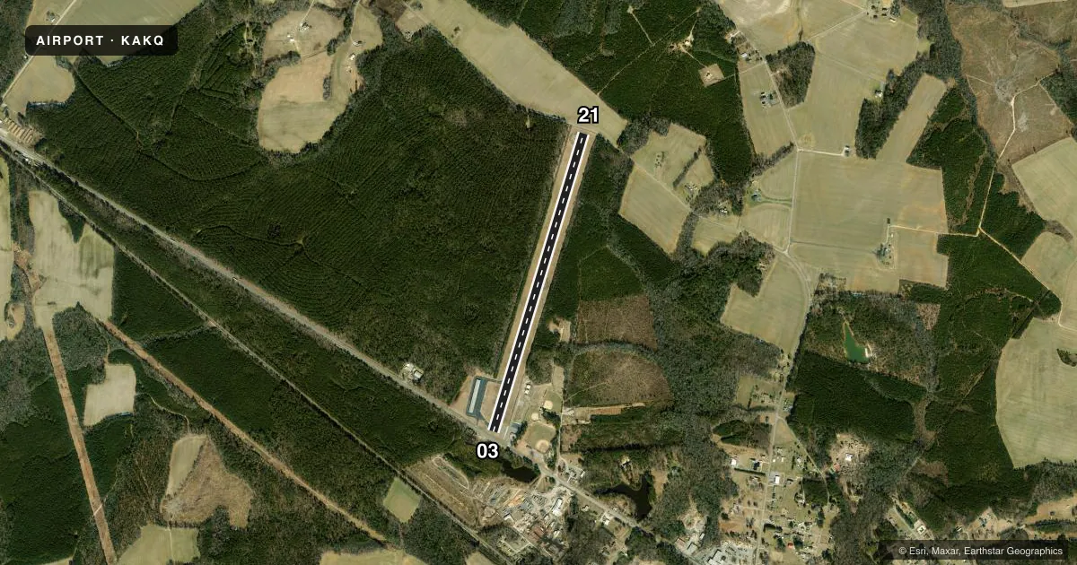
Airport sketch
Runways drawn to scale from FAA survey coordinates, rendered over satellite imagery. Not for navigation.
Approaches & charts
Services on the field
Fuel grades, oxygen, maintenance, ramp storage and lighting — as declared to the FAA by the airport operator.
Fuel & services
- Fuel
- 100LL
- Oxygen (bottled)
- Not available
- Oxygen (bulk)
- Not available
- Airframe repair
- Not available
- Power plant repair
- Not available
- Other services
- AGRI
Ramp & ground
- Transient storage
- Tie-down
- Hangar
- Landing fee
- No fee published
- Customs
- Not available
- Beacon schedule
- SS-SR
- Beacon
- White / Green (civil land)(WG)
- Wind indicator
- Lighted
- Segmented circle
- Yes
Fuel & FBOs
Cheapest 100LL and Jet A on the field and nearby. Always confirm with the FBO before taxi.
Airport notes
Surface conditions, obstructions, local procedures, lighting outages and other notes published with each FAA cycle.
General notes
- FOR CD CTC NORFOLK APCH AT 757-464-0757.
Fuel notes
- 100LL24 HR SELF SERVICE FUEL.
Approach & departure obstructions
- 03RD +15' 70' FM THR CROSSING END.
- 21ROAD +15 FT 70 FT FM RY END.
- 03RWY 03 MRKGS CVRD WITH ALGAE.
- 21RWY 21 MRKGS CVRD WITH ALGAE.
- 03CTLNG OBSTN EXCEEDS A 45 DEG SLP, CLNC SLP TO DSPLCD THLD 8:1.
- 21CLNC SLP TO DSPLCD THLD 22:1.
VFR map & nearby airports
VFR sectional. Tap any ICAO chip to open that airport.
Key facts · KAKQ
Answer card- ICAO
- KAKQ
- Name
- WAKEFIELD MUNI
- Location
- WAKEFIELD, VIRGINIA
- Elevation
- 111.4 ft MSL
- Traffic pattern altitude
- 1,111.4 ft MSL (1,000 AGL)
- Control tower
- Non-towered (use CTAF)
- Total runways
- 1
- Longest runway
- 03/21 · 4,337 ft
- Published ILS approaches
- 0
- Published frequencies
- 4
- Magnetic variation
- 11°
- Current flight rules
- VFR
- Current wind
- 000° at 0 kt
- Favored runway now
- –
Wakefield Muni sits in Wakefield, Virginia. Field elevation is 111.4 ft MSL. The airport has one runway. Runway 03/21 is 4,337 ft long, so plan your performance with that single strip in mind.
There is no control tower. CTAF and UNICOM are both 122.8. Norfolk Approach handles clearance delivery and approach or departure work on 127.9 or 269.425. No ILS approaches are published here. The pattern altitude is not published, so use the standard 1,000 ft AGL for light piston traffic unless the current Chart Supplement says otherwise.
Wakefield Municipal Airport is the on-field FBO. It carries 100LL. Twenty-four hour self-serve fuel is available. That is useful if you are working an early arrival or a late departure.
The published remarks matter here. Runway 03 and 21 markings are reported covered with algae. There are also obstacle notes near both thresholds. The clearance slopes to the displaced thresholds are tight, so give yourself a careful look at the runway environment before landing. For a first-time arrival, expect an uncontrolled field with Norfolk Approach coordination and review the current Chart Supplement before you go.