METAR & TAF KEMV
Current METAR
Observed 12:35Z
KEMV 271235Z AUTO 00000KT 10SM 22/20 A2988 RMK AO2 T02170201
- Wind
- 000° @ 0 kt
- Visibility
- 10 SM
- Temp / Dew
- 22°C / 20°C
- Altimeter
- 29.88 inHg
- Clouds
- Clear
- Density alt
- 1,047 ft
- Ceiling
- Unlimited
- Rules
- VFR
Airport info & contacts
Manager on record, flight service, ARTCC, attendance schedule and pattern altitude — published by the FAA and refreshed every 28 days.
Location
- From city
- 3 NM E
- VFR sectional
- WASHINGTON
- ARTCC
- ZDC · WASHINGTON
- NOTAM facility
- EMV (NOTAM-D)
Airport manager
- Name
- BARBARA MOORE
- Phone
- 434-634-3696
- Address
- 139 AIRPORT DR., EMPORIA VA 23847
Flight service · Hours
- FSS DCA
- LEESBURG1-800-WX-BRIEF
- Attendance
- 0900-1700
Frequencies
Tap any row to copy the frequency to your clipboard.
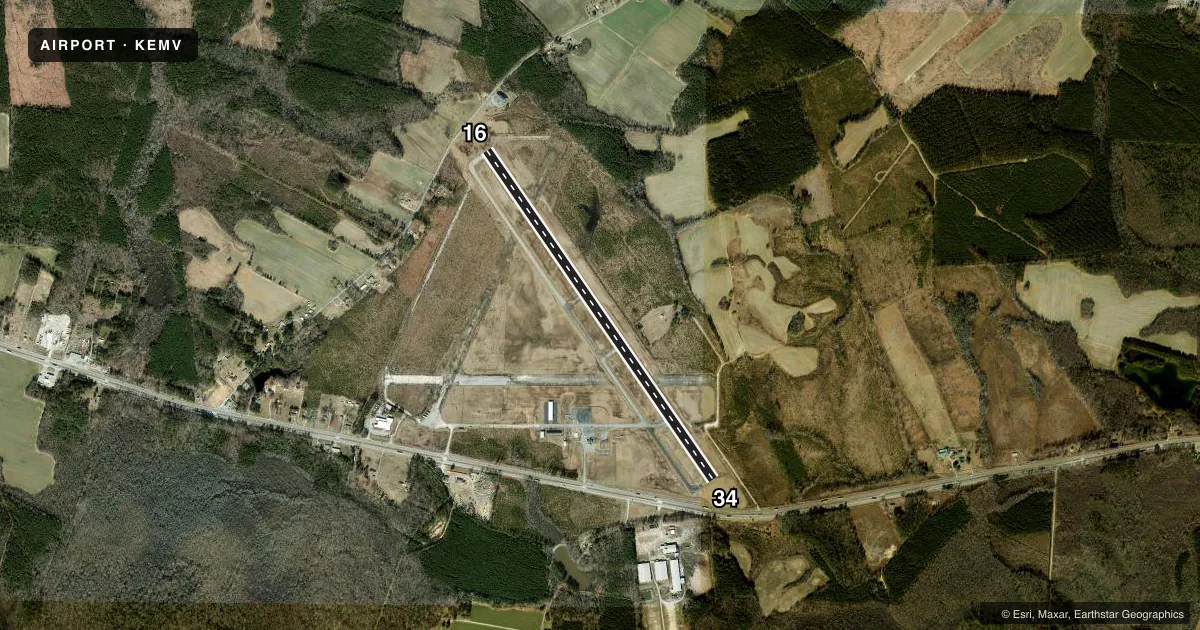
Runways & pattern
Full pagePattern entry · RWY 16
LEFT TRAFFICRunway end performance
| End | TORA | TODA | ASDA | LDA | VGSI | Approach lights | Obstruction |
|---|---|---|---|---|---|---|---|
| 16 | — | — | — | — | PAPI 2-box left(3°) | — | 15', road, 336' from thr, 263' R of cntrln, slope 9 |
| 34 | — | — | — | — | PAPI 2-box left(3°) | — | 34', tree, 699' from thr, 281' R of cntrln, slope 14 |
Declared distances in feet. TORA = takeoff run available, TODA = takeoff distance, ASDA = accelerate-stop, LDA = landing distance.
Airport sketch
Runways drawn to scale from FAA survey coordinates, rendered over satellite imagery. Not for navigation.
Approaches & charts
ILS · 1
Services on the field
Fuel grades, oxygen, maintenance, ramp storage and lighting — as declared to the FAA by the airport operator.
Fuel & services
- Fuel
- 100LLA
- Oxygen (bottled)
- Not available
- Oxygen (bulk)
- Not available
- Other services
- AGRI
Ramp & ground
- Transient storage
- Tie-down
- Hangar
- Landing fee
- No fee published
- Customs
- Not available
- Lighting schedule
- SEE RMK
- Beacon schedule
- SS-SR
- Beacon
- White / Green (civil land)(WG)
- Wind indicator
- Lighted
- Segmented circle
- Yes
Fuel & FBOs
Cheapest 100LL and Jet A on the field and nearby. Always confirm with the FBO before taxi.
Airport notes
Surface conditions, obstructions, local procedures, lighting outages and other notes published with each FAA cycle.
General notes
- DEER ON & INVOF ARPT.
- FOR CD CTC WASHINGTON ARTCC AT 703-771-3587.
Lighting notes
- ACTIVATE REIL RWY 16 & 34; MIRL RWY 16/34 - CTAF. PAPI RWY 16 & 34 OPR CONSLY.
Approach & departure obstructions
- 16RWY 16 PAPI UNUSBL BYD 7 DEG LEFT & RIGHT OF CNTRLN.
- 34RWY 34 PAPI UNUSBL BYD 8 DEG RIGHT OF CNTRLN.
Other notes
- PRIOR TO 1959.
- TPA LGT ACFT 1000 FT, HVY ACFT 1500 FT.
VFR map & nearby airports
VFR sectional. Tap any ICAO chip to open that airport.
Key facts · KEMV
Answer card- ICAO
- KEMV
- Name
- EMPORIA-GREENSVILLE RGNL
- Location
- EMPORIA, VIRGINIA
- Elevation
- 126.7 ft MSL
- Traffic pattern altitude
- 1,126.7 ft MSL (1,000 AGL)
- Control tower
- Non-towered (use CTAF)
- Total runways
- 1
- Longest runway
- 16/34 · 5,010 ft
- Published ILS approaches
- 1
- Published frequencies
- 2
- Magnetic variation
- 10°
- Current flight rules
- VFR
- Current wind
- 000° at 0 kt
- Favored runway now
- –
Emporia-Greensville Regional Airport sits in Emporia, Virginia. The field elevation is 126.7 ft MSL. It has one runway, 16/34, at 5,010 ft. There is no control tower. CTAF and UNICOM are both 123.0. The airport has one ILS approach for runway 34. The published pattern altitude is 1,000 ft AGL for light aircraft. Heavy aircraft use 1,500 ft AGL.
The on-field FBO is Emporia-Greensville Regional Airport. It carries 100LL and Jet A. Call (434) 634-3696 for current service details before you go. Published remarks note deer on and near the airport, so keep a sharp scan on taxi, takeoff and landing. Lighting is pilot-controlled on CTAF. REIL is available on runways 16 and 34. MIRL is also activated via CTAF. The PAPI is on continuously. The runway 16 PAPI is unusable beyond 7 degrees left and right of centerline. The runway 34 PAPI is unusable beyond 8 degrees right of centerline.
For a first-time arrival, the big items are the non-towered setup, the single runway and the wildlife hazard. Use the published pattern altitude. Check the current FAA Chart Supplement for any updated remarks before departure. If you need clearance delivery, the published contact is Washington ARTCC at 703-771-3587.