METAR & TAF KBKT
Current METAR
Observed 11:55Z
KBKT 271155Z AUTO 31003KT 10SM CLR 22/21 A2986 RMK AO2 SLP111 60137 70137 T02240212 10230 20192 51005 $
- Wind
- 310° @ 3 kt
- Visibility
- 10 SM
- Temp / Dew
- 22°C / 21°C
- Altimeter
- 29.86 inHg
- Clouds
- CLR
- Density alt
- 1,457 ft
- Ceiling
- Unlimited
- Rules
- VFR
Airport info & contacts
Manager on record, flight service, ARTCC, attendance schedule and pattern altitude — published by the FAA and refreshed every 28 days.
Location
- From city
- 2 NM E
- VFR sectional
- WASHINGTON
- ARTCC
- ZDC · WASHINGTON
- NOTAM facility
- DCA (NOTAM-D)
Airport manager
- Name
- WALTER G. TISDALE
- Phone
- 434-292-2193
- Address
- 49 DOMINY CORNER ROAD, BLACKSTONE VA 23824
Flight service · Hours
- FSS DCA
- LEESBURG1-800-WX-BRIEF
- Attendance
- MON-FRI · 0800-1600
Frequencies
Tap any row to copy the frequency to your clipboard.
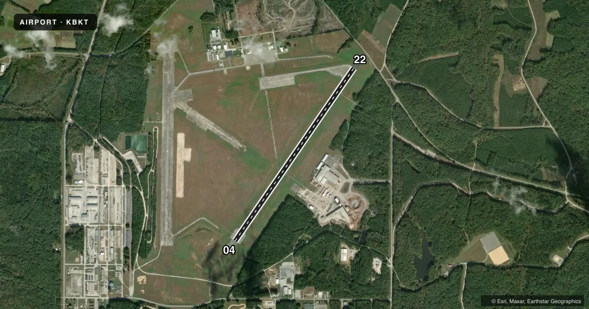
Runways & pattern
Full pagePattern entry · RWY 04
LEFT TRAFFICRunway end performance
| End | TORA | TODA | ASDA | LDA | VGSI | Approach lights | Obstruction |
|---|---|---|---|---|---|---|---|
| 04 | — | — | — | — | — | — | 82', tree, 1918' from thr, 478' R of cntrln, slope 20 |
| 22 | — | — | — | — | — | — | 62', tree, 1285' from thr, 245' R of cntrln, slope 17 |
Declared distances in feet. TORA = takeoff run available, TODA = takeoff distance, ASDA = accelerate-stop, LDA = landing distance.
Airport sketch
Runways drawn to scale from FAA survey coordinates, rendered over satellite imagery. Not for navigation.
Approaches & charts
Services on the field
Fuel grades, oxygen, maintenance, ramp storage and lighting — as declared to the FAA by the airport operator.
Fuel & services
- Fuel
- 100LLA
- Oxygen (bottled)
- Not available
- Oxygen (bulk)
- Not available
- Airframe repair
- Not available
- Power plant repair
- Not available
Ramp & ground
- Transient storage
- Tie-down
- Hangar
- Landing fee
- No fee published
- Customs
- Not available
- Lighting schedule
- SEE RMK
- Beacon schedule
- SS-SR
- Beacon
- White / Green (civil land)(WG)
- Wind indicator
- Lighted
- Segmented circle
- Yes
Fuel & FBOs
Cheapest 100LL and Jet A on the field and nearby. Always confirm with the FBO before taxi.
Airport notes
Surface conditions, obstructions, local procedures, lighting outages and other notes published with each FAA cycle.
General notes
- CTC PTS DIV FT PICKETT 434-292-2193/8622/2047 FOR PPR.
- JET AND MIL TRNG WITHIN 20 NM RADIUS. EXTN C130 TFC AND FREQ PRCHT DROPS.
- AVOID FLT BLW 500 FT OVR AMMUNITION SUP POINT 1 NM S OF ARPT.
- DEER AND BIRD WILDLIFE HAZ, CTC BASE OPS C434-292-8589 FOR CURRENT STATUS.
- NO PPR RQRD FOR CIV ACFT.
- SVC: C434-294-7558, OT 434-292-7251.
- APGU AVBL DURING DUTY HOURS.
- WHEN ATCT CLSD, FOR CD CTC WASHINGTON ARTCC AT 703-771-3587.
- EXTSV UAS ACTVY ON & INVOF OF ARPT.
- MILITARY: MISC: MIL ACFT CTC BASE OPS 434-292-8589/2193 FOR PPR. CRASH/RESCUE SVC 434-292-2217.
Lighting notes
- WHEN ATCT CLSD ACTVT MIRL RWY 04/22 - CTAF.
Runway surface & condition
- H1PRI INGRESS/EGRESS 277/097; SRY INGRESS/EGRESS 097/277. SFC MRKGS NSTD. DALGT USE ONLY. LTD TO 12500 LBS. USED EXTSVLY FOR UAS AND AAM TRNG AND TESTING. FATO IS NON-LOADBEARING.
Approach & departure obstructions
- 04RWY MARKINGS IN POOR COND.
- 22RWY MARKINGS IN POOR COND. DSPLCD THR POOR VIS. HOLD SHORT LINE POOR VIS.
- 22OBSTN CLNC 23:1 AT DTHR.
Other notes
- IN OPN PRIOR 1959.
- ACFT ON FLD DURING SUMMER EXER.
- OWNERC/O PHILIP VANNOORBEECK TOWN MANAGER.
VFR map & nearby airports
VFR sectional. Tap any ICAO chip to open that airport.
Key facts · KBKT
Answer card- ICAO
- KBKT
- Name
- ALLAN C PERKINSON/BLACKSTONE AAF
- Location
- BLACKSTONE, VIRGINIA
- Elevation
- 437.4 ft MSL
- Traffic pattern altitude
- 1,437.4 ft MSL (1,000 AGL)
- Control tower
- Towered · MON-FRI 1300-2100Z++; EXC FED HOLS; OT BY NOTAM.
- Total runways
- 1
- Longest runway
- 04/22 · 5,333 ft
- Published ILS approaches
- 0
- Published frequencies
- 7
- Magnetic variation
- 9°
- Current flight rules
- VFR
- Current wind
- 310° at 3 kt
- Favored runway now
- RWY 04
Allan C Perkinson/Blackstone AAF is in Blackstone, Virginia. The field elevation is 437.4 ft MSL. It has one runway, 04/22, which is 5,333 ft long and paved concrete. The tower is open Monday through Friday from 1300 to 2100Z, except federal holidays. It can also be open by NOTAM. No ILS approaches are published here.
Pattern altitude is not published. Use the standard 1,000 ft AGL for light piston operations unless the current Chart Supplement says otherwise. Partner Aviation is on the field. It carries 100LL and Jet A. Call them at (434) 292-4914 for current service details.
A few operational notes matter here. Runway 22 markings are in poor condition. The displaced threshold and hold short line are also hard to see. There is an obstacle clearance slope at the displaced threshold for 22. Wildlife is a factor too. Deer and bird activity has been reported. Jet and military training also happens within 20 NM, with C130 traffic and parachute drops expected. When the tower is closed, use CTAF 134.7 to activate the medium intensity runway lights on 04/22. For current permission and field status, contact the base operations numbers in the Chart Supplement before arrival.