METAR & TAF KCXE
Current METAR
Observed 15:15Z
KCXE 271515Z AUTO 36004KT 10SM SCT027 27/21 A2989 RMK AO1 T02720206
- Wind
- 360° @ 4 kt
- Visibility
- 10 SM
- Temp / Dew
- 27°C / 21°C
- Altimeter
- 29.89 inHg
- Clouds
- SCT
- Density alt
- 2,101 ft
- Ceiling
- Unlimited
- Rules
- VFR
Airport info & contacts
Manager on record, flight service, ARTCC, attendance schedule and pattern altitude — published by the FAA and refreshed every 28 days.
Location
- From city
- 2 NM W
- VFR sectional
- WASHINGTON
- Pattern altitude
- 800 ft AGL · 1,303 ft MSL
- ARTCC
- ZDC · WASHINGTON
- NOTAM facility
- DCA (NOTAM-D)
Airport manager
- Name
- CHARLES FORBES
- Phone
- 434-372-5136
- Address
- 319 N MAIN ST, CHASE CITY VA 23924
Flight service · Hours
- FSS DCA
- LEESBURG1-800-WX-BRIEF
- Attendance
- UNATTENDED
Frequencies
Tap any row to copy the frequency to your clipboard.
Runways & pattern
Full pagePattern entry · RWY 36
LEFT TRAFFICRunway end performance
| End | TORA | TODA | ASDA | LDA | VGSI | Approach lights | Obstruction |
|---|---|---|---|---|---|---|---|
| 18 | — | — | — | — | — | — | 23', road, 200' from thr, 108' R of cntrln, slope 0 |
| 36 | — | — | — | — | — | — | 31', brush, 247' from thr, 115' R of cntrln, slope 1 |
Declared distances in feet. TORA = takeoff run available, TODA = takeoff distance, ASDA = accelerate-stop, LDA = landing distance.
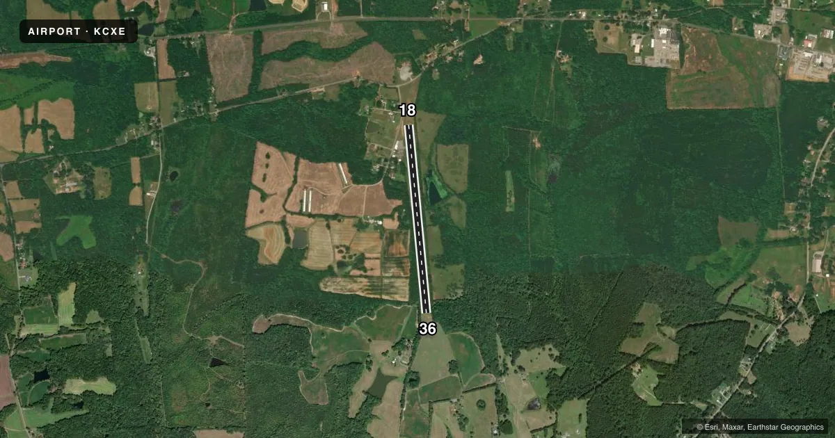
Airport sketch
Runways drawn to scale from FAA survey coordinates, rendered over satellite imagery. Not for navigation.
Approaches & charts
Services on the field
Fuel grades, oxygen, maintenance, ramp storage and lighting — as declared to the FAA by the airport operator.
Fuel & services
- Fuel
- Not available
- Oxygen (bottled)
- Not available
- Oxygen (bulk)
- Not available
Ramp & ground
- Transient storage
- Tie-down
- Landing fee
- No fee published
- Customs
- Not available
- Wind indicator
- Yes
- Segmented circle
- No
Fuel & FBOs
Cheapest 100LL and Jet A on the field and nearby. Always confirm with the FBO before taxi.
Airport notes
Surface conditions, obstructions, local procedures, lighting outages and other notes published with each FAA cycle.
General notes
- DEER ON & INVOF ARPT.
- FARM EQUIP OPERATING NEAR RWY.
- ARPT CLSD SS-SR INDEFLY.
- FOR CD CTC WASHINGTON ARTCC AT 703-771-3587.
Approach & departure obstructions
- 18+6 FT GND 115 FT R OF RWY END; +20 FT ROAD 100 FT FM THR, 125 FT R.
- 36RISING GND 150 FT FM RWY END; 30 FT TREES 100 FT BOTH SIDES OF CNTRLN.
- 18MARKINGS SEVERELY FADED
- 36MARKINGS SEVERELY FADED
- 18MARKINGS SEVERELY FADED AND RAVELING.
- 36MARKINGS SEVERELY FADED AND RAVELING.
Other notes
- THIS AIRPORT HAS BEEN SURVEYED BY THE NATIONAL GEODETIC SURVEY.
- MANAGERTOWN MANAGER.
- 18/36SEVERE RWY CRACKING. 1-2 INCHES IN PLACES AND ALG CNTRLN.
- 18/36LONGITUDINAL AND TRANSVERSE CRACKING. SOME RAVELING IN CERTAIN AREAS.
VFR map & nearby airports
VFR sectional. Tap any ICAO chip to open that airport.
Key facts · KCXE
Answer card- ICAO
- KCXE
- Name
- CHASE CITY MUNI
- Location
- CHASE CITY, VIRGINIA
- Elevation
- 503 ft MSL
- Traffic pattern altitude
- 1,303 ft MSL (800 AGL)
- Control tower
- Non-towered (use CTAF)
- Total runways
- 1
- Longest runway
- 18/36 · 3,400 ft
- Published ILS approaches
- 0
- Published frequencies
- 1
- Magnetic variation
- 9°
- Current flight rules
- VFR
- Current wind
- 360° at 4 kt
- Favored runway now
- RWY 36
Chase City Muni sits in Chase City, Virginia. Field elevation is 503 ft MSL. The airport has one runway. Runway 18/36 is 3,400 ft long and asphalt. There is no control tower. CTAF is 122.9. No ILS approaches are published.
Pattern altitude is 800 ft AGL, which is 1,303 ft MSL. That matters here because the field is closed from sunset to sunrise indefinitely. Plan your arrival in daylight and confirm current conditions before you go. The runway surface has cracking and some raveling. Runway 18 and Runway 36 markings are severely faded. Farm equipment operates near the runway. Deer are also reported on and near the airport.
The published remarks also call out obstructions near both ends. There is rising ground near the Runway 36 end. Trees are close to the centerline on both sides. A small ground obstruction and a road are near the Runway 18 end. This is a field where a careful preflight and a good look at the current Chart Supplement are smart. No on-field FBOs are listed, so verify fuel and services with the airport operator or by calling the field directly before arrival.