METAR & TAF KAVC
Current METAR
Observed 15:55Z
KAVC 271555Z AUTO 01005KT 10SM SCT026 28/21 A2994 RMK AO2 T02790212
- Wind
- 010° @ 5 kt
- Visibility
- 10 SM
- Temp / Dew
- 28°C / 21°C
- Altimeter
- 29.94 inHg
- Clouds
- SCT
- Density alt
- 2,083 ft
- Ceiling
- Unlimited
- Rules
- VFR
Airport info & contacts
Manager on record, flight service, ARTCC, attendance schedule and pattern altitude — published by the FAA and refreshed every 28 days.
Location
- From city
- 4 NM SE
- VFR sectional
- WASHINGTON
- Pattern altitude
- 1,400 ft AGL · 1,841 ft MSL
- ARTCC
- ZDC · WASHINGTON
- NOTAM facility
- AVC (NOTAM-D)
Airport manager
- Name
- JOHN ZUBROD
- Phone
- 434-774-8023
- Address
- 1495 REGIONAL AIRPORT RD, BRODNAX VA 23920-3520
Flight service · Hours
- FSS DCA
- LEESBURG1-800-WX-BRIEF
- Attendance
- 0800-1700
Frequencies
Tap any row to copy the frequency to your clipboard.
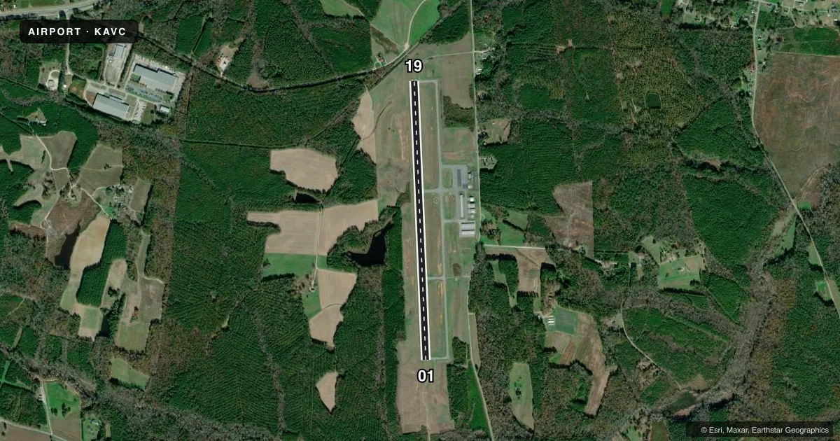
Runways & pattern
Full pagePattern entry · RWY 01
LEFT TRAFFICRunway end performance
| End | TORA | TODA | ASDA | LDA | VGSI | Approach lights | Obstruction |
|---|---|---|---|---|---|---|---|
| 01 | — | — | — | — | PAPI 2-box left(3°) | ODALS | 84', tree, 3069' from thr, 530' R of cntrln, slope 34 |
| 19 | — | — | — | — | PAPI 2-box left(3°) | — | 17', trees, 308' from thr, 258' R of cntrln, slope 6 |
Declared distances in feet. TORA = takeoff run available, TODA = takeoff distance, ASDA = accelerate-stop, LDA = landing distance.
Airport sketch
Runways drawn to scale from FAA survey coordinates, rendered over satellite imagery. Not for navigation.
Approaches & charts
ILS · 1
Services on the field
Fuel grades, oxygen, maintenance, ramp storage and lighting — as declared to the FAA by the airport operator.
Fuel & services
- Fuel
- 100LLA
- Oxygen (bottled)
- Not available
- Oxygen (bulk)
- Not available
- Airframe repair
- Minor
- Power plant repair
- Minor
- Other services
- INSTR,RNTL
Ramp & ground
- Transient storage
- Tie-down
- Lighting schedule
- SEE RMK
- Beacon schedule
- SS-SR
- Beacon
- White / Green (civil land)(WG)
- Wind indicator
- Lighted
- Segmented circle
- Yes
Fuel & FBOs
Cheapest 100LL and Jet A on the field and nearby. Always confirm with the FBO before taxi.
Airport notes
Surface conditions, obstructions, local procedures, lighting outages and other notes published with each FAA cycle.
General notes
- DEER & BIRDS ON & INVOF ARPT
- CORPORATE HANGER TAXILANE RESTRICTED TO AIRCRAFT WITH WINGSPAN NO LARGER THAN 55 FT.
- FOR CD CTC WASHINGTON ARTCC AT 703-771-3587.
Lighting notes
- ACTIVATE REIL RY 01/19; MIRL RY 01/19 PRESET LOW INTST; FOR HIGHER INTST & TO ACTVT ODALS - CTAF.
Fuel notes
- 100LL24 HR FUEL AVBL BY CREDIT CARD.
Other notes
- 1ARPT CLSD ON FED HOLS.
VFR map & nearby airports
VFR sectional. Tap any ICAO chip to open that airport.
Key facts · KAVC
Answer card- ICAO
- KAVC
- Name
- MECKLENBURG-BRUNSWICK RGNL
- Location
- SOUTH HILL, VIRGINIA
- Elevation
- 441.4 ft MSL
- Traffic pattern altitude
- 1,841.4 ft MSL (1,400 AGL)
- Control tower
- Non-towered (use CTAF)
- Total runways
- 1
- Longest runway
- 01/19 · 5,002 ft
- Published ILS approaches
- 1
- Published frequencies
- 2
- Magnetic variation
- 9°
- Current flight rules
- VFR
- Current wind
- 010° at 5 kt
- Favored runway now
- RWY 01
Mecklenburg-Brunswick RGNL is in South Hill, Virginia. Field elevation is 441.4 ft MSL. The airport has one runway, 01/19, which is 5,002 ft long. There is no control tower. CTAF and UNICOM are both 122.8. The field has one ILS approach to runway 01. Pattern altitude is 1,400 ft AGL, which is 1,841.4 ft MSL.
The on-field FBO is Mecklenburg-Brunswick Regional Airport. It carries 100LL and Jet A Prist. The remarks say 24-hour fuel is available by credit card. The airport is closed on federal holidays. For clearance delivery, contact Washington ARTCC at 703-771-3587.
A first-time pilot should pay attention to the runway lighting setup. Runway end identifier lights on 01/19 are activated from the CTAF. Medium intensity runway lights are preset to low intensity. Use the CTAF for higher intensity and to activate the omnidirectional approach lighting system. Deer and birds are reported on and near the airport. The corporate hangar taxilane is restricted to aircraft with wingspan no larger than 55 feet. Check the current FAA Chart Supplement for any published noise or curfew restrictions before flying into the field.