METAR & TAF KLVL
Current METAR
Observed 16:35Z
KLVL 271635Z AUTO 08003KT 10SM CLR 29/21 A2989 RMK AO1 T02860210
- Wind
- 080° @ 3 kt
- Visibility
- 10 SM
- Temp / Dew
- 29°C / 21°C
- Altimeter
- 29.89 inHg
- Clouds
- CLR
- Density alt
- 2,125 ft
- Ceiling
- Unlimited
- Rules
- VFR
Airport info & contacts
Manager on record, flight service, ARTCC, attendance schedule and pattern altitude — published by the FAA and refreshed every 28 days.
Location
- From city
- 3 NM E
- VFR sectional
- WASHINGTON
- ARTCC
- ZDC · WASHINGTON
- NOTAM facility
- DCA (NOTAM-D)
Airport manager
- Name
- ANDREW SYKES
- Phone
- 434-848-2767
- Address
- 77 AIRPORT DR, LAWRENCEVILLE VA 23868
Flight service · Hours
- FSS DCA
- LEESBURG1-800-WX-BRIEF
- Attendance
- Unattended
Frequencies
Tap any row to copy the frequency to your clipboard.
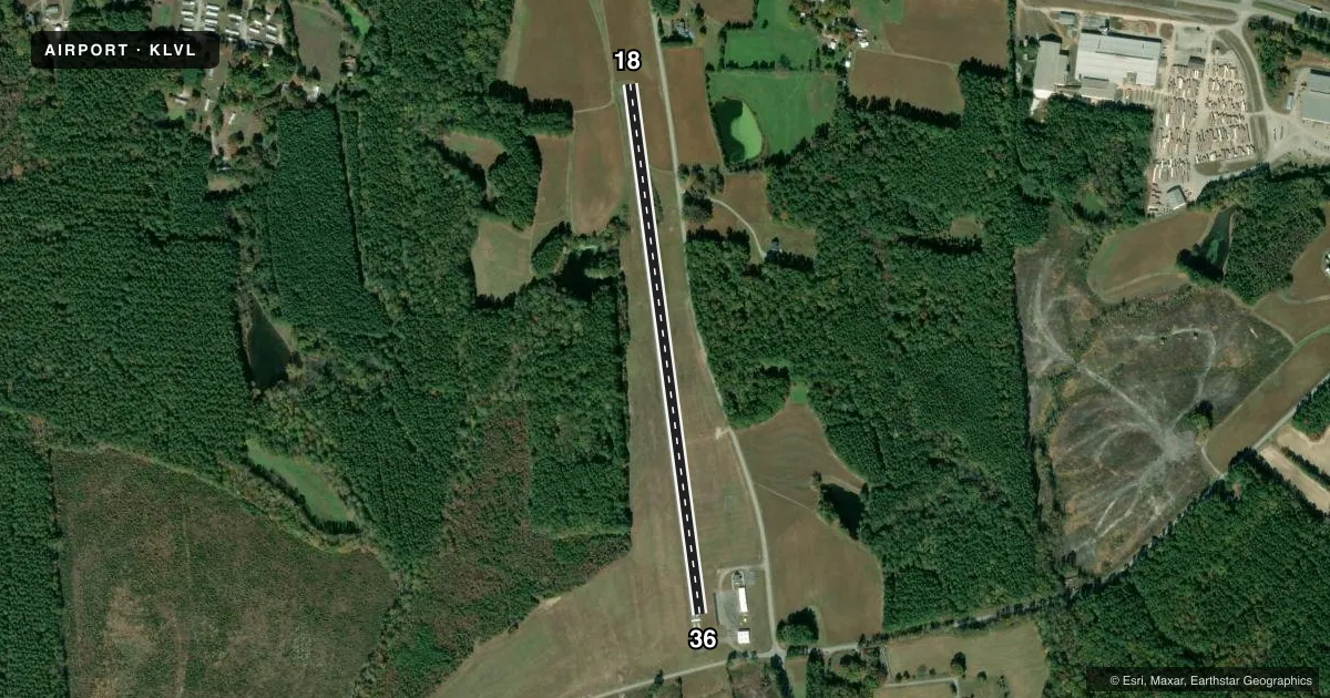
Runways & pattern
Full pagePattern entry · RWY 36
LEFT TRAFFICRunway end performance
| End | TORA | TODA | ASDA | LDA | VGSI | Approach lights | Obstruction |
|---|---|---|---|---|---|---|---|
| 18 | — | — | — | — | — | — | 48', pole, 984' from thr, 74' R of cntrln, slope 16 |
| 36 | — | — | — | — | — | — | 10', road, 254' from thr, 0' R of cntrln, slope 5 |
Declared distances in feet. TORA = takeoff run available, TODA = takeoff distance, ASDA = accelerate-stop, LDA = landing distance.
Airport sketch
Runways drawn to scale from FAA survey coordinates, rendered over satellite imagery. Not for navigation.
Approaches & charts
Services on the field
Fuel grades, oxygen, maintenance, ramp storage and lighting — as declared to the FAA by the airport operator.
Fuel & services
- Fuel
- Not available
- Oxygen (bottled)
- Not available
- Oxygen (bulk)
- Not available
- Airframe repair
- Not available
- Power plant repair
- Not available
Ramp & ground
- Transient storage
- Tie-down
- Landing fee
- No fee published
- Customs
- Not available
- Wind indicator
- Yes
- Segmented circle
- No
Fuel & FBOs
Cheapest 100LL and Jet A on the field and nearby. Always confirm with the FBO before taxi.
Airport notes
Surface conditions, obstructions, local procedures, lighting outages and other notes published with each FAA cycle.
General notes
- DEER ON & INVOF ARPT.
- ARPT CLSD SS-SR INDEFLY.
Other notes
- PRIOR TO 1959.
VFR map & nearby airports
VFR sectional. Tap any ICAO chip to open that airport.
Key facts · KLVL
Answer card- ICAO
- KLVL
- Name
- BRUNSWICK COUNTY
- Location
- LAWRENCEVILLE, VIRGINIA
- Elevation
- 328.7 ft MSL
- Traffic pattern altitude
- 1,328.7 ft MSL (1,000 AGL)
- Control tower
- Non-towered (use CTAF)
- Total runways
- 1
- Longest runway
- 18/36 · 3,020 ft
- Published ILS approaches
- 0
- Published frequencies
- 2
- Magnetic variation
- 8°
- Current flight rules
- VFR
- Current wind
- 080° at 3 kt
- Favored runway now
- RWY 36
Brunswick County Airport sits in Lawrenceville, Virginia. Field elevation is 328.7 ft MSL. The airport has one runway. Runway 18/36 is 3,020 ft long with asphalt pavement. The field is not towered. CTAF and UNICOM are both 122.8. No ILS approaches are published here.
Pattern altitude is not published. Use the standard 1,000 ft AGL for light piston operations unless the current Chart Supplement says otherwise. That puts the pattern near 1,329 ft MSL based on the field elevation. The airport is closed from sunset to sunrise indefinitely. Plan your arrival in daylight. Verify the current status before you launch.
There are no on-field FBOs listed in the facts. Contact the airport operator directly or call the field on CTAF or UNICOM for current services. Deer are reported on and near the airport. Keep a sharp scan on taxi, takeoff and landing. This is a short, single-runway field with no published ILS. Check the current Chart Supplement for any other local notes before flying in.