METAR & TAF W31
Current METAR
Observed 16:35Z
KW31 271635Z AUTO 04004KT 10SM SCT030 28/21 A2988 RMK AO1 T02800213
- Wind
- 040° @ 4 kt
- Visibility
- 10 SM
- Temp / Dew
- 28°C / 21°C
- Altimeter
- 29.88 inHg
- Clouds
- SCT
- Density alt
- 2,262 ft
- Ceiling
- Unlimited
- Rules
- VFR
Airport info & contacts
Manager on record, flight service, ARTCC, attendance schedule and pattern altitude — published by the FAA and refreshed every 28 days.
Location
- From city
- 3 NM W
- VFR sectional
- WASHINGTON
- ARTCC
- ZDC · WASHINGTON
- NOTAM facility
- DCA (NOTAM-D)
Airport manager
- Name
- LARRY WAY
- Phone
- 434-262-3750
- Address
- 634 AIRPORT ROAD, VICTORIA VA 23974
Flight service · Hours
- FSS DCA
- LEESBURG1-800-WX-BRIEF
- Attendance
- Unattended
Frequencies
Tap any row to copy the frequency to your clipboard.
Runways & pattern
Full pagePattern entry · RWY 02
LEFT TRAFFICRunway end performance
| End | TORA | TODA | ASDA | LDA | VGSI | Approach lights | Obstruction |
|---|---|---|---|---|---|---|---|
| 02 | — | — | — | — | PNIL(5°) | — | 37', tree, 318' from thr, 231' R of cntrln, slope 3 |
| 20 | — | — | — | — | PNIL(5°) | — | 53', tree, 283' from thr, 176' R of cntrln, slope 1 |
Declared distances in feet. TORA = takeoff run available, TODA = takeoff distance, ASDA = accelerate-stop, LDA = landing distance.
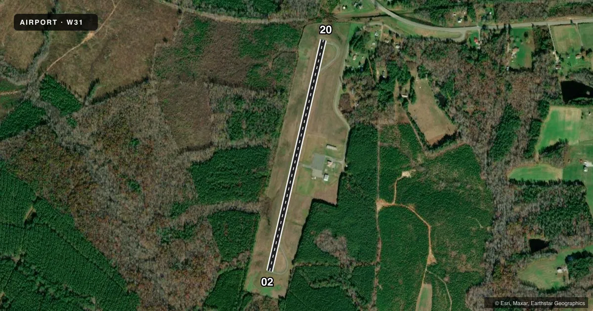
Airport sketch
Runways drawn to scale from FAA survey coordinates, rendered over satellite imagery. Not for navigation.
Approaches & charts
Services on the field
Fuel grades, oxygen, maintenance, ramp storage and lighting — as declared to the FAA by the airport operator.
Fuel & services
- Fuel
- 100LL
- Oxygen (bottled)
- Not available
- Oxygen (bulk)
- Not available
- Airframe repair
- Not available
- Power plant repair
- Not available
Ramp & ground
- Transient storage
- Tie-down
- Landing fee
- No fee published
- Customs
- Not available
- Lighting schedule
- SS-SR
- Beacon schedule
- SS-SR
- Beacon
- White / Green (civil land)(WG)
- Wind indicator
- Lighted
- Segmented circle
- No
Fuel & FBOs
Cheapest 100LL and Jet A on the field and nearby. Always confirm with the FBO before taxi.
Airport notes
Surface conditions, obstructions, local procedures, lighting outages and other notes published with each FAA cycle.
General notes
- DEER ON AND INVOF ARPT.
- FOR CD CTC WASHINGTON ARTCC AT 703-771-3587.
Fuel notes
- 100LLFUEL AVBL DALGT HRS, CTC AMGR.
Approach & departure obstructions
- 20TREE AT 195 FT FM RWY END, 216 FT RIGHT ON APCH.
VFR map & nearby airports
VFR sectional. Tap any ICAO chip to open that airport.
Key facts · W31
Answer card- ICAO
- W31
- Name
- LUNENBURG COUNTY
- Location
- KENBRIDGE, VIRGINIA
- Elevation
- 526 ft MSL
- Traffic pattern altitude
- 1,526 ft MSL (1,000 AGL)
- Control tower
- Non-towered (use CTAF)
- Total runways
- 1
- Longest runway
- 02/20 · 3,000 ft
- Published ILS approaches
- 0
- Published frequencies
- 2
- Magnetic variation
- 10°
- Current flight rules
- VFR
- Current wind
- 040° at 4 kt
- Favored runway now
- RWY 02
Lunenburg County Airport sits in Kenbridge, Virginia. Field elevation is 526 ft MSL. The airport has one runway. Runway 02/20 is 3,000 ft of asphalt, which is the longest runway on the field. There is no control tower. CTAF and UNICOM are both 122.7.
No ILS approaches are published here. Pattern altitude is not published, so use the standard 1,000 ft AGL for light piston operations unless the current Chart Supplement says otherwise. The on-field FBO is Lunenburg County Airport. It carries AVGAS 100LL. Fuel is available during daylight hours. Contact the airport manager for current availability.
A few field notes matter here. Deer are reported on and near the airport, so keep a sharp scan on taxi, takeoff and landing. There is also a tree near the approach end of runway 20, offset to the right. That makes the 20 approach worth a careful look on a short final. For IFR clearance delivery, pilots are told to contact Washington ARTCC. This is a small non-towered field. Plan your traffic calls early and keep an eye out for local traffic.