METAR & TAF KFVX
Current METAR
Observed 15:15Z
KFVX 271515Z AUTO 02005KT 10SM CLR 29/23 A2988 RMK AO2 T02870232
- Wind
- 020° @ 5 kt
- Visibility
- 10 SM
- Temp / Dew
- 29°C / 23°C
- Altimeter
- 29.88 inHg
- Clouds
- CLR
- Density alt
- 2,245 ft
- Ceiling
- Unlimited
- Rules
- VFR
Airport info & contacts
Manager on record, flight service, ARTCC, attendance schedule and pattern altitude — published by the FAA and refreshed every 28 days.
Location
- From city
- 4 NM NW
- VFR sectional
- WASHINGTON
- ARTCC
- ZDC · WASHINGTON
- NOTAM facility
- FVX (NOTAM-D)
Airport manager
- Name
- SCOTT DAVIS
- Phone
- 434-392-5686
- Address
- P.O. DRAWER 368, FARMVILLE VA 23901-9116
Flight service · Hours
- FSS DCA
- LEESBURG1-800-WX-BRIEF
- Attendance
- 0730-1700
Frequencies
Tap any row to copy the frequency to your clipboard.
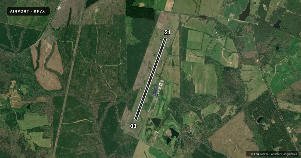
Runways & pattern
Full pagePattern entry · RWY 03
LEFT TRAFFICRunway end performance
| End | TORA | TODA | ASDA | LDA | VGSI | Approach lights | Obstruction |
|---|---|---|---|---|---|---|---|
| 03 | — | — | — | — | PAPI 2-box left(3°) | — | 41', tree, 824' from thr, 132' R of cntrln, slope 15 |
| 21 | — | — | — | — | PAPI 2-box left(3°) | — | 48', tree, 1180' from thr, 388' R of cntrln, slope 20 |
Declared distances in feet. TORA = takeoff run available, TODA = takeoff distance, ASDA = accelerate-stop, LDA = landing distance.
Airport sketch
Runways drawn to scale from FAA survey coordinates, rendered over satellite imagery. Not for navigation.
Approaches & charts
Services on the field
Fuel grades, oxygen, maintenance, ramp storage and lighting — as declared to the FAA by the airport operator.
Fuel & services
- Fuel
- 100LLA
- Oxygen (bottled)
- Not available
- Oxygen (bulk)
- Not available
- Airframe repair
- Minor
- Power plant repair
- Minor
- Other services
- CHTR,INSTR,RNTL,SURV
Ramp & ground
- Transient storage
- Tie-down
- Hangar
- Landing fee
- No fee published
- Customs
- Not available
- Lighting schedule
- SEE RMK
- Beacon schedule
- SS-SR
- Beacon
- White / Green (civil land)(WG)
- Wind indicator
- Lighted
Fuel & FBOs
Cheapest 100LL and Jet A on the field and nearby. Always confirm with the FBO before taxi.
Airport notes
Surface conditions, obstructions, local procedures, lighting outages and other notes published with each FAA cycle.
General notes
- DEER ON AND INVOF ARPT.
- LGTD TWR 320 AGL 5.8 MI SW.
- POSS UNMANNED AERIAL VEHICLE OPER 5 NM FROM FARMVILLE ARPT 3000 FT AGL & BLW.
- ROA TWR SVCS AVBL AT 540-563-1307.
- FOR CD CTC ROANOKE APCH AT 540-563-1307.
Lighting notes
- REIL RWY 3 & 21; MIRL RWY 03/21; PRESET LOW INTST, TO INCR INTST ACTVT - CTAF.
Approach & departure obstructions
- 03TERRAIN 333 FT FROM THR, 128 RIGHT OF CTLN AND 10 FT ABOVE RWY ELEVATION.
VFR map & nearby airports
VFR sectional. Tap any ICAO chip to open that airport.
Key facts · KFVX
Answer card- ICAO
- KFVX
- Name
- FARMVILLE RGNL
- Location
- FARMVILLE, VIRGINIA
- Elevation
- 415.7 ft MSL
- Traffic pattern altitude
- 1,415.7 ft MSL (1,000 AGL)
- Control tower
- Non-towered (use CTAF)
- Total runways
- 1
- Longest runway
- 03/21 · 4,400 ft
- Published ILS approaches
- 0
- Published frequencies
- 4
- Magnetic variation
- 9°
- Current flight rules
- VFR
- Current wind
- 020° at 5 kt
- Favored runway now
- RWY 03
Farmville Regional Airport sits in Farmville, Virginia. Field elevation is 415.7 ft MSL. The airport has one runway. Runway 03/21 is 4,400 ft of asphalt. There is no control tower. Traffic uses CTAF 122.8. The published pattern altitude is not listed, so use the standard 1,000 ft AGL for light piston aircraft unless current local guidance says otherwise.
No ILS approaches are published here. For IFR work, plan with the current charted procedures and coordinate with Roanoke Approach as needed. The field has one on-field FBO, Farmville Regional Airport. It carries 100LL and Jet A. Call (434) 391-6111 for current service details before you launch.
A few published remarks matter on arrival. Runway end identifier lights are installed on 03 and 21. The runway lights are medium intensity and start at low intensity. Use the CTAF to step them up. Deer are reported on and near the airport. There is also a terrain note near the threshold of Runway 03. A lighted tower sits 5.8 miles southwest. Pilots should also watch for possible UAV activity within 5 NM of the airport at 3,000 ft AGL and below. This is a non-towered field with nearby Roanoke frequency support, so brief your arrival well and keep an eye out on final.