METAR & TAF W24
W24 does not publish a METAR.
Showing the nearest reporting station: KLYH (LYNCHBURG RGNL/PRESTON GLENN FLD) · 4.9 NM away. Conditions at W24 may differ.
METAR · KLYH
Observed 11:54Z
KLYH 271154Z 02004KT 10SM BKN070 21/20 A2992 RMK AO2 SLP121 T02110200 10211 20178 51017
- Wind
- 020° @ 4 kt
- Visibility
- 10 SM
- Temp / Dew
- 21°C / 20°C
- Altimeter
- 29.92 inHg
- Clouds
- BKN
- Density alt
- 1,884 ft
- Ceiling
- 7,000 ft AGL
- Rules
- VFR
Airport info & contacts
Manager on record, flight service, ARTCC, attendance schedule and pattern altitude — published by the FAA and refreshed every 28 days.
Location
- From city
- 3 NM SE
- VFR sectional
- CINCINNATI
- Pattern altitude
- 800 ft AGL · 1,739 ft MSL
- ARTCC
- ZDC · WASHINGTON
- NOTAM facility
- DCA (NOTAM-D)
Airport manager
- Name
- ROGER BECK
- Phone
- 434-845-8769
- Address
- MCLAREN CORP., 4332 RICHMOND HWY, LYNCHBURG VA 24501
Flight service · Hours
- FSS DCA
- LEESBURG1-800-WX-BRIEF
- Attendance
- APR-OCT · 0700-1900
- 0700-1800
Frequencies
Tap any row to copy the frequency to your clipboard.
Runways & pattern
Full pagePattern entry · RWY 10
LEFT TRAFFICRunway end performance
| End | TORA | TODA | ASDA | LDA | VGSI | Approach lights | Obstruction |
|---|---|---|---|---|---|---|---|
| 10 | — | — | — | — | — | — | 59', tree, 315' from thr, 89' R of cntrln, slope 1 |
| 28 | — | — | — | — | TRIL | — | 20', trees, 310' from thr, 171' R of cntrln, slope 5 |
Declared distances in feet. TORA = takeoff run available, TODA = takeoff distance, ASDA = accelerate-stop, LDA = landing distance.
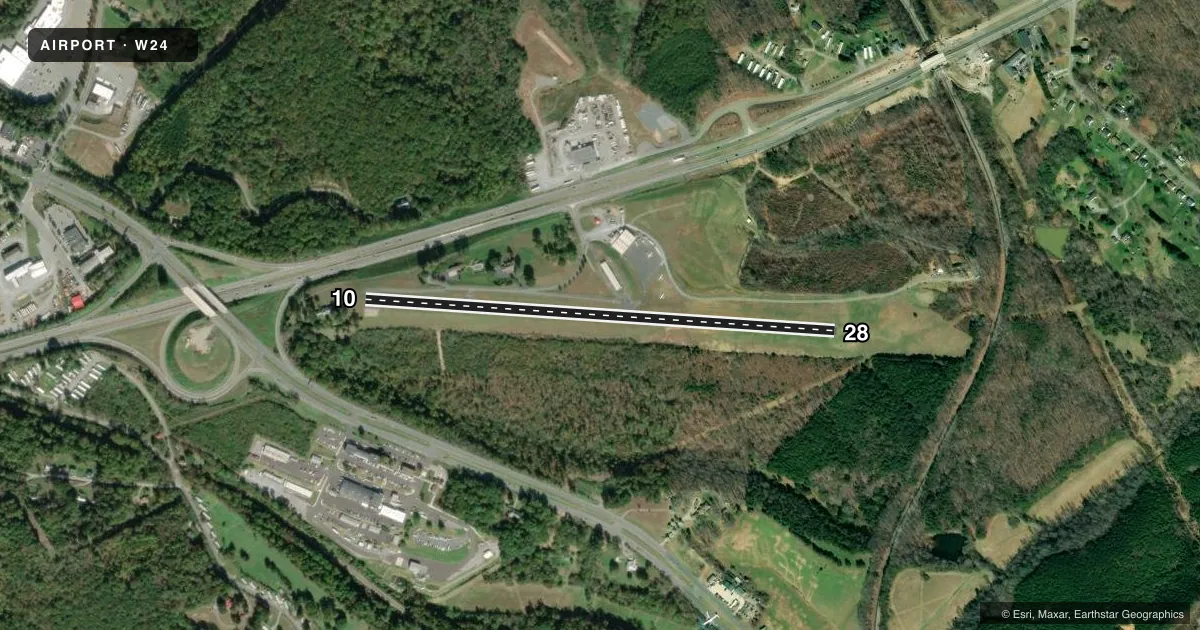
Airport sketch
Runways drawn to scale from FAA survey coordinates, rendered over satellite imagery. Not for navigation.
Approaches & charts
Services on the field
Fuel grades, oxygen, maintenance, ramp storage and lighting — as declared to the FAA by the airport operator.
Fuel & services
- Fuel
- 100LL
- Oxygen (bottled)
- Not available
- Oxygen (bulk)
- Not available
- Airframe repair
- Major
- Power plant repair
- Major
- Other services
- CHTR,INSTR,RNTL,SURV
Ramp & ground
- Transient storage
- Tie-down
- Hangar
- Landing fee
- No fee published
- Lighting schedule
- SEE RMK
- Wind indicator
- Lighted
- Segmented circle
- No
Fuel & FBOs
Cheapest 100LL and Jet A on the field and nearby. Always confirm with the FBO before taxi.
Airport notes
Surface conditions, obstructions, local procedures, lighting outages and other notes published with each FAA cycle.
General notes
- NO TGL.
- DEER ON AND INVOF ARPT.
- ROA TWR SVCS AVBL AT 540-563-1307.
- FOR CD CTC ROANOKE APCH AT 540-563-1307.
- RUNWAY 28 CLOSED FOR TAKE-OFF RUNWAY 10 CLOSED FOR LANDING
Lighting notes
- ACTIVATE TRIL RWY 28 CTAF
Runway surface & condition
- 10/28LAND RY 28 (WEST) TKOF RY 10 (EAST).
Approach & departure obstructions
- 10RWY 10 +47 FT TREE 89 FT FROM THLD 76 FT RHT.
- 2813 FT LINE OF TREES 180 FT LEFT OF THR ON APCH.
Other notes
- PRIOR TO 1959
VFR map & nearby airports
VFR sectional. Tap any ICAO chip to open that airport.
Key facts · W24
Answer card- ICAO
- W24
- Name
- FALWELL
- Location
- LYNCHBURG, VIRGINIA
- Elevation
- 939 ft MSL
- Traffic pattern altitude
- 1,739 ft MSL (800 AGL)
- Control tower
- Non-towered (use CTAF)
- Total runways
- 1
- Longest runway
- 10/28 · 2,932 ft
- Published ILS approaches
- 0
- Published frequencies
- 5
- Magnetic variation
- 9°
- Current flight rules
- VFR
- Current wind
- 020° at 4 kt
- Favored runway now
- RWY 10
FALWELL is in Lynchburg, Virginia. The field elevation is 939 ft MSL. It has one runway. Runway 10/28 is 2,932 ft long. There is no control tower. Roanoke Approach handles clearance delivery and tower services by phone when needed. Pattern altitude is 800 ft AGL, which is 1,739 ft MSL.
No ILS approaches are published here. The on-field FBO is McLaren Corporation. It carries 100LL. Deer are reported on and near the airport, so keep a sharp scan on taxi, takeoff and landing. Published remarks also say runway 28 is used for landing and runway 10 is used for takeoff. Runway 28 is closed for takeoff. Runway 10 is closed for landing. There is a 13-foot line of trees left of the runway 28 threshold on approach. Runway 10 also has a 47-foot tree near the threshold on the right side. Runway 28 lighting is activated on CTAF. First-time visitors should plan for a small non-towered field with published local restrictions. Check the current FAA Chart Supplement before you go. Confirm any operational details with the airport operator or McLaren Corporation by phone.