METAR & TAF W13
Current METAR
Observed 15:15Z
KW13 271515Z AUTO 33005KT 10SM CLR 25/18 A2995 RMK AO1 T02450179
- Wind
- 330° @ 5 kt
- Visibility
- 10 SM
- Temp / Dew
- 25°C / 18°C
- Altimeter
- 29.95 inHg
- Clouds
- CLR
- Density alt
- 2,943 ft
- Ceiling
- Unlimited
- Rules
- VFR
Airport info & contacts
Manager on record, flight service, ARTCC, attendance schedule and pattern altitude — published by the FAA and refreshed every 28 days.
Location
- From city
- 3 NM W
- VFR sectional
- WASHINGTON
- ARTCC
- ZDC · WASHINGTON
- NOTAM facility
- DCA (NOTAM-D)
Airport manager
- Name
- MICHAEL T.K. ROSOLINA
- Phone
- 540-943-4447
- Address
- 249 AERO DR, WAYNESBORO VA 22980
Flight service · Hours
- FSS DCA
- LEESBURG1-800-WX-BRIEF
- Attendance
- MON - FRI · 0800 - 1700
- SUN · 1000 - 1600
- SAT · 0900 - 1600
Frequencies
Tap any row to copy the frequency to your clipboard.
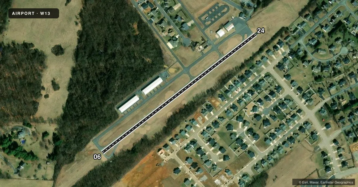
Runways & pattern
Full pagePattern entry · RWY 06
LEFT TRAFFICRunway end performance
| End | TORA | TODA | ASDA | LDA | VGSI | Approach lights | Obstruction |
|---|---|---|---|---|---|---|---|
| 06 | — | — | — | — | — | — | 48', tree, 490' from thr, 117' R of cntrln, slope 6 |
| 24 | — | — | — | — | — | — | 28', tree, 535' from thr, 136' R of cntrln, slope 11 |
Declared distances in feet. TORA = takeoff run available, TODA = takeoff distance, ASDA = accelerate-stop, LDA = landing distance.
Airport sketch
Runways drawn to scale from FAA survey coordinates, rendered over satellite imagery. Not for navigation.
Approaches & charts
Services on the field
Fuel grades, oxygen, maintenance, ramp storage and lighting — as declared to the FAA by the airport operator.
Fuel & services
- Fuel
- 100LL
- Oxygen (bottled)
- Not available
- Oxygen (bulk)
- Not available
- Airframe repair
- Major
- Power plant repair
- Major
- Other services
- GLD,INSTR,RNTL
Ramp & ground
- Transient storage
- Tie-down
- Hangar
- Landing fee
- No fee published
- Customs
- Not available
- Lighting schedule
- SEE RMK
- Beacon schedule
- SS-SR
- Beacon
- White / Green (civil land)(WG)
- Wind indicator
- Yes
- Segmented circle
- No
Fuel & FBOs
Cheapest 100LL and Jet A on the field and nearby. Always confirm with the FBO before taxi.
Airport notes
Surface conditions, obstructions, local procedures, lighting outages and other notes published with each FAA cycle.
General notes
- DEER ON AND INVOF ARPT.
- NO REPETITIVE PRACTICE TKOFS AND LDGS AFT 0100Z.
- NO GRASS LANDINGS OR TAKEOFFS EITHER SIDE OF RWY 06/24.
- FOR CD CTC POTOMAC APCH AT 866-640-4124.
Lighting notes
- ACTVT MIRL RWY 06/24 - CTAF.
Approach & departure obstructions
- 068 FT BRUSH AND TREES LEFT SIDE OF RWY APRXLY 155 FM THR AND 108 FT FM CNTRLN.
Other notes
- IN OPERATION PRIOR 1959.
VFR map & nearby airports
VFR sectional. Tap any ICAO chip to open that airport.
Key facts · W13
Answer card- ICAO
- W13
- Name
- EAGLE'S NEST
- Location
- WAYNESBORO, VIRGINIA
- Elevation
- 1,436 ft MSL
- Traffic pattern altitude
- 2,436 ft MSL (1,000 AGL)
- Control tower
- Non-towered (use CTAF)
- Total runways
- 1
- Longest runway
- 06/24 · 2,004 ft
- Published ILS approaches
- 0
- Published frequencies
- 4
- Magnetic variation
- 9°
- Current flight rules
- VFR
- Current wind
- 330° at 5 kt
- Favored runway now
- RWY 06
Eagle's Nest is in Waynesboro, Virginia. Field elevation is 1,436 ft MSL. The airport has one runway, 06/24, which is 2,004 ft long and asphalt. There is no control tower. Pattern altitude is not published. Use standard 1,000 ft AGL for light piston unless the current Chart Supplement says otherwise. No ILS approaches are published here.
The field sits in a part of Virginia where terrain and density altitude can matter on warm days. The runway is short. Plan your performance numbers with that in mind. Deer are reported on and near the airport. There is also an obstruction note for runway 06. Brush and trees are left of the runway near the threshold area, so give yourself a careful look on arrival and departure.
Eagle's Nest Flight Services is on the field. It carries 100LL. CTAF and UNICOM are both 123.05. Medium intensity runway lights on 06/24 are activated by CTAF. For clearance delivery, Potomac Approach is the contact listed in the remarks. No repetitive practice takeoffs and landings are allowed after 0100 Zulu. The airport has been in operation since before 1959.