METAR & TAF KSHD
Current METAR
Observed 15:15Z
KSHD 271515Z AUTO 04003KT 10SM CLR 25/18 A2995 RMK AO2 T02480183
- Wind
- 040° @ 3 kt
- Visibility
- 10 SM
- Temp / Dew
- 25°C / 18°C
- Altimeter
- 29.95 inHg
- Clouds
- CLR
- Density alt
- 2,652 ft
- Ceiling
- Unlimited
- Rules
- VFR
Airport info & contacts
Manager on record, flight service, ARTCC, attendance schedule and pattern altitude — published by the FAA and refreshed every 28 days.
Location
- From city
- 10 NM NE
- VFR sectional
- WASHINGTON
- ARTCC
- ZDC · WASHINGTON
- NOTAM facility
- SHD (NOTAM-D)
Airport manager
- Name
- LISA BOTKIN
- Phone
- 540-234-8304
- Address
- 77 AVIATION CIR., WEYERS CAVE VA 24486
Flight service · Hours
- FSS DCA
- LEESBURG1-800-WX-BRIEF
- Attendance
- ALL
Frequencies
Tap any row to copy the frequency to your clipboard.
Runways & pattern
Full pagePattern entry · RWY 05
LEFT TRAFFICRunway end performance
| End | TORA | TODA | ASDA | LDA | VGSI | Approach lights | Obstruction |
|---|---|---|---|---|---|---|---|
| 05 | 6,002' | 6,002' | 6,002' | 6,002' | PAPI 4-box left(3°) | MALSR | 59', pole, 2500' from thr, 300' R of cntrln, slope 38 |
| 23 | 6,002' | 6,002' | 6,002' | 6,002' | PAPI 4-box left(3°) | — | — |
Declared distances in feet. TORA = takeoff run available, TODA = takeoff distance, ASDA = accelerate-stop, LDA = landing distance.
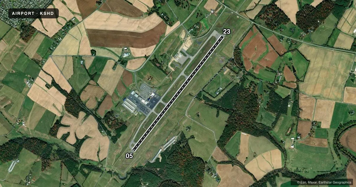
Airport sketch
Runways drawn to scale from FAA survey coordinates, rendered over satellite imagery. Not for navigation.
Approaches & charts
ILS · 1
Services on the field
Fuel grades, oxygen, maintenance, ramp storage and lighting — as declared to the FAA by the airport operator.
Fuel & services
- Fuel
- 100LLA
- Oxygen (bottled)
- HIGH/LOW
- Oxygen (bulk)
- Not available
- Airframe repair
- Major
- Power plant repair
- Major
- Other services
- AGRI,CARGO,INSTR,RNTL
Ramp & ground
- Transient storage
- Tie-down
- Hangar
- Landing fee
- No fee published
- Customs
- Not available
- Lighting schedule
- SEE RMK
- Beacon schedule
- SS-SR
- Beacon
- White / Green (civil land)(WG)
- Wind indicator
- Lighted
- Segmented circle
- No
Fuel & FBOs
Cheapest 100LL and Jet A on the field and nearby. Always confirm with the FBO before taxi.
Airport notes
Surface conditions, obstructions, local procedures, lighting outages and other notes published with each FAA cycle.
General notes
- FOR CD CTC POTOMAC APCH AT 866-640-4124.
Lighting notes
- ACTVT MALSR RWY 05; REIL RWY 23; HIRL RWY 05/23 & TWY LGTS - CTAF. PAPI RWY 05 & 23 OPRS CONSLY.
Runway surface & condition
- 05/23PCR VALUE: 554/F/B/X/T
Other notes
- PPR 12 HRS FOR UNSKED ACR OPNS WITH MORE THAN 30 PSGR SEATS CALL 540-234-8304.
- TPA 800 FT PISTON ACFT, 1500 FT JET/TURBO ACFT.
VFR map & nearby airports
VFR sectional. Tap any ICAO chip to open that airport.
Key facts · KSHD
Answer card- ICAO
- KSHD
- Name
- SHENANDOAH VALLEY RGNL
- Location
- STAUNTON/WAYNESBORO/HARRISONBURG, VIRGINIA
- Elevation
- 1,201 ft MSL
- Traffic pattern altitude
- 2,201 ft MSL (1,000 AGL)
- Control tower
- Non-towered (use CTAF)
- Total runways
- 1
- Longest runway
- 05/23 · 6,002 ft
- Published ILS approaches
- 1
- Published frequencies
- 5
- Magnetic variation
- 9°
- Current flight rules
- VFR
- Current wind
- 040° at 3 kt
- Favored runway now
- RWY 05
Shenandoah Valley Rgnl Airport sits near Staunton, Waynesboro and Harrisonburg in Virginia. Field elevation is 1,201 ft MSL. The airport has one runway, 05/23, which is 6,002 ft long. There is no control tower. Use CTAF 123.0 or UNICOM 123.0 for local traffic calls.
One ILS approach is published for runway 05. Runway 05 also has MALSR lighting. Runway 23 has runway end identifier lights. High intensity runway lights are on both ends. Taxiway lighting is available. PAPI is available on both runway ends and operates continuously. The published pattern altitude is 800 ft AGL for piston aircraft. Jet and turbo aircraft use 1,500 ft AGL.
Shenandoah Valley Regional Airport is the on-field FBO. It carries 100LL, Jet A and Jet A Prist. Call (540) 234-8304 for current service details. For clearance delivery, Potomac Approach can be reached at 866-640-4124. The airport sits in the Shenandoah Valley, so plan for valley terrain and check winds before arrival. For any current noise, curfew, or special operating limits, verify the current FAA Chart Supplement or call the airport operator before you go.