METAR & TAF W99
Current METAR
Observed 15:55Z
KW99 271555Z AUTO VRB03KT 10SM FEW045 26/22 A2990 RMK AO2 T02610225 $
- Wind
- VAR @ 3 kt
- Visibility
- 10 SM
- Temp / Dew
- 26°C / 22°C
- Altimeter
- 29.90 inHg
- Clouds
- FEW
- Density alt
- 2,539 ft
- Ceiling
- Unlimited
- Rules
- VFR
Airport info & contacts
Manager on record, flight service, ARTCC, attendance schedule and pattern altitude — published by the FAA and refreshed every 28 days.
Location
- From city
- 1 NM SW
- VFR sectional
- CINCINNATI
- ARTCC
- ZDC · WASHINGTON
- NOTAM facility
- EKN (NOTAM-D)
Airport manager
- Name
- TOM FEASTER
- Phone
- 304-257-4435
- Address
- 440 AIRPORT RD, PETERSBURG WV 26802
Flight service · Hours
- FSS EKN
- ELKINS703-724-42881-800-WX-BRIEF
- Attendance
- 0700-1900
Frequencies
Tap any row to copy the frequency to your clipboard.
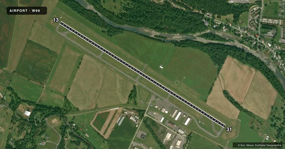
Runways & pattern
Full pagePattern entry · RWY 31
RIGHT TRAFFICRunway end performance
| End | TORA | TODA | ASDA | LDA | VGSI | Approach lights | Obstruction |
|---|---|---|---|---|---|---|---|
| 13 | — | — | — | — | — | — | 6', fence, 201' from thr, 250' R of cntrln, slope 0 |
| 31 | — | — | — | — | PAPI 4-box left(6.5°) | — | 6', fence, 305' from thr, 255' R of cntrln, slope 17 |
Declared distances in feet. TORA = takeoff run available, TODA = takeoff distance, ASDA = accelerate-stop, LDA = landing distance.
Airport sketch
Runways drawn to scale from FAA survey coordinates, rendered over satellite imagery. Not for navigation.
Approaches & charts
ILS · 1
Services on the field
Fuel grades, oxygen, maintenance, ramp storage and lighting — as declared to the FAA by the airport operator.
Fuel & services
- Fuel
- 100LLA
- Oxygen (bulk)
- Not available
- Airframe repair
- Major
- Power plant repair
- Major
Ramp & ground
- Transient storage
- Tie-down
- Hangar
- Landing fee
- No fee published
- Customs
- Not available
- Lighting schedule
- SEE RMK
- Beacon schedule
- SS-SR
- Beacon
- White / Green (civil land)(WG)
- Wind indicator
- Lighted
- Segmented circle
- Yes
Fuel & FBOs
Cheapest 100LL and Jet A on the field and nearby. Always confirm with the FBO before taxi.
Airport notes
Surface conditions, obstructions, local procedures, lighting outages and other notes published with each FAA cycle.
General notes
- BIRDS ON & INVOF ARPT.
- FLY-IN CAMPGROUND ON ARPT.
- COLD TEMPERATURE AIRPORT. ALTITUDE CORRECTION REQUIRED AT OR BELOW -7C.
- FOR CD CTC WASHINGTON ARTCC AT 703-771-3587.
Lighting notes
- ACTVT REIL RWY 13 & 31; PAPI RWY 31; MIRL RWY 13/31 - CTAF.
Fuel notes
- 100LLSELF SVC FUEL 24/7.
Approach & departure obstructions
- 31RIGHT TRAFFIC FOR GLIDER AND ULTRA-LIGHT ONLY. ALL OTHER POWERED AIRCRAFT STANDARD LEFT TRAFFIC PATTERN.
Other notes
- EXISTED PRIOR TO 1959.
- GLIDER OPS.
- OVNGT TIEDOWN FEE WAIVED WITH FUEL PURCHASE.
- 1AFTR HRS ON CALL 304-209-2603.
VFR map & nearby airports
VFR sectional. Tap any ICAO chip to open that airport.
Key facts · W99
Answer card- ICAO
- W99
- Name
- GRANT COUNTY
- Location
- PETERSBURG, WEST VIRGINIA
- Elevation
- 962.9 ft MSL
- Traffic pattern altitude
- 1,962.9 ft MSL (1,000 AGL)
- Control tower
- Non-towered (use CTAF)
- Total runways
- 1
- Longest runway
- 13/31 · 5,000 ft
- Published ILS approaches
- 1
- Published frequencies
- 2
- Magnetic variation
- 8°
- Current flight rules
- VFR
- Current wind
- 000° at 3 kt
- Favored runway now
- RWY 31
Grant County Airport (W99) sits near Petersburg, West Virginia. Field elevation is 962.9 ft MSL. The airport has one runway. Runway 13/31 is 5,000 ft long with asphalt pavement. The field is not towered. CTAF and UNICOM are both 122.8. The published ILS serves runway 31. Pattern altitude is not published. Use the standard 1,000 ft AGL pattern unless ATC or local procedure says otherwise.
Touch & Go Aviation is on the field. It carries 100LL and Jet A. Self-serve 100LL is available 24 hours a day, 7 days a week. Published remarks also note after-hours service on call at 304-209-2603. The airport has medium intensity runway lights on 13 and 31. Runway end identifier lights are installed. PAPI is installed for runway 31. Lighting is controlled on the common traffic advisory frequency.
A few local items matter here. Glider operations are conducted at the airport. Right traffic is for glider and ultra-light aircraft only. All other powered aircraft use left traffic. Birds are present on and near the field. The airport is a cold temperature airport. Altitude correction is required at or below minus 7 degrees Celsius. For clearance delivery, contact Washington ARTCC at 703-771-3587.