METAR & TAF KEKN
Current METAR
Observed 12:29Z
KEKN 271229Z AUTO 00000KT 10SM SCT015 BKN030 20/19 A2999 RMK AO2 T02000189
- Wind
- 000° @ 0 kt
- Visibility
- 10 SM
- Temp / Dew
- 20°C / 19°C
- Altimeter
- 29.99 inHg
- Clouds
- BKN
- Density alt
- 2,977 ft
- Ceiling
- 3,000 ft AGL
- Rules
- MVFR
Airport info & contacts
Manager on record, flight service, ARTCC, attendance schedule and pattern altitude — published by the FAA and refreshed every 28 days.
Location
- From city
- 2 NM S
- VFR sectional
- CINCINNATI
- Pattern altitude
- 1,013 ft AGL · 3,000 ft MSL
- ARTCC
- ZOB · CLEVELAND
- NOTAM facility
- EKN (NOTAM-D)
Airport manager
- Name
- MARY ALICE RICOTTILLI
- Phone
- 304-636-2726
- Address
- 400 AIRPORT RD, ELKINS WV 26241
Flight service · Hours
- FSS EKN
- ELKINS703-724-42881-800-WX-BRIEF
- Attendance
- 0830-1700
Frequencies
Tap any row to copy the frequency to your clipboard.
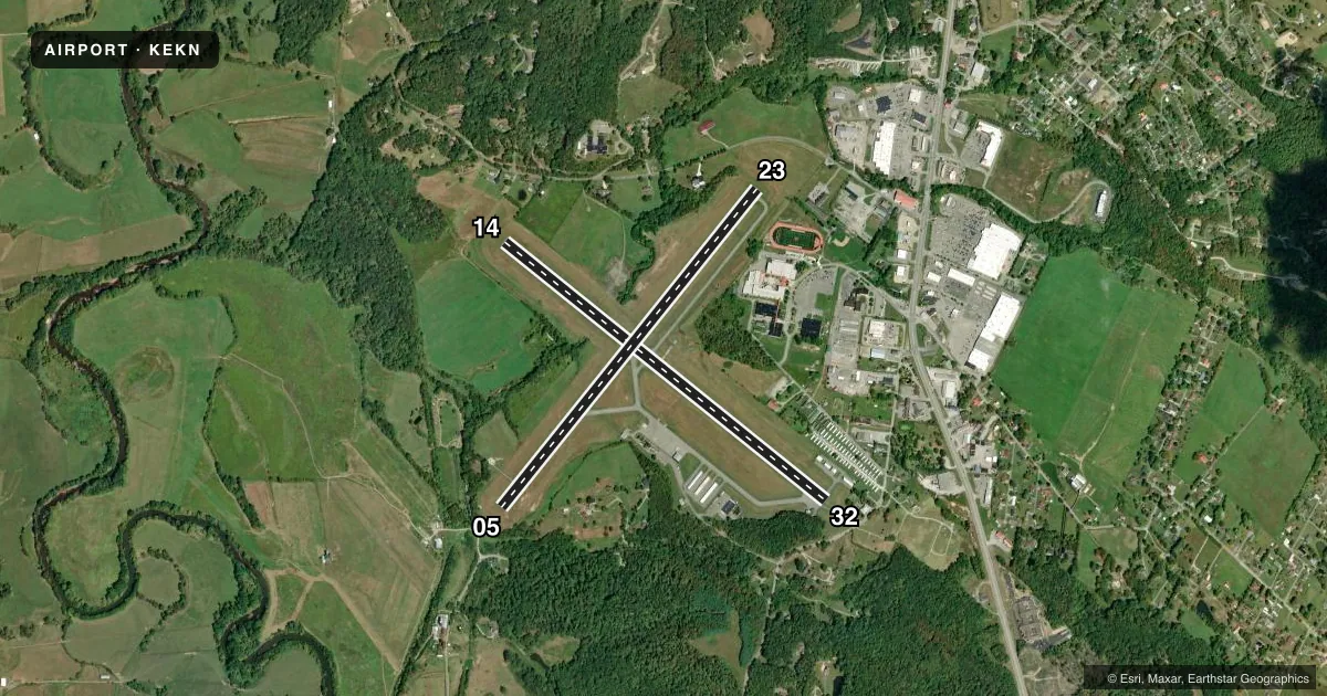
Runways & pattern
Full pagePattern entry · RWY 14
LEFT TRAFFIC| Runway | Heading (°M) | Length | Surface | Traffic |
|---|---|---|---|---|
| 14/32 | 122° / 302° | 4,544 ft | ASPH | Standard L |
| 05/23 | 32° / 212° | 4,501 ft | ASPH | Standard L |
Runway end performance
| End | TORA | TODA | ASDA | LDA | VGSI | Approach lights | Obstruction |
|---|---|---|---|---|---|---|---|
| 14 | — | — | — | — | — | — | 68', tree, 600' from thr, 285' R of cntrln, slope 5 |
| 32 | — | — | — | — | — | — | 90', trees, 201' from thr, 235' R of cntrln, slope 0 |
| 05 | — | — | — | — | — | — | 45', trees, 201' from thr, 176' R of cntrln, slope 0 |
| 23 | — | — | — | — | PAPI 2-box left(5°) | — | 258', ant, 2135' from thr, 480' R of cntrln, slope 7 |
Declared distances in feet. TORA = takeoff run available, TODA = takeoff distance, ASDA = accelerate-stop, LDA = landing distance.
Airport sketch
Runways drawn to scale from FAA survey coordinates, rendered over satellite imagery. Not for navigation.
Approaches & charts
ILS · 1
Services on the field
Fuel grades, oxygen, maintenance, ramp storage and lighting — as declared to the FAA by the airport operator.
Fuel & services
- Fuel
- 100LLA
- Oxygen (bottled)
- Not available
- Oxygen (bulk)
- Not available
- Other services
- INSTR
Ramp & ground
- Transient storage
- Tie-down
- Hangar
- Landing fee
- No fee published
- Customs
- Not available
- Lighting schedule
- SEE RMK
- Beacon schedule
- SS-SR
- Beacon
- White / Green (civil land)(WG)
- Wind indicator
- Lighted
- Segmented circle
- No
Fuel & FBOs
Cheapest 100LL and Jet A on the field and nearby. Always confirm with the FBO before taxi.
Airport notes
Surface conditions, obstructions, local procedures, lighting outages and other notes published with each FAA cycle.
General notes
- UNCONTROLLED VEHICLES CROSSING RWY 32 THR.
- DEER ON & INVOF ARPT.
- RWY 05/23 & 14/32 2-12 INCH DEEP DRAINAGE STRUCTURES ON PAVED SHOULDERS.
- FOR AFTR HRS SERV. CALL AMGR DURING BUS. HRS.
- COLD TEMPERATURE AIRPORT. ALTITUDE CORRECTION REQUIRED AT OR BELOW -19C.
- RWY 23, 68 FT ATHLETIC FIELD LGTS, 550 FT S OF RWY CL.
- FOR CD IF UNA TO CTC ON FSS FREQ, CTC WASHINGTON ARTCC AT 703-771-3587.
Lighting notes
- ACTVT MIRL RWY 05/23 & REIL RWY 23 - 122.9.
Fuel notes
- AALL FUELING 24HR SELF SERVICE.
Runway surface & condition
- 00XTHIS RUNWAY EXISTS TO SUPPORT THE OUW LDA/DME ASSOCIATED WITH THIS AIRPORT.
Approach & departure obstructions
- 0530 FT TREES, 64-199 FT DSTC, 248 FT R.
- 32156 FT TREES, 110 FT DSTC, 220 FT L. 30 FT HGR, 0 FT DSTC, 149 FT L.
- 23OMNI-DIRECTIONAL REIL.
- 14RWY MKGS FADED.
- 32RWY MKGS FADED.
- 23PAPI NON-STD 5 DEG GA.
- 0586 FT ANTENNA, 850 FM RWY END 180 FT R, APCH SLOPE 11:1 TO DSPLCD THR.
- 32APCH SLOPE 8:1 AT DSPLCD THR OVR 156 FT TREE, 1400 FT DSTC, 300 FT L.
Other notes
- PRVDD DALGT VFR ONLY.
VFR map & nearby airports
VFR sectional. Tap any ICAO chip to open that airport.
Key facts · KEKN
Answer card- ICAO
- KEKN
- Name
- ELKINS/RANDOLPH COUNTY (JENNINGS RANDOLPH FLD)
- Location
- ELKINS, WEST VIRGINIA
- Elevation
- 1,987.2 ft MSL
- Traffic pattern altitude
- 3,000.2 ft MSL (1,013 AGL)
- Control tower
- Non-towered (use CTAF)
- Total runways
- 2
- Longest runway
- 14/32 · 4,544 ft
- Published ILS approaches
- 1
- Published frequencies
- 3
- Magnetic variation
- 7°
- Current flight rules
- MVFR
- Current wind
- 000° at 0 kt
- Favored runway now
- –
KEKN is in Elkins, West Virginia. The field elevation is 1,987.2 ft MSL. It has two asphalt runways. The longest is runway 14/32 at 4,544 ft. There is no control tower. CTAF is 123.6. Approach control is handled by Clarksburg on 121.15 or 284.65.
The airport has one ILS approach. Published pattern altitude is 1,013 ft AGL, which is 3,000.2 ft MSL. That matters here because the field sits high enough that density altitude can bite in warm weather. The published remarks also call this a cold temperature airport. Altitude correction is required at or below minus 19 degrees Celsius.
The on-field FBO is Elkins-Randolph County Regional Airport. It carries AVGAS 100LL, JET A and JET A Prist. If you need after-hours service, call the airport manager during business hours. Be ready for a few local quirks. Runway 14 and runway 32 markings are faded. Runway 23 has REILs. There are obstructions near both ends, including trees near runway 05 and a tall antenna near the runway 05 approach. Uncontrolled vehicles also cross the runway 32 threshold. Keep your scan active on the ground and on short final.