METAR & TAF 6W0
6W0 does not publish a METAR.
Showing the nearest reporting station: KCKB (NORTH CENTRAL WEST VIRGINIA) · 6.9 NM away. Conditions at 6W0 may differ.
METAR · KCKB
Observed 05:53Z
KCKB 270553Z AUTO 00000KT 10SM CLR 20/19 A2993 RMK AO2 SLP118 60000 T02000189 10239 20200 50001
- Wind
- 000° @ 0 kt
- Visibility
- 10 SM
- Temp / Dew
- 20°C / 19°C
- Altimeter
- 29.93 inHg
- Clouds
- CLR
- Density alt
- 1,824 ft
- Ceiling
- Unlimited
- Rules
- VFR
Airport info & contacts
Manager on record, flight service, ARTCC, attendance schedule and pattern altitude — published by the FAA and refreshed every 28 days.
Location
- From city
- 1 NM NE
- VFR sectional
- CINCINNATI
- ARTCC
- ZOB · CLEVELAND
- NOTAM facility
- EKN (NOTAM-D)
Airport manager
- Name
- WOODY MALEY
- Phone
- 304-641-8406
- Address
- 1291 LANDING WAY, SHINNSTON WV 26431-7447
Flight service · Hours
- FSS EKN
- ELKINS703-724-42881-800-WX-BRIEF
- Attendance
- Unattended
Frequencies
Tap any row to copy the frequency to your clipboard.
Runways & pattern
Full pagePattern entry · RWY 05
LEFT TRAFFICRunway end performance
| End | TORA | TODA | ASDA | LDA | VGSI | Approach lights | Obstruction |
|---|---|---|---|---|---|---|---|
| 05 | — | — | — | — | — | — | 80', trees, 150' from thr, 125' R of cntrln, slope 1 |
| 23 | — | — | — | — | — | — | 25', gnd, 0' from thr, 120' R of cntrln, slope 0 |
Declared distances in feet. TORA = takeoff run available, TODA = takeoff distance, ASDA = accelerate-stop, LDA = landing distance.
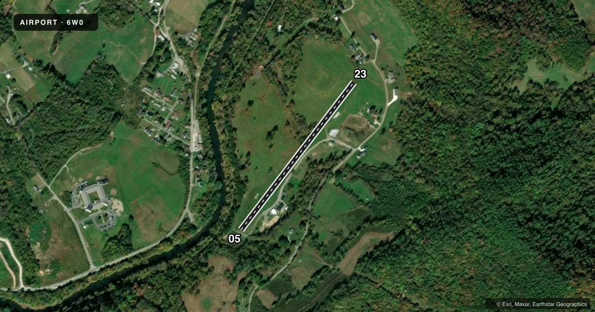
Airport sketch
Runways drawn to scale from FAA survey coordinates, rendered over satellite imagery. Not for navigation.
Approaches & charts
Services on the field
Fuel grades, oxygen, maintenance, ramp storage and lighting — as declared to the FAA by the airport operator.
Fuel & services
- Fuel
- Not available
- Airframe repair
- Minor
- Power plant repair
- Minor
Ramp & ground
- Transient storage
- Tie-down
- Landing fee
- No fee published
- Wind indicator
- Yes
- Segmented circle
- No
Fuel & FBOs
Cheapest 100LL and Jet A on the field and nearby. Always confirm with the FBO before taxi.
Airport notes
Surface conditions, obstructions, local procedures, lighting outages and other notes published with each FAA cycle.
General notes
- APPROACH RWY 23 FROM NW; DEPART RWY 05 TO NW DUE TO RIDGE NE OF ARPT.
- DEER ON & INVOF ARPT.
- RWY 23: 15 FT DROP-OFF 10 FT FM THLD OB.
- RWY 05: 20 FT DROP-OFF 15 FT FM THLD OB.
- RWY 05/23, 20 FT PWR POLES MIDPT OF RWY, 65 FT L & R OF CNTRLN.
- 400 FT RIDGE/TREES 1100 FT FM THLD RY 23 0B.
- HIGH TERRAIN ALL QUADRANTS.
- 15 FT DROP-OFF 45 FT FM CNTRLN FULL LENGTH BOTH SIDES RWY.
- ACFT PARKED 55 FT W OF RWY CNTRLN, APRXLY 1000 FT N OF RWY 5 END.
- FOR CD CTC CLARKSBURG APCH AT 304-842-2011, WHEN APCH CLSD CTC CLEVELAND ARTCC AT 440-774-0226.
- POWER PLANT - 2 STACKS, 1979 MSL, 1009 AGL, 3 MI SW.
Approach & departure obstructions
- 05450 FT HILL, 1/4 MILE NE.
Other notes
- MANAGERALTERNATE PH 304-592-2400.
VFR map & nearby airports
VFR sectional. Tap any ICAO chip to open that airport.
Key facts · 6W0
Answer card- ICAO
- 6W0
- Name
- WADE F MALEY FLD
- Location
- SHINNSTON, WEST VIRGINIA
- Elevation
- 997 ft MSL
- Traffic pattern altitude
- 1,997 ft MSL (1,000 AGL)
- Control tower
- Non-towered (use CTAF)
- Total runways
- 1
- Longest runway
- 05/23 · 2,265 ft
- Published ILS approaches
- 0
- Published frequencies
- 1
- Magnetic variation
- 7°
- Current flight rules
- VFR
- Current wind
- 000° at 0 kt
- Favored runway now
- –
Wade F Maley Fld sits near Shinnston, West Virginia. The field elevation is 997 ft MSL. It has one runway, 05/23, which is 2,265 ft of turf. There is no control tower. CTAF is 122.9. No ILS approaches are published here.
The published pattern altitude is not listed. Use the standard 1,000 ft AGL pattern for light piston operations unless the current Chart Supplement says otherwise. The field sits in high terrain. That matters here. There are hills and ridges in all quadrants. Runway 05 has a hill close in to the northeast. Runway 23 has a drop-off near the threshold. The published remarks also say to approach runway 23 from the northwest. Depart runway 05 to the northwest because of the ridge northeast of the airport.
There are no on-field FBOs listed. Plan on coordinating directly with the airport operator before arrival. Aircraft parking is described west of the runway centerline near the north end. Deer are present on and near the airport. For clearance delivery, the published remarks direct pilots to Clarksburg Approach when it is open. When approach is closed, contact Cleveland ARTCC. Check the current Chart Supplement before you go. This field has terrain, turf and close-in obstacles that deserve a careful briefing.