METAR & TAF 4G7
4G7 does not publish a METAR.
Showing the nearest reporting station: KCKB (NORTH CENTRAL WEST VIRGINIA) · 9.4 NM away. Conditions at 4G7 may differ.
METAR · KCKB
Observed 15:53Z
KCKB 271553Z VRB04KT 10SM SCT019 BKN031 25/20 A2995 RMK AO2 SLP126 T02500200
- Wind
- VAR @ 4 kt
- Visibility
- 10 SM
- Temp / Dew
- 25°C / 20°C
- Altimeter
- 29.95 inHg
- Clouds
- BKN
- Density alt
- 2,443 ft
- Ceiling
- 3,100 ft AGL
- Rules
- VFR
Airport info & contacts
Manager on record, flight service, ARTCC, attendance schedule and pattern altitude — published by the FAA and refreshed every 28 days.
Location
- From city
- 2 NM SW
- VFR sectional
- CINCINNATI
- ARTCC
- ZOB · CLEVELAND
- NOTAM facility
- EKN (NOTAM-D)
Airport manager
- Name
- DONNIE TUCKER
- Phone
- 304-366-1300
- Address
- PO BOX 387, FAIRMONT WV 26555
Flight service · Hours
- FSS EKN
- ELKINS703-724-42881-800-WX-BRIEF
- Attendance
- MON-FRI · 0830-1430
Frequencies
Tap any row to copy the frequency to your clipboard.
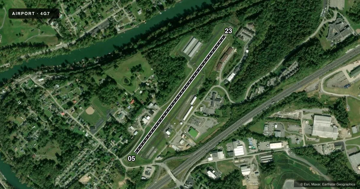
Runways & pattern
Full pagePattern entry · RWY 05
LEFT TRAFFICRunway end performance
| End | TORA | TODA | ASDA | LDA | VGSI | Approach lights | Obstruction |
|---|---|---|---|---|---|---|---|
| 05 | — | — | — | — | — | — | 30', gnd, 201' from thr, 73' R of cntrln, slope 0 |
| 23 | — | — | — | — | — | — | 30', trees, 201' from thr, 240' R of cntrln, slope 0 |
Declared distances in feet. TORA = takeoff run available, TODA = takeoff distance, ASDA = accelerate-stop, LDA = landing distance.
Airport sketch
Runways drawn to scale from FAA survey coordinates, rendered over satellite imagery. Not for navigation.
Approaches & charts
Services on the field
Fuel grades, oxygen, maintenance, ramp storage and lighting — as declared to the FAA by the airport operator.
Fuel & services
- Fuel
- 100LL
- Oxygen (bottled)
- Not available
- Oxygen (bulk)
- Not available
- Airframe repair
- Major
- Power plant repair
- Major
Ramp & ground
- Transient storage
- Tie-down
- Landing fee
- No fee published
- Customs
- Not available
- Lighting schedule
- SEE RMK
- Beacon schedule
- SS-SR
- Beacon
- White / Green (civil land)(WG)
- Wind indicator
- Lighted
- Segmented circle
- No
Fuel & FBOs
Cheapest 100LL and Jet A on the field and nearby. Always confirm with the FBO before taxi.
Airport notes
Surface conditions, obstructions, local procedures, lighting outages and other notes published with each FAA cycle.
General notes
- RADIO TOWERS APRX 300' AGL 2 MILES NE AND 2.5 MILES NW OF ARPT.
- DEER ON & INVOF ARPT.
- RWY 23 HAS 100 FT DROP OFF, NE END.
- RWY 5 HAS +30 FT HILL AT SW END.
- FOR CD CTC CLARKSBURG APCH AT 304-842-2011, WHEN APCH CLSD CTC CLEVELAND ARTCC AT 440-774-0226.
- AFTR HRS ATNDT 304-933-4399 - CALL IN FEE.
Lighting notes
- ACTVT REIL RWY 23; MIRL RWY 5/23 - CTAF.
Approach & departure obstructions
- 05+30 FT HILL 201 FT FM THLD 0B.
- 2312 FT TREES, 199 FT DSTC, 235 R.
- 05APCH RATIO O:1 AT DSPLCD THLD OVR 6 FT FENCE, 0 FT DSTC, 130 FT L. ALSO 15 FT TREES, 270 FT DISTC 70 FT L/R.
- 23ALSO 15 FT TREES, 270 FT DSTCM 70 FT L/R.
Other notes
- MANAGER304-612-4015 MGR CELL
VFR map & nearby airports
VFR sectional. Tap any ICAO chip to open that airport.
Key facts · 4G7
Answer card- ICAO
- 4G7
- Name
- FAIRMONT MUNI-FRANKMAN FLD
- Location
- FAIRMONT, WEST VIRGINIA
- Elevation
- 1,032.4 ft MSL
- Traffic pattern altitude
- 2,032.4 ft MSL (1,000 AGL)
- Control tower
- Non-towered (use CTAF)
- Total runways
- 1
- Longest runway
- 05/23 · 2,965 ft
- Published ILS approaches
- 0
- Published frequencies
- 5
- Magnetic variation
- 9°
- Current flight rules
- VFR
- Current wind
- 000° at 4 kt
- Favored runway now
- RWY 05
Fairmont Muni-Frankman Fld sits in Fairmont, West Virginia. Field elevation is 1,032.4 ft MSL. The airport has one runway. Runway 05/23 is 2,965 ft long and asphalt. There is no control tower. Pattern altitude is not published, so use the standard 1,000 ft AGL for light piston traffic unless the current Chart Supplement says otherwise.
No ILS approaches are published here. CTAF and UNICOM are both 122.8. Clearance delivery is 118.35. Approach and departure are handled by Clarksburg on 121.15 and 284.65. The field is served by Fairmont-Marion County Regional Airport, which carries 100LL. Call ahead if you need current fuel or ramp details.
The published remarks matter here. Runway 23 has a 100 ft drop-off at the northeast end. There are also trees near both runway ends. Runway 05 has a displaced threshold with a fence close in on the left side, plus a hill near the southwest end. Deer are reported on and near the airport. Runway 23 has REILs. Medium intensity runway lights are available on 05 and 23 through CTAF. For a first arrival, pay close attention to the terrain and the runway-end obstacles. This is not a place to rush the approach.