METAR & TAF 79D
79D does not publish a METAR.
Showing the nearest reporting station: KCKB (NORTH CENTRAL WEST VIRGINIA) · 11.0 NM away. Conditions at 79D may differ.
METAR · KCKB
Observed 12:53Z
KCKB 271253Z 00000KT 10SM OVC002 19/19 A2996 RMK AO2 SLP131 T01940189
- Wind
- 000° @ 0 kt
- Visibility
- 10 SM
- Temp / Dew
- 19°C / 19°C
- Altimeter
- 29.96 inHg
- Clouds
- OVC
- Density alt
- 2,607 ft
- Ceiling
- 200 ft AGL
- Rules
- LIFR
Airport info & contacts
Manager on record, flight service, ARTCC, attendance schedule and pattern altitude — published by the FAA and refreshed every 28 days.
Location
- From city
- 2 NM NW
- VFR sectional
- CINCINNATI
- ARTCC
- ZDC · WASHINGTON
- NOTAM facility
- EKN (NOTAM-D)
Airport manager
- Name
- VERLE BROWN
- Phone
- 304-695-0125
- Address
- 26 N. MAIN ST, PHILIPPI WV 26416
Flight service · Hours
- FSS EKN
- ELKINS703-724-42881-800-WX-BRIEF
- Attendance
- Unattended
Frequencies
Tap any row to copy the frequency to your clipboard.
Runways & pattern
Full pagePattern entry · RWY 08
LEFT TRAFFICRunway end performance
| End | TORA | TODA | ASDA | LDA | VGSI | Approach lights | Obstruction |
|---|---|---|---|---|---|---|---|
| 08 | — | — | — | — | PAPI 2-box left(3°) | — | 20', tree, 208' from thr, 70' R of cntrln, slope 0 |
| 26 | — | — | — | — | PAPI 2-box left(3°) | — | 156', gnd, 3200' from thr, 550' R of cntrln, slope 19 |
Declared distances in feet. TORA = takeoff run available, TODA = takeoff distance, ASDA = accelerate-stop, LDA = landing distance.
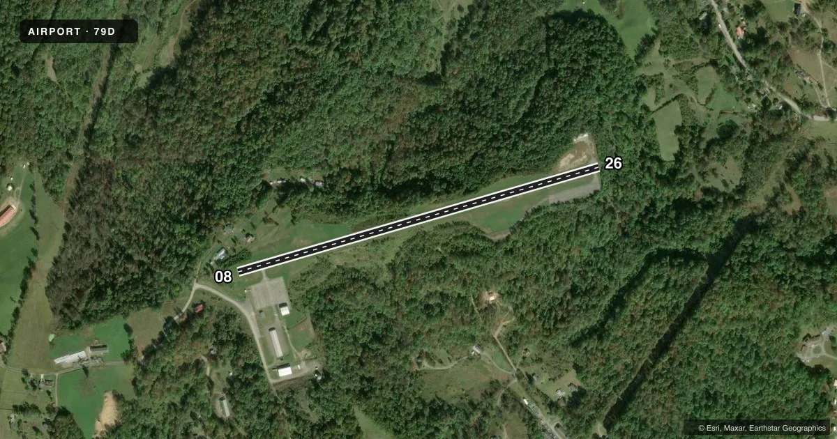
Airport sketch
Runways drawn to scale from FAA survey coordinates, rendered over satellite imagery. Not for navigation.
Approaches & charts
Services on the field
Fuel grades, oxygen, maintenance, ramp storage and lighting — as declared to the FAA by the airport operator.
Fuel & services
- Fuel
- 100LL
- Oxygen (bottled)
- Not available
- Oxygen (bulk)
- Not available
- Airframe repair
- Not available
- Power plant repair
- Not available
Ramp & ground
- Transient storage
- Tie-down
- Landing fee
- No fee published
- Customs
- Not available
- Lighting schedule
- SEE RMK
- Beacon schedule
- SS-SR
- Beacon
- White / Green (civil land)(WG)
- Wind indicator
- Lighted
- Segmented circle
- Yes
Fuel & FBOs
Cheapest 100LL and Jet A on the field and nearby. Always confirm with the FBO before taxi.
Airport notes
Surface conditions, obstructions, local procedures, lighting outages and other notes published with each FAA cycle.
General notes
- RWY 26 500 FT DROP-OFF 50 FT FM THR.
- RWY 08 150 FT DROP-OFF 112 FT FM THR.
- WILDLIFE INVOF ARPT.
- AIRPORT FENCED. VEHICLE GATE LOCKED. ONLY ACCESS VIA PEDESTRIAN GATE.
- FOR CD CTC WASHINGTON ARTCC AT 703-771-3587.
Lighting notes
- DUSK-DAWN. ACTIVATE REIL RWY 08; PAPI RWYS 08 & 26; MIRL RWY 08/26 - CTAF.
Fuel notes
- 100LL24 HR. SELF SERVE.
Approach & departure obstructions
- 0820 FT TREES, 0-120 FT DSTC, 45 FT L.
- 2620 FT TREES 0-30 FT DSTC 50 FT R/L.
- 08OMNIDIRECTIONAL REILS.
- 08APCH RATIO 0:1 AT DSPLCD THR OVR 30 FT TREES, 0 FT DSTC, 45 FT L.
- 26APCH RATIO 0:1 AT DSPLCD THR OVR 30 FT TREES, 0 FT DSTC 199 FT R, 245 FT L.
- 26186 FT RIDGE APRXLY 3200 FT FM THR; 550 FT R.
Other notes
- PRVDD TREES OFF THE APCH END OF RWY 26 ARE REMOVED OR TRIMMED TO REMAIN BLO 20:1 APCH SURFACE.
- OWNEREXT 2
VFR map & nearby airports
VFR sectional. Tap any ICAO chip to open that airport.
Key facts · 79D
Answer card- ICAO
- 79D
- Name
- PHILIPPI/BARBOUR COUNTY RGNL
- Location
- PHILIPPI, WEST VIRGINIA
- Elevation
- 1,755.4 ft MSL
- Traffic pattern altitude
- 2,755.4 ft MSL (1,000 AGL)
- Control tower
- Non-towered (use CTAF)
- Total runways
- 1
- Longest runway
- 08/26 · 3,275 ft
- Published ILS approaches
- 0
- Published frequencies
- 3
- Magnetic variation
- 9°
- Current flight rules
- LIFR
- Current wind
- 000° at 0 kt
- Favored runway now
- –
Philippi/Barbour County Regional Airport sits in Philippi, West Virginia. The field elevation is 1,755.4 ft MSL. It has one runway, 08/26, which is 3,275 ft long on asphalt. There is no control tower. Pattern altitude is not published, so plan on the standard 1,000 ft AGL pattern unless the current FAA Chart Supplement says otherwise. That puts the light piston pattern at about 2,755 ft MSL.
No ILS approaches are published here. CTAF is 122.9. Approach and departure service is with Clarksburg on 121.15 and 284.65. The airport is fenced. The vehicle gate is locked. Access is through the pedestrian gate only.
The on-field FBO is Philippi-Barbour County Regional Airport. It carries 100LL. Self-serve fuel is available 24 hours. Published remarks matter here. Runway 26 has a steep drop-off near the threshold. Runway 08 has trees close to the approach end and more drop-off beyond the threshold. Wildlife is also reported in the area. Lighting is available from dusk to dawn. Use CTAF to activate the runway end identifier lights, the PAPI and the medium intensity runway lights. This is a small non-towered field with terrain and obstacle awareness that deserves a careful arrival brief.