METAR & TAF KCKB
Current METAR
Observed 12:53Z
KCKB 271253Z 00000KT 10SM OVC002 19/19 A2996 RMK AO2 SLP131 T01940189
- Wind
- 000° @ 0 kt
- Visibility
- 10 SM
- Temp / Dew
- 19°C / 19°C
- Altimeter
- 29.96 inHg
- Clouds
- OVC
- Density alt
- 1,948 ft
- Ceiling
- 200 ft AGL
- Rules
- LIFR
Airport info & contacts
Manager on record, flight service, ARTCC, attendance schedule and pattern altitude — published by the FAA and refreshed every 28 days.
Location
- From city
- 1 NM NE
- VFR sectional
- CINCINNATI
- ARTCC
- ZOB · CLEVELAND
- NOTAM facility
- CKB (NOTAM-D)
Airport manager
- Name
- RICK ROCK
- Phone
- 304-842-3400
- Address
- 2000 AVIATION WAY, BRIDGEPORT WV 26330
Flight service · Hours
- FSS EKN
- ELKINS703-724-42881-800-WX-BRIEF
- Attendance
- 0700-2300
Frequencies
Tap any row to copy the frequency to your clipboard.
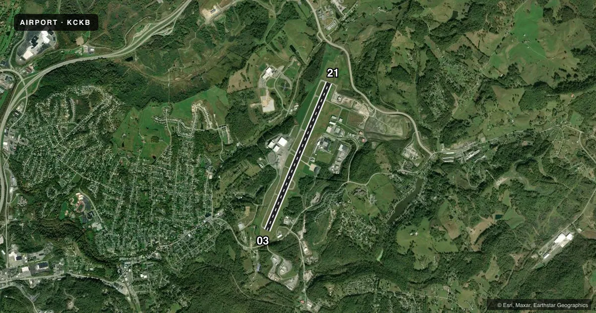
Runways & pattern
Full pagePattern entry · RWY 03
LEFT TRAFFICRunway end performance
| End | TORA | TODA | ASDA | LDA | VGSI | Approach lights | Obstruction |
|---|---|---|---|---|---|---|---|
| 03 | 7,800' | 7,800' | 7,800' | 7,130' | PAPI 4-box left(3.44°) | — | 43', trees, 600' from thr, 525' R of cntrln, slope 9 |
| 21 | 7,800' | 7,800' | 7,130' | 7,130' | PAPI 4-box left(3°) | MALSR | 189', trees, 6500' from thr, 300' R of cntrln, slope 33 |
Declared distances in feet. TORA = takeoff run available, TODA = takeoff distance, ASDA = accelerate-stop, LDA = landing distance.
Airport sketch
Runways drawn to scale from FAA survey coordinates, rendered over satellite imagery. Not for navigation.
Approaches & charts
ILS · 1
Services on the field
Fuel grades, oxygen, maintenance, ramp storage and lighting — as declared to the FAA by the airport operator.
Fuel & services
- Fuel
- 100LLA
- Oxygen (bottled)
- Not available
- Oxygen (bulk)
- Not available
- Airframe repair
- Major
- Power plant repair
- Major
- Other services
- AFRT,AVNCS,CHTR,INSTR
Ramp & ground
- Transient storage
- Tie-down
- Hangar
- Landing fee
- Yes
- Customs
- Not available
- Lighting schedule
- SEE RMK
- Beacon schedule
- SS-SR
- Beacon
- White / Green (civil land)(WG)
- Wind indicator
- Lighted
Fuel & FBOs
Cheapest 100LL and Jet A on the field and nearby. Always confirm with the FBO before taxi.
Airport notes
Surface conditions, obstructions, local procedures, lighting outages and other notes published with each FAA cycle.
General notes
- DEER & BIRDS ON & INVOF ARPT.
- AFT HRS FOR EMERGS CALL 304-623-6559.
- FOR CD CTC CLARKSBURG APCH AT 304-842-2011, WHEN APCH CLSD CTC CLEVELAND ARTCC AT 440-774-0226.
- TWY A SOUTH OF TWY C, MAIN TRML APRON, AND HELIPAD NOT VSBL FROM TWR.
- 24 PPR FOR PRK ON ARNG RAMP DSN 661-3800 C304-201-3800.
- TWY H E OF TWY H1 CLSD TO TRAN ACFT.
- CTLNG OBSTN SLOPE AT DSPLCD LOCATION RWY 03 IS 29:1.
Lighting notes
- ACTVT MALSR RWY 21; REIL RWY 03; PAPI RWY 03 & 21; AND HIRL RWY 3/21 ON CTAF.
Fuel notes
- 100LLFUEL NOT AVBL DURG HRS 2300-0500.
Runway surface & condition
- 03/21PCR VALUE: 4200/F/A/X/T
Other notes
- PPR 24 HRS FOR UNSKED ACR OPNS WITH MORE THAN 30 PSGR SEATS CALL AMGR 304-842-3400 OR 304-848-6700.
- LNDG FEE FOR ALL ACFT OVER 6500 LBS.
- CHTRCREW CAR AVBL.
- H1HELI, H-1 SFC COND FAIR, PAVEMENT CRACKING.
VFR map & nearby airports
VFR sectional. Tap any ICAO chip to open that airport.
Key facts · KCKB
Answer card- ICAO
- KCKB
- Name
- NORTH CENTRAL WEST VIRGINIA
- Location
- CLARKSBURG, WEST VIRGINIA
- Elevation
- 1,223.5 ft MSL
- Traffic pattern altitude
- 2,223.5 ft MSL (1,000 AGL)
- Control tower
- Towered · 0700-2300
- Total runways
- 1
- Longest runway
- 03/21 · 7,800 ft
- Published ILS approaches
- 1
- Published frequencies
- 10
- Magnetic variation
- 8°
- Current flight rules
- LIFR
- Current wind
- 000° at 0 kt
- Favored runway now
- –
North Central West Virginia Airport sits in Clarksburg, West Virginia. Field elevation is 1,223.5 ft MSL. The airport has one runway, 03/21, which is 7,800 ft long. The tower is open daily from 0700 to 2300. There is one ILS approach. It serves runway 21. Pattern altitude is not published. Use the standard 1,000 ft AGL for light piston traffic unless ATC or local procedures say otherwise.
V1 Aviation is on the field. It carries 100LL, Jet A and Jet A Prist. Fuel is not available from 2300 to 0500. The published remarks also note that taxiway H east of H1 is closed to transient aircraft. That matters for taxi planning on the ground. Runway 21 has MALSR lighting. Runway 03 has REILs. PAPI is installed on both runway ends. High intensity runway lights on 03/21 operate on CTAF.
This is a towered field with approach control in the area. Expect normal IFR coordination and busy radio work. The airport also notes a displaced threshold obstruction slope on runway 03. Check the current FAA Chart Supplement before departure for any updated local procedures, ramp restrictions, or operational notes. If you need parking or ramp access details, call the airport operator or V1 Aviation directly before you go.