METAR & TAF 70D
70D does not publish a METAR.
Showing the nearest reporting station: KMGW (MORGANTOWN MUNI/WALTER L BILL HART FLD) · 9.2 NM away. Conditions at 70D may differ.
METAR · KMGW
Observed 16:53Z
KMGW 261653Z 23008KT 10SM SCT036 BKN046 25/16 A2997 RMK AO2 SLP141 T02500161
- Wind
- 230° @ 8 kt
- Visibility
- 10 SM
- Temp / Dew
- 25°C / 16°C
- Altimeter
- 29.97 inHg
- Clouds
- BKN
- Density alt
- 3,448 ft
- Ceiling
- 4,600 ft AGL
- Rules
- VFR
Airport info & contacts
Manager on record, flight service, ARTCC, attendance schedule and pattern altitude — published by the FAA and refreshed every 28 days.
Location
- From city
- 2 NM W
- VFR sectional
- CINCINNATI
- ARTCC
- ZOB · CLEVELAND
- NOTAM facility
- EKN (NOTAM-D)
Airport manager
- Name
- JEAN KRASCO
- Phone
- 304-864-6996
- Address
- 1827 STONY RUN RD., INDEPENDENCE WV 26734
Flight service · Hours
- FSS EKN
- ELKINS703-724-42881-800-WX-BRIEF
- Attendance
- Unattended
Frequencies
Tap any row to copy the frequency to your clipboard.
Runways & pattern
Full pagePattern entry · RWY 27
LEFT TRAFFICRunway end performance
| End | TORA | TODA | ASDA | LDA | VGSI | Approach lights | Obstruction |
|---|---|---|---|---|---|---|---|
| 09 | — | — | — | — | — | — | 55', trees, 0' from thr, 125' R of cntrln, slope 0 |
| 27 | — | — | — | — | — | — | 55', tree, 0' from thr, 104' R of cntrln, slope 0 |
Declared distances in feet. TORA = takeoff run available, TODA = takeoff distance, ASDA = accelerate-stop, LDA = landing distance.
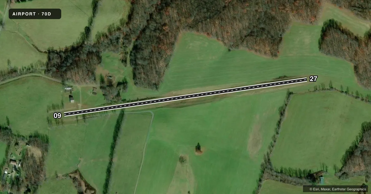
Airport sketch
Runways drawn to scale from FAA survey coordinates, rendered over satellite imagery. Not for navigation.
Approaches & charts
Services on the field
Fuel grades, oxygen, maintenance, ramp storage and lighting — as declared to the FAA by the airport operator.
Fuel & services
- Fuel
- Not available
- Oxygen (bottled)
- Not available
- Oxygen (bulk)
- Not available
- Airframe repair
- Not available
- Power plant repair
- Not available
Ramp & ground
- Transient storage
- Not published
- Landing fee
- No fee published
- Wind indicator
- Yes
- Segmented circle
- No
Fuel & FBOs
Cheapest 100LL and Jet A on the field and nearby. Always confirm with the FBO before taxi.
Airport notes
Surface conditions, obstructions, local procedures, lighting outages and other notes published with each FAA cycle.
General notes
- 25 FT TREES ALONG EDGE OF RWY.
- DEER ON & INVOF RWY.
- RWY 09/27 POTENTIALLY HAZARDOUS SFC VARIATION IN RWY SAFETY AREA.
- RWY 27 - 8 FT DROPOFF 25 FT FM THR 0B.
- ULTRALIGHTS PROHIBITED.
- FOR CD CTC CLARKSBURG APCH AT 304-842-2011, WHEN APCH CLSD CTC CLEVELAND ARTCC AT 440-774-0226.
Approach & departure obstructions
- 09ALSO 60 FT TREES, 395 FT DSTC, 6:1.
Other notes
- OWNER973-896-8293 CELL
- 09/27SFC ROUGH, SOFT WHEN WET.
VFR map & nearby airports
VFR sectional. Tap any ICAO chip to open that airport.
Key facts · 70D
Answer card- ICAO
- 70D
- Name
- TITUS FLD
- Location
- ARTHURDALE, WEST VIRGINIA
- Elevation
- 1,863 ft MSL
- Traffic pattern altitude
- 2,863 ft MSL (1,000 AGL)
- Control tower
- Non-towered (use CTAF)
- Total runways
- 1
- Longest runway
- 09/27 · 2,400 ft
- Published ILS approaches
- 0
- Published frequencies
- 1
- Magnetic variation
- 7°
- Current flight rules
- VFR
- Current wind
- 230° at 8 kt
- Favored runway now
- RWY 27
Titus Fld is in Arthurdale, West Virginia. The field elevation is 1,863 ft MSL. It has one runway, 09/27, which is 2,400 ft of turf. The runway headings are 82° and 262° magnetic. There is no control tower. CTAF is 122.9.
No ILS approaches are published here. The pattern altitude is not published, so use the standard 1,000 ft AGL for light piston operations unless the current Chart Supplement says otherwise. This is a small field with a turf surface, so plan for a short-field mindset. The Chart Supplement remarks matter here. The runway edge has 25 ft trees. Deer are reported on and near the runway. The surface is rough and soft when wet. There is also potentially hazardous surface variation in the runway safety area. Runway 27 has an 8 ft dropoff 25 ft from threshold 0B. Trees 60 ft high are reported 395 ft from runway 09 with a 6 to 1 clearance slope issue.
No on-field FBOs are listed. Check the current Chart Supplement or call the airport operator before you go. For clearance delivery, contact Clarksburg Approach at 304-842-2011. When approach is closed, contact Cleveland ARTCC at 440-774-0226. Ultralights are prohibited.