METAR & TAF KMGW
Current METAR
Observed 16:07Z
KMGW 271607Z VRB05KT 10SM SCT012 SCT039 24/20 A2996 RMK AO2 T02390200
- Wind
- VAR @ 5 kt
- Visibility
- 10 SM
- Temp / Dew
- 24°C / 20°C
- Altimeter
- 29.96 inHg
- Clouds
- SCT
- Density alt
- 2,573 ft
- Ceiling
- Unlimited
- Rules
- VFR
Airport info & contacts
Manager on record, flight service, ARTCC, attendance schedule and pattern altitude — published by the FAA and refreshed every 28 days.
Location
- From city
- 3 NM E
- VFR sectional
- CINCINNATI
- ARTCC
- ZOB · CLEVELAND
- NOTAM facility
- MGW (NOTAM-D)
Airport manager
- Name
- EMILY MUZZARELLI
- Phone
- 304-284-7406
- Address
- 100 HART FIELD RD, MORGANTOWN WV 26505
Flight service · Hours
- FSS EKN
- ELKINS703-724-42881-800-WX-BRIEF
- Attendance
- MON-FRI · 0500-0000
- SAT-SUN · 0500-2300
Frequencies
Tap any row to copy the frequency to your clipboard.
Runways & pattern
Full pagePattern entry · RWY 36
LEFT TRAFFICRunway end performance
| End | TORA | TODA | ASDA | LDA | VGSI | Approach lights | Obstruction |
|---|---|---|---|---|---|---|---|
| 18 | 5,199' | 5,199' | 5,199' | 5,199' | PAPI 4-box left(3°) | MALSR | — |
| 36 | 5,199' | 5,199' | 5,199' | 5,199' | VASI 4-box left(3°) | — | — |
Declared distances in feet. TORA = takeoff run available, TODA = takeoff distance, ASDA = accelerate-stop, LDA = landing distance.
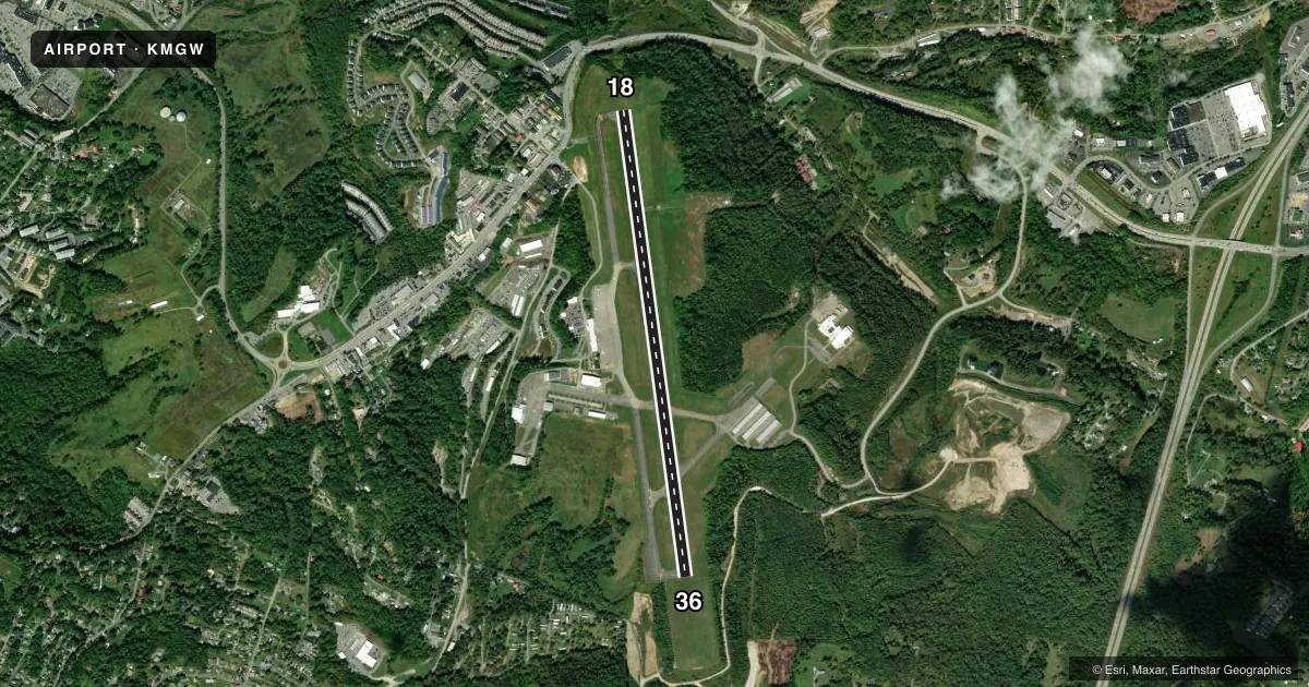
Airport sketch
Runways drawn to scale from FAA survey coordinates, rendered over satellite imagery. Not for navigation.
Approaches & charts
ILS · 1
Services on the field
Fuel grades, oxygen, maintenance, ramp storage and lighting — as declared to the FAA by the airport operator.
Fuel & services
- Fuel
- 100LLAA+
- Oxygen (bottled)
- Not available
- Oxygen (bulk)
- Not available
- Airframe repair
- Minor
- Power plant repair
- Minor
- Other services
- AMB,CHTR,INSTR,SURV
Ramp & ground
- Transient storage
- Tie-down
- Hangar
- Landing fee
- Yes
- Customs
- Not available
- Lighting schedule
- SEE RMK
- Beacon schedule
- SS-SR
- Beacon
- White / Green (civil land)(WG)
- Wind indicator
- Lighted
- Segmented circle
- No
Fuel & FBOs
Cheapest 100LL and Jet A on the field and nearby. Always confirm with the FBO before taxi.
Airport notes
Surface conditions, obstructions, local procedures, lighting outages and other notes published with each FAA cycle.
General notes
- DEER & BIRDS ON & INVOF ARPT.
- FBO HRS MON-FRI 0500-0000, SAT-SUN 0500-2300. 24-HR PHONE NR 304-296-2359.
- BE ALERT: POSSIBILITY OF TURBULENCE INVOF POWER PLANT STACKS 3.6 MILES N OF AFLD DURG COLD WEATHER.
- FOR CD CTC CLARKSBURG APCH AT 304-842-2011, WHEN APCH CLSD CTC CLEVELAND ARTCC AT 440-774-0226.
Lighting notes
- WHEN ATCT CLSD ACTVT MALSR RWY 18; REIL RWY 36; VASI RWY 36; HIRL RWY 18/36; TWY LGTS - CTAF.
Runway surface & condition
- 18/36PCR VALUE: 340/F/C/W/T
Other notes
- PPR 24 HRS FOR UNSCHEDULED ACR OPNS, CALL AMGR 304-291-7461.
- LNDG FEE FOR ACFT 5000 LBS & OVER.
VFR map & nearby airports
VFR sectional. Tap any ICAO chip to open that airport.
Key facts · KMGW
Answer card- ICAO
- KMGW
- Name
- MORGANTOWN MUNI/WALTER L BILL HART FLD
- Location
- MORGANTOWN, WEST VIRGINIA
- Elevation
- 1,243.7 ft MSL
- Traffic pattern altitude
- 2,243.7 ft MSL (1,000 AGL)
- Control tower
- Towered · 0700-2300
- Total runways
- 1
- Longest runway
- 18/36 · 5,199 ft
- Published ILS approaches
- 1
- Published frequencies
- 7
- Magnetic variation
- 9°
- Current flight rules
- VFR
- Current wind
- 000° at 5 kt
- Favored runway now
- RWY 36
Morgantown Muni/Walter L Bill Hart Fld sits in Morgantown, West Virginia. Field elevation is 1,243.7 ft MSL. The airport has one runway. Runway 18/36 is 5,199 ft of asphalt. The tower is open daily from 0700 to 2300. One ILS approach is published for runway 18.
Pattern altitude is not published in the facts. Use the current FAA Chart Supplement before you go. The field is served by Morgantown Municipal Airport on the field. It carries 100LL, Jet A and Jet A Prist. Call ahead if you need current service details. The published remarks also say the airport uses CTAF to activate runway and taxiway lighting when the tower is closed.
This is a controlled field with published approach control and ground frequencies. Expect normal towered-airport procedures. The remarks also call out deer and birds on and near the airport. Cold weather can bring turbulence near power plant stacks 3.6 miles north of the field. Aircraft 5,000 lb and over are subject to a landing fee. Unscheduled operations need prior permission 24 hours in advance. For a first visit, verify the current Chart Supplement, then call the airport manager or the FBO directly if you need anything operational before arrival.