METAR & TAF KVVS
Current METAR
Observed 12:35Z
KVVS 271235Z AUTO 25004KT 7SM BR OVC009 19/19 A2996 RMK AO2 T01920188
- Wind
- 250° @ 4 kt
- Visibility
- 7 SM
- Temp / Dew
- 19°C / 19°C
- Altimeter
- 29.96 inHg
- Clouds
- OVC
- Density alt
- 1,998 ft
- Ceiling
- 900 ft AGL
- Rules
- IFR
Airport info & contacts
Manager on record, flight service, ARTCC, attendance schedule and pattern altitude — published by the FAA and refreshed every 28 days.
Location
- From city
- 5 NM SW
- VFR sectional
- CINCINNATI
- ARTCC
- ZOB · CLEVELAND
- NOTAM facility
- AOO (NOTAM-D)
Airport manager
- Name
- JOHN NECKERAUER
- Phone
- 724-628-2276
- Address
- 988 SKY DRIVE, LEMONT FURNACE PA 15456
Flight service · Hours
- FSS AOO
- ALTOONA1-800-WX-BRIEF
- Attendance
- 0800 - 1700
Frequencies
Tap any row to copy the frequency to your clipboard.
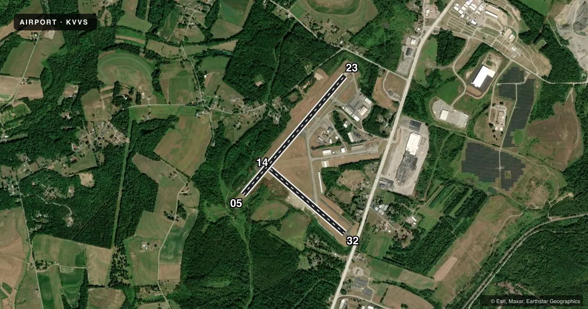
Runways & pattern
Full pagePattern entry · RWY 23
LEFT TRAFFIC| Runway | Heading (°M) | Length | Surface | Traffic |
|---|---|---|---|---|
| 05/23Favored | 33° / 213° | 3,833 ft | ASPH | Standard L |
| 14/32 | 123° / 303° | 2,404 ft | ASPH | Standard L |
Runway end performance
| End | TORA | TODA | ASDA | LDA | VGSI | Approach lights | Obstruction |
|---|---|---|---|---|---|---|---|
| 05 | — | — | — | — | PAPI 2-box left(3°) | — | — |
| 23 | — | — | — | — | PAPI 2-box right(3°) | — | — |
| 14 | — | — | — | — | PAPI 2-box left(3°) | — | 48', trees, 999' from thr, 128' R of cntrln, slope 16 |
| 32 | — | — | — | — | — | — | 13', trees, 339' from thr, 110' R of cntrln, slope 10 |
Declared distances in feet. TORA = takeoff run available, TODA = takeoff distance, ASDA = accelerate-stop, LDA = landing distance.
Airport sketch
Runways drawn to scale from FAA survey coordinates, rendered over satellite imagery. Not for navigation.
Approaches & charts
ILS · 1
Services on the field
Fuel grades, oxygen, maintenance, ramp storage and lighting — as declared to the FAA by the airport operator.
Fuel & services
- Fuel
- 100LLA
- Airframe repair
- Major
- Power plant repair
- Major
- Other services
- AMB,RNTL
Ramp & ground
- Transient storage
- Tie-down
- Hangar
- Landing fee
- Yes
- Customs
- Not available
- Lighting schedule
- SEE RMK
- Beacon schedule
- SS-SR
- Beacon
- White / Green (civil land)(WG)
- Wind indicator
- Lighted
- Segmented circle
- Yes
Fuel & FBOs
Cheapest 100LL and Jet A on the field and nearby. Always confirm with the FBO before taxi.
Airport notes
Surface conditions, obstructions, local procedures, lighting outages and other notes published with each FAA cycle.
General notes
- RWY 23 HAS A 265 FT RELOCATED THR FOR TAXI ONLY. RWY 14 HAS A 315 FT RELOCATED THR FOR TAXI ONLY, RWY 32 HAS A 260 FT RELOCATED THR FOR TAXI ONLY.
- DEER & BIRDS ON & INVOF ARPT.
- TWY B CLSD TO ACFT WITH WINGSPAN MORE THAN 40 FT.
- FOR CD CTC CLARKSBURG APCH AT 304-842-2011, WHEN APCH CLSD CTC CLEVELAND ARTCC AT 440-774-0226.
- RWY 14/32: CLSD SS TO SR.
Lighting notes
- ACTVT REIL RWY 05; PAPI RWY 05, 23 & 14. MIRL RWY 05/23 & 14/32 - CTAF.
Fuel notes
- 100LLSELF SVC 100LL AVBL 24 HRS; CREDIT CARD ONLY.
Runway surface & condition
- 14/32THLD & EDGE LGT OTS INDEF.
Approach & departure obstructions
- 0516 FT TREES; 282 FT FM RWY END, 127 FT RIGHT. 8 FT TREES; 157 FT FM RWY END, 116 FT LEFT. 12 FT TREES; 271 FT FM RWY, 105 FT LEFT.
- 14PAPI OTS INDEF.
Other notes
- IN OPER PRIOR TO 1959.
- LDG FEE FOR ALL ACFT OVER 6000 LBS GWT; WAIVED FOR FUEL PURCHASE.
- MANAGERAFT HRS 412-916-6282.
VFR map & nearby airports
VFR sectional. Tap any ICAO chip to open that airport.
Key facts · KVVS
Answer card- ICAO
- KVVS
- Name
- JOSEPH A HARDY CONNELLSVILLE
- Location
- CONNELLSVILLE, PENNSYLVANIA
- Elevation
- 1,264.4 ft MSL
- Traffic pattern altitude
- 2,264.4 ft MSL (1,000 AGL)
- Control tower
- Non-towered (use CTAF)
- Total runways
- 2
- Longest runway
- 05/23 · 3,833 ft
- Published ILS approaches
- 1
- Published frequencies
- 4
- Magnetic variation
- 8°
- Current flight rules
- IFR
- Current wind
- 250° at 4 kt
- Favored runway now
- RWY 23
Joseph A Hardy Connellsville Airport sits in Connellsville, Pennsylvania. The field elevation is 1,264.4 ft MSL. It has two asphalt runways. The longest is 3,833 ft on runway 05/23. There is one ILS approach. It is for runway 05. The airport is not towered. CTAF is 122.8. Clarksburg Approach handles clearance delivery. When approach is closed, contact Cleveland ARTCC.
Pattern altitude is not published. Use 1,000 ft AGL for light piston traffic unless the current Chart Supplement says otherwise. Deer and birds are reported on and near the field. Keep a sharp scan on climbout and final. Runway 05 has nearby tree obstructions off the departure end. Runway 14/32 is closed from sunset to sunrise. Its threshold and edge lighting are out of service indefinitely. Plan day use only on that strip until the status changes.
Connellsville Airport is on the field. It carries 100LL, Jet A and Jet A Prist. Self-serve 100LL is available 24 hours with credit card only. The airport also has PAPI on runways 05, 23 and 14. Medium intensity runway lighting is installed on 05/23 and 14/32. Taxiway B is closed to aircraft with wingspan over 40 ft. The airport has an after-hours contact number if you need the manager.