METAR & TAF 2G4
Current METAR
Observed 13:35Z
K2G4 271335Z AUTO VRB04KT 3SM BR BKN003 BKN007 18/18 A3001 RMK AO2
- Wind
- VAR @ 4 kt
- Visibility
- 3 SM
- Temp / Dew
- 18°C / 18°C
- Altimeter
- 30.01 inHg
- Clouds
- BKN
- Density alt
- 3,886 ft
- Ceiling
- 300 ft AGL
- Rules
- LIFR
Airport info & contacts
Manager on record, flight service, ARTCC, attendance schedule and pattern altitude — published by the FAA and refreshed every 28 days.
Location
- From city
- 13 NM NE
- VFR sectional
- CINCINNATI
- Pattern altitude
- 800 ft AGL · 3,733 ft MSL
- ARTCC
- ZOB · CLEVELAND
- NOTAM facility
- EKN (NOTAM-D)
Airport manager
- Name
- ADISON WYER
- Phone
- 301-746-8599
- Address
- 771 AIRPORT ROAD, ACCIDENT MD 21520
Flight service · Hours
- FSS EKN
- ELKINS703-724-42881-800-WX-BRIEF
- Attendance
- 0800-1700
Frequencies
Tap any row to copy the frequency to your clipboard.
Runways & pattern
Full pagePattern entry · RWY 09
LEFT TRAFFICRunway end performance
| End | TORA | TODA | ASDA | LDA | VGSI | Approach lights | Obstruction |
|---|---|---|---|---|---|---|---|
| 09 | — | — | — | — | PAPI 4-box left(3°) | — | — |
| 27 | — | — | — | — | PAPI 4-box left(3°) | — | — |
Declared distances in feet. TORA = takeoff run available, TODA = takeoff distance, ASDA = accelerate-stop, LDA = landing distance.
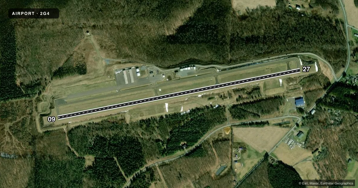
Airport sketch
Runways drawn to scale from FAA survey coordinates, rendered over satellite imagery. Not for navigation.
Approaches & charts
Services on the field
Fuel grades, oxygen, maintenance, ramp storage and lighting — as declared to the FAA by the airport operator.
Fuel & services
- Fuel
- 100LLA+
- Oxygen (bottled)
- Not available
- Oxygen (bulk)
- Not available
- Airframe repair
- Minor
- Power plant repair
- Not available
- Other services
- CHTR
Ramp & ground
- Transient storage
- Tie-down
- Landing fee
- No fee published
- Customs
- Not available
- Lighting schedule
- SEE RMK
- Beacon schedule
- SS-SR
- Beacon
- White / Green (civil land)(WG)
- Wind indicator
- Lighted
- Segmented circle
- Yes
Fuel & FBOs
Cheapest 100LL and Jet A on the field and nearby. Always confirm with the FBO before taxi.
Airport notes
Surface conditions, obstructions, local procedures, lighting outages and other notes published with each FAA cycle.
General notes
- WILDLIFE ON AND INVOF ARPT.
- FOR CD CTC CLARKSBURG APCH AT 304-842-2011, WHEN APCH CLSD CTC CLEVELAND ARTCC AT 440-774-0226.
Lighting notes
- ACTVT REIL RWY 09 & 27; PAPI RWY 09 & 27; MIRL RWY 09/27 - CTAF.
Fuel notes
- 100LL24 HR SELF SERVE 100LL AND JET-A, W/PRIST AVBL WITH CREDIT CARD.
Other notes
- THIS AIRPORT HAS BEEN SURVEYED BY THE NATIONAL GEODETIC SURVEY.
- 2UNATNDD CHRISTMAS AND NEW YEARS DAY.
- MANAGERMGR EMERG NR (301) 616-7467.
VFR map & nearby airports
VFR sectional. Tap any ICAO chip to open that airport.
Key facts · 2G4
Answer card- ICAO
- 2G4
- Name
- GARRETT COUNTY
- Location
- OAKLAND, MARYLAND
- Elevation
- 2,933.4 ft MSL
- Traffic pattern altitude
- 3,733.4 ft MSL (800 AGL)
- Control tower
- Non-towered (use CTAF)
- Total runways
- 1
- Longest runway
- 09/27 · 5,000 ft
- Published ILS approaches
- 0
- Published frequencies
- 4
- Magnetic variation
- 9°
- Current flight rules
- LIFR
- Current wind
- 000° at 4 kt
- Favored runway now
- RWY 09
Garrett County Airport sits in Oakland, Maryland. The field elevation is 2,933.4 ft MSL. It has one runway. The longest runway is 09/27 at 5,000 ft. There is no control tower. Pattern altitude is 800 ft AGL, which is 3,733.4 ft MSL.
No ILS approaches are published here. If you are planning an arrival, use the current FAA Chart Supplement for the latest approach and airport notes. The airport is in the mountains of western Maryland. Expect higher density altitude than a low-elevation field, especially in warm weather. Wildlife is also present on and near the airport.
The on-field FBO is Garrett County Airport. It carries 100LL and Jet-A with Prist. Twenty-four hour self-serve fuel is available by credit card. Runway end identifier lights are on 09 and 27. PAPI is available on both ends. Medium intensity runway lights are controlled by CTAF.
For clearance delivery, contact Clarksburg Approach. When Clarksburg Approach is closed, contact Cleveland ARTCC. This is a non-towered field, so plan your radio work and runway checks early. Check the current Chart Supplement for any published noise or curfew restrictions before flying into the field.