METAR & TAF 1W3
1W3 does not publish a METAR.
Showing the nearest reporting station: KCBE (GREATER CUMBERLAND RGNL) · 0.6 NM away. Conditions at 1W3 may differ.
METAR · KCBE
Observed 17:15Z
KCBE 271715Z AUTO 28005KT 10SM BKN049 SCT055 SCT065 29/18 A2992 RMK AO2 T02900177
- Wind
- 280° @ 5 kt
- Visibility
- 10 SM
- Temp / Dew
- 29°C / 18°C
- Altimeter
- 29.92 inHg
- Clouds
- BKN
- Density alt
- 2,433 ft
- Ceiling
- 4,900 ft AGL
- Rules
- VFR
Airport info & contacts
Manager on record, flight service, ARTCC, attendance schedule and pattern altitude — published by the FAA and refreshed every 28 days.
Location
- From city
- 3 NM S
- VFR sectional
- WASHINGTON
- Pattern altitude
- 800 ft AGL · 1,407 ft MSL
- ARTCC
- ZOB · CLEVELAND
- NOTAM facility
- EKN (NOTAM-D)
Airport manager
- Name
- DONALD JOHNSON JR.
- Phone
- 301-724-5231
- Address
- 11107 MEXICO FARMS, CUMBERLAND MD 21502
Flight service · Hours
- FSS EKN
- ELKINS703-724-42881-800-WX-BRIEF
- Attendance
- UNATTNDD
Frequencies
Tap any row to copy the frequency to your clipboard.
Runways & pattern
Full pagePattern entry · RWY 27
LEFT TRAFFICRunway end performance
| End | TORA | TODA | ASDA | LDA | VGSI | Approach lights | Obstruction |
|---|---|---|---|---|---|---|---|
| 27 | — | — | — | — | — | — | 81', trees, 832' from thr, 176' R of cntrln, slope 10 |
Declared distances in feet. TORA = takeoff run available, TODA = takeoff distance, ASDA = accelerate-stop, LDA = landing distance.
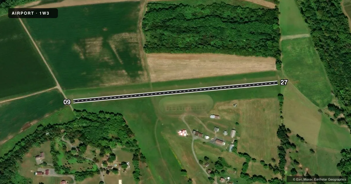
Airport sketch
Runways drawn to scale from FAA survey coordinates, rendered over satellite imagery. Not for navigation.
Approaches & charts
Services on the field
Fuel grades, oxygen, maintenance, ramp storage and lighting — as declared to the FAA by the airport operator.
Fuel & services
- Fuel
- Not available
- Oxygen (bottled)
- Not available
- Oxygen (bulk)
- Not available
- Airframe repair
- Not available
- Power plant repair
- Not available
Ramp & ground
- Transient storage
- Tie-down
- Landing fee
- No fee published
- Customs
- Not available
- Wind indicator
- Lighted
- Segmented circle
- No
Fuel & FBOs
Cheapest 100LL and Jet A on the field and nearby. Always confirm with the FBO before taxi.
Airport notes
Surface conditions, obstructions, local procedures, lighting outages and other notes published with each FAA cycle.
General notes
- ULTRALIGHT ACFT & WILDLIFE ON & INVOF ARPT.
- RISING TRRN 4500 FT W OF ARPT.
- FOR CD CTC JOHNSTOWN APCH AT 814-532-5960, WHEN APCH CLSD CTC CLEVELAND ARTCC AT 440-774-0213.
Approach & departure obstructions
- 27DSPLCD THR MKD WITH CONES ON BOTH SIDES.
- 27APCH SLOPE 20:1 TO DSPLCD THR AT CNTRLN.
Other notes
- ESTAB PRIOR 1959.
- 122.8 SHARED WITH CUMBERLAND MUNICIPAL 1/2 MI DUE N.
- MANAGERJILL JOHNSON.
- 09/27MAY BE SOFT.
VFR map & nearby airports
VFR sectional. Tap any ICAO chip to open that airport.
Key facts · 1W3
Answer card- ICAO
- 1W3
- Name
- MEXICO FARMS
- Location
- CUMBERLAND, MARYLAND
- Elevation
- 607 ft MSL
- Traffic pattern altitude
- 1,407 ft MSL (800 AGL)
- Control tower
- Non-towered (use CTAF)
- Total runways
- 1
- Longest runway
- 09/27 · 2,120 ft
- Published ILS approaches
- 0
- Published frequencies
- 2
- Magnetic variation
- 8°
- Current flight rules
- VFR
- Current wind
- 280° at 5 kt
- Favored runway now
- RWY 27
Mexico Farms Airport (1W3) sits in Cumberland, Maryland. Field elevation is 607 ft MSL. The airport has one runway. Runway 09/27 is 2,120 ft long and turf. The longest runway is 2,120 ft. There is no control tower. Published pattern altitude is 800 ft AGL, which is 1,407 ft MSL.
No ILS approaches are published here. CTAF and UNICOM are both 122.8. That frequency is shared with Cumberland Municipal, which is half a mile due north. For clearance delivery, contact Johnstown Approach. When Johnstown Approach is closed, contact Cleveland ARTCC. The published remarks also note that runway 27 has a displaced threshold marked with cones on both sides. The runway surface may be soft. There is rising terrain 4,500 feet west of the airport. Ultralight aircraft and wildlife are reported on and near the field.
There are no on-field FBOs listed in the facts. Check with the airport operator or call the field directly for current services before arrival. The airport manager is Jill Johnson. For a first-time arrival, plan for a short turf strip. Watch the soft surface. Keep the terrain and wildlife notes in mind during your approach and departure planning.