METAR & TAF KMRB
Current METAR
Observed 12:53Z
KMRB 271253Z 00000KT 10SM CLR 23/18 A2989 RMK AO2 SLP116 T02330183
- Wind
- 000° @ 0 kt
- Visibility
- 10 SM
- Temp / Dew
- 23°C / 18°C
- Altimeter
- 29.89 inHg
- Clouds
- CLR
- Density alt
- 1,698 ft
- Ceiling
- Unlimited
- Rules
- VFR
Airport info & contacts
Manager on record, flight service, ARTCC, attendance schedule and pattern altitude — published by the FAA and refreshed every 28 days.
Location
- From city
- 4 NM S
- VFR sectional
- WASHINGTON
- ARTCC
- ZDC · WASHINGTON
- NOTAM facility
- MRB (NOTAM-D)
Airport manager
- Name
- WILLIAM E. WALKUP
- Phone
- 304-263-2106
- Address
- 170 AVIATION WAY, STE 105, MARTINSBURG WV 25405
Flight service · Hours
- FSS DCA
- LEESBURG1-800-WX-BRIEF
- Attendance
- 0700-1900
Frequencies
Tap any row to copy the frequency to your clipboard.
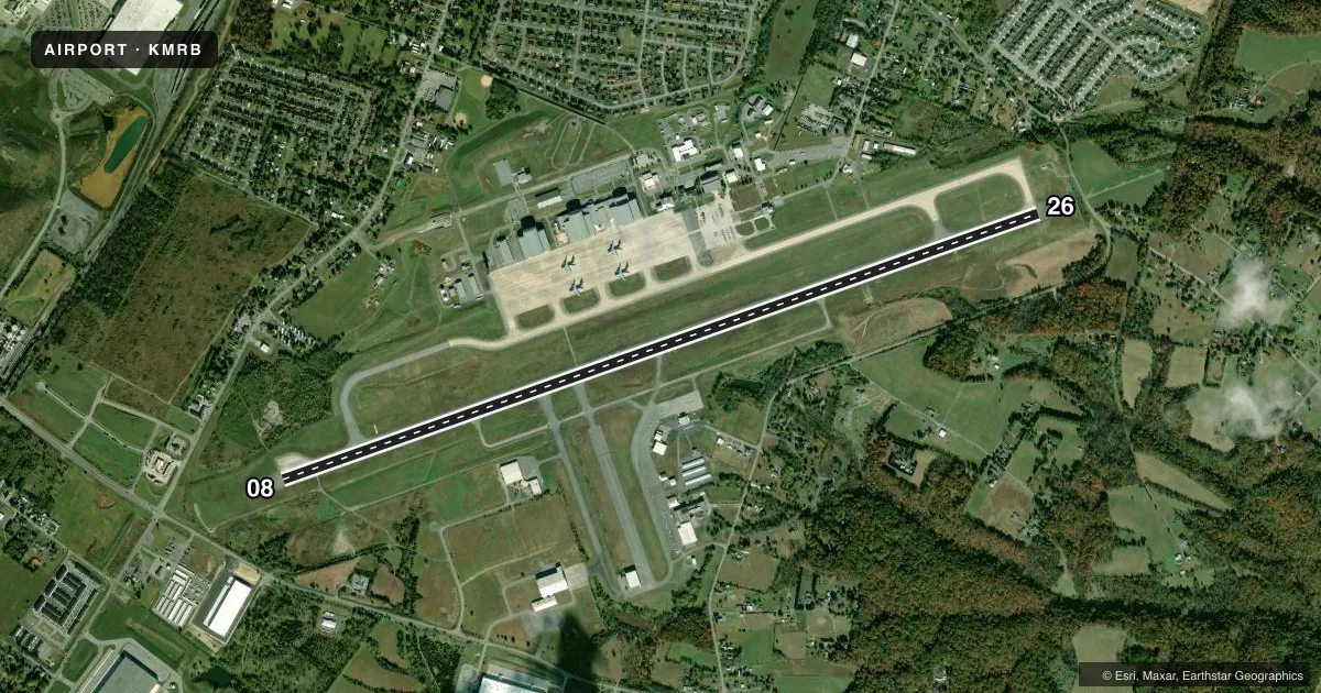
Runways & pattern
Full pagePattern entry · RWY 08
LEFT TRAFFICRunway end performance
| End | TORA | TODA | ASDA | LDA | VGSI | Approach lights | Obstruction |
|---|---|---|---|---|---|---|---|
| 08 | 8,815' | 8,815' | 8,215' | 8,215' | PAPI 4-box left(3°) | — | — |
| 26 | 8,815' | 8,815' | 8,815' | 7,815' | PAPI 4-box left(3°) | MALSR | 64', tree, 768' from thr, 230' R of cntrln, slope 8 |
Declared distances in feet. TORA = takeoff run available, TODA = takeoff distance, ASDA = accelerate-stop, LDA = landing distance.
Airport sketch
Runways drawn to scale from FAA survey coordinates, rendered over satellite imagery. Not for navigation.
Approaches & charts
ILS · 1
Services on the field
Fuel grades, oxygen, maintenance, ramp storage and lighting — as declared to the FAA by the airport operator.
Fuel & services
- Fuel
- 100LLAA++
- Oxygen (bottled)
- High pressure
- Oxygen (bulk)
- Not available
- Airframe repair
- Major
- Power plant repair
- Major
- Other services
- AMB,CHTR,INSTR,RNTL
Ramp & ground
- Transient storage
- Tie-down
- Hangar
- Landing fee
- Yes
- Customs
- Not available
- Lighting schedule
- SEE RMK
- Beacon schedule
- SS-SR
- Beacon
- White / Green (civil land)(WG)
- Wind indicator
- Lighted
- Segmented circle
- Yes
Fuel & FBOs
Cheapest 100LL and Jet A on the field and nearby. Always confirm with the FBO before taxi.
Airport notes
Surface conditions, obstructions, local procedures, lighting outages and other notes published with each FAA cycle.
General notes
- DEER & BIRDS ON & INVOF ARPT.
- TWY B CLSD FM FUEL FARM S.
- MILITARY: ANG: ALL MIL ACFT MUST CTC PIKESIDE (297.9) 20 MIN PRIOR TO LDG AND PRIOR TO ENGINE START. DSN 242-5205, C 304-616-5205. FLT PLANS MAY BE FILED BY EFB OR OTHER FLIGHT PLAN FILING SOFTWARE. SEND TO 167.AW.AIRFIELD.MANAGEMENT@US.AF.MIL.
- ADDNL RWY 08/26 WT BRGS: 2S-175; 2D/D1-568; 2T-585; C5-840.
- TWY D CLSD PAST PVT HGR 1750 FT S OF TWY E.
- FOR CD WHEN ATCT CLSD, CTC POTOMAC APCH ON 132.075 OR IF UNA 866-709-4993.
- FAA ARFF INDEX D/NFPA CAT 8; INDEX E/CAT 10 EQUIP AVBL.
- MILITARY: CAUTION: BASH PHASE II IN EFCT FM 1 OCT TO 30 APR.
- RWY 26 MIL ASSAULT LDG ZONE & PIR MKGS.
- MILITARY: ANG: QUIET HRS 0400-1200Z++MON-FRI, 2100-1300Z++SAT-SUN.
- NO GRASS LANDINGS.
- MILITARY: CSTMS/AG/IMG: CSTMS NOT AVBL, NOT A PORT OF ENTRY.
- MILITARY: MISC: ALL TRAN AIRCREWS SHALL STORE ALL CLASSIFIED MATERIALS UP TO SECRET WITH WG COMD POST.
Lighting notes
- WHEN ATCT CLSD, ACTVT MALSR RWY 26; REIL RWY 08; PAPI RWY 08 & 26; HIRL RWY 08/26 - CTAF.
Fuel notes
- 100LLFULL SVC 0700-1900, AFTER HRS CALL 304-262-2507. 24/7 SELF SVC.
- AFULL SVC 0700-1900, AFTER HRS CALL 304-262-2507.
- A++FULL SVC 0700-1900, AFTER HRS CALL 304-262-2507.
Runway surface & condition
- 08/26SEE GEN RMK FOR ADDNL WT BRGS.
Approach & departure obstructions
- 26APCH RATIO 34:1 AT DTHR.
Other notes
- LDG FEE FOR ACFT GTR THAN 5000 LBS GWT (MIL, FED, STATE, BASED ACFT EXEMPT).
- TPA: RECTANGULAR 1600 FT MSL (1035 FT AGL) LGT AND ROTARY WING ACFT; 2100 FT MSL (1535 FT AGL) FOR HVY ACFT; OVERHEAD 2100 FT MSL (1535 FT AGL).
- 08/26RWY 26 FIRST 590 FT CONC, MIDDLE 7125 FT ASPH, LAST 1100 FT CONC.
VFR map & nearby airports
VFR sectional. Tap any ICAO chip to open that airport.
Key facts · KMRB
Answer card- ICAO
- KMRB
- Name
- EASTERN WV RGNL/SHEPHERD FLD
- Location
- MARTINSBURG, WEST VIRGINIA
- Elevation
- 564.8 ft MSL
- Traffic pattern altitude
- 1,564.8 ft MSL (1,000 AGL)
- Control tower
- Towered · 1200-0400Z++; OT BY NOTAM
- Total runways
- 1
- Longest runway
- 08/26 · 8,815 ft
- Published ILS approaches
- 1
- Published frequencies
- 14
- Magnetic variation
- 8°
- Current flight rules
- VFR
- Current wind
- 000° at 0 kt
- Favored runway now
- –
Eastern WV Rgnl/Shepherd Fld is in Martinsburg, West Virginia. Field elevation is 564.8 ft MSL. The airport has one runway. Runway 08/26 is 8,815 ft long with asphalt and concrete surface sections. The field has a control tower. Published tower hours are 1200-0400Z++ Monday through Friday. Weekend hours are 1300-2100Z++ Saturday and Sunday. Tower service is OT by NOTAM.
Runway 26 has an ILS approach. That is the main precision option on the field. Pattern altitude is not published in the facts block. The published traffic pattern note gives 1,600 ft MSL for light and rotary wing aircraft. Heavy aircraft use 2,100 ft MSL. Overhead is 2,100 ft MSL. Runway 26 is also marked as a military assault landing zone. Taxiway B is closed from the fuel farm south. Plan your taxi carefully.
MRB Aviation is the on-field FBO. It carries 100LL, Jet A and Jet A Prist. 100LL is full service from 0700 to 1900. Self-serve 100LL is available 24 hours a day. Jet A plus plus is full service from 0700 to 1900. Customs is not available. This is not a port of entry. For a first-time arrival, watch the tower hours, the runway 26 military markings and the taxiway closure. Check current procedures before you go.