METAR & TAF KFRR
Current METAR
Observed 16:55Z
KFRR 271655Z AUTO 03003KT 10SM BKN042 BKN050 BKN060 28/19 A2987 RMK AO2 T02770189
- Wind
- 030° @ 3 kt
- Visibility
- 10 SM
- Temp / Dew
- 28°C / 19°C
- Altimeter
- 29.87 inHg
- Clouds
- BKN
- Density alt
- 2,494 ft
- Ceiling
- 4,200 ft AGL
- Rules
- VFR
Airport info & contacts
Manager on record, flight service, ARTCC, attendance schedule and pattern altitude — published by the FAA and refreshed every 28 days.
Location
- From city
- 3 NM W
- VFR sectional
- WASHINGTON
- ARTCC
- ZDC · WASHINGTON
- NOTAM facility
- DCA (NOTAM-D)
Airport manager
- Name
- MIKE BERRY
- Phone
- 540-635-3570
- Address
- 229 STOKES AIRPORT RD, FRONT ROYAL VA 22630
Flight service · Hours
- FSS DCA
- LEESBURG1-800-WX-BRIEF
- Attendance
- MAY-SEP · 0800-1700
- OCT-APR · 0900-1600
Frequencies
Tap any row to copy the frequency to your clipboard.
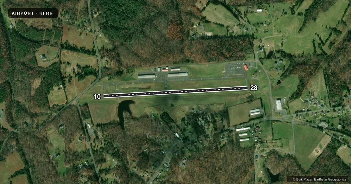
Runways & pattern
Full pagePattern entry · RWY 10
LEFT TRAFFICRunway end performance
| End | TORA | TODA | ASDA | LDA | VGSI | Approach lights | Obstruction |
|---|---|---|---|---|---|---|---|
| 10 | — | — | — | — | PNIR(3°) | — | 24', road, 350' from thr, 131' R of cntrln, slope 6 |
| 28 | — | — | — | — | PNIL(3°) | — | 42', pole, 1382' from thr, 63' R of cntrln, slope 28 |
Declared distances in feet. TORA = takeoff run available, TODA = takeoff distance, ASDA = accelerate-stop, LDA = landing distance.
Airport sketch
Runways drawn to scale from FAA survey coordinates, rendered over satellite imagery. Not for navigation.
Approaches & charts
Services on the field
Fuel grades, oxygen, maintenance, ramp storage and lighting — as declared to the FAA by the airport operator.
Fuel & services
- Fuel
- 100LL
- Oxygen (bottled)
- Not available
- Oxygen (bulk)
- Not available
- Airframe repair
- Minor
- Power plant repair
- Minor
- Other services
- CHTR,GLD,INSTR,PAJA,RNTL,SURV
Ramp & ground
- Transient storage
- Tie-down
- Hangar
- Landing fee
- No fee published
- Customs
- Not available
- Lighting schedule
- SEE RMK
- Beacon schedule
- SS-SR
- Beacon
- White / Green (civil land)(WG)
- Wind indicator
- Lighted
- Segmented circle
- No
Fuel & FBOs
Cheapest 100LL and Jet A on the field and nearby. Always confirm with the FBO before taxi.
Airport notes
Surface conditions, obstructions, local procedures, lighting outages and other notes published with each FAA cycle.
General notes
- GLDR OPS ON & INVOF ARPT.
- NOISE ABATEMENT PROCS IN EFCT, CTC ARPT MGR FOR DTLS AT 540-635-3570.
- DEER & GEESE ON & INVOF ARPT.
- FOR CD CTC POTOMAC APCH AT 866-709-4993.
- PRCHT OPS ON & INVOF ARPT.
Lighting notes
- ACTVT MIRL RWY 10/28 - CTAF.
Approach & departure obstructions
- 10RY 10 RIGHT TFC FOR GYROCOPTERS, ULTRALIGHTS & GLIDERS.
- 28RY 28 RIGHT TFC FOR GYROCOPTERS, ULTRALIGHTS & GLIDERS.
Other notes
- IN OPERATION PRIOR TO 1959
VFR map & nearby airports
VFR sectional. Tap any ICAO chip to open that airport.
Key facts · KFRR
Answer card- ICAO
- KFRR
- Name
- FRONT ROYAL-WARREN COUNTY
- Location
- FRONT ROYAL, VIRGINIA
- Elevation
- 703.6 ft MSL
- Traffic pattern altitude
- 1,703.6 ft MSL (1,000 AGL)
- Control tower
- Non-towered (use CTAF)
- Total runways
- 1
- Longest runway
- 10/28 · 3,008 ft
- Published ILS approaches
- 0
- Published frequencies
- 3
- Magnetic variation
- 10°
- Current flight rules
- VFR
- Current wind
- 030° at 3 kt
- Favored runway now
- RWY 10
Front Royal-Warren County Airport (KFRR) sits in Front Royal, Virginia. Field elevation is 703.6 ft MSL. The airport has one runway. Runway 10/28 is 3,008 ft asphalt, with magnetic headings 87° and 267°. There is no control tower. CTAF and UNICOM are both 123.0. Potomac Approach is on 120.45 for approach and departure services.
No ILS approaches are published here. Pattern altitude is not published, so use the standard 1,000 ft AGL for light piston operations unless the current Chart Supplement or local procedures say otherwise. The on-field FBO is Front Royal-Warren County Airport. It carries 100LL. Call (540) 635-3570 before you go if you need current ramp or fuel details.
Plan for mixed traffic. Deer and geese are reported on and near the field. Parachute operations, glider operations and right traffic for gyrocopters, ultralights and gliders on both runway directions are published. Noise abatement procedures are also in effect. Contact the airport manager for details before arrival. Medium intensity runway lighting on 10/28 is activated by CTAF. For clearance delivery, Potomac Approach can be reached at 866-709-4993.