METAR & TAF 8W2
Current METAR
Observed 13:35Z
K8W2 271335Z AUTO 00000KT 10SM CLR 23/19 A2992 RMK AO1 T02250185
- Wind
- 000° @ 0 kt
- Visibility
- 10 SM
- Temp / Dew
- 23°C / 19°C
- Altimeter
- 29.92 inHg
- Clouds
- CLR
- Density alt
- 2,154 ft
- Ceiling
- Unlimited
- Rules
- VFR
Airport info & contacts
Manager on record, flight service, ARTCC, attendance schedule and pattern altitude — published by the FAA and refreshed every 28 days.
Location
- From city
- 2 NM W
- VFR sectional
- WASHINGTON
- Pattern altitude
- 825 ft AGL · 1,788 ft MSL
- ARTCC
- ZDC · WASHINGTON
- NOTAM facility
- DCA (NOTAM-D)
Airport manager
- Name
- ROBERT THOMAS
- Phone
- 703-327-0444
- Address
- PO BOX 762, MIDDLEBURG VA 20118
Flight service · Hours
- FSS DCA
- LEESBURG1-800-WX-BRIEF
- Attendance
- M-F · 0800 - 1630
Frequencies
Tap any row to copy the frequency to your clipboard.
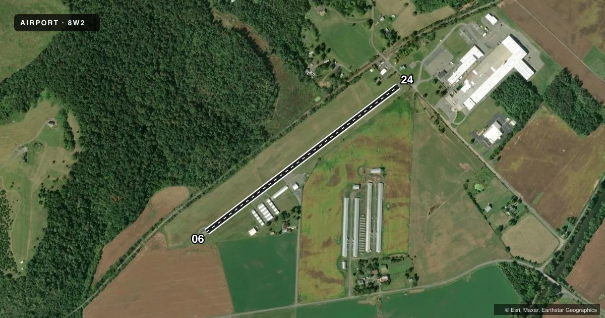
Runways & pattern
Full pagePattern entry · RWY 06
RIGHT TRAFFICRunway end performance
| End | TORA | TODA | ASDA | LDA | VGSI | Approach lights | Obstruction |
|---|---|---|---|---|---|---|---|
| 24 | — | — | — | — | — | — | 15', road, 201' from thr, 100' R of cntrln, slope 0 |
Declared distances in feet. TORA = takeoff run available, TODA = takeoff distance, ASDA = accelerate-stop, LDA = landing distance.
Airport sketch
Runways drawn to scale from FAA survey coordinates, rendered over satellite imagery. Not for navigation.
Approaches & charts
Services on the field
Fuel grades, oxygen, maintenance, ramp storage and lighting — as declared to the FAA by the airport operator.
Fuel & services
- Fuel
- 100LL
- Oxygen (bottled)
- Not available
- Oxygen (bulk)
- Not available
- Airframe repair
- Major
- Power plant repair
- Major
- Other services
- INSTR,PAJA
Ramp & ground
- Transient storage
- Tie-down
- Hangar
- Customs
- Not available
- Lighting schedule
- SS-SR
- Beacon schedule
- SS-SR
- Beacon
- White / Green (civil land)(WG)
- Wind indicator
- Lighted
- Segmented circle
- No
Fuel & FBOs
Cheapest 100LL and Jet A on the field and nearby. Always confirm with the FBO before taxi.
Airport notes
Surface conditions, obstructions, local procedures, lighting outages and other notes published with each FAA cycle.
General notes
- DEER AND BIRDS ON & INVOF RY.
- HOT AIR BALLOONS WEEKENDS EARLY MORNING & LATE AFTERNOON.
- APRXLY 1000 FT N OF RY, 200 FT RIDGE/TREES PARALLEL RY.
- ARRIVING PILOTS SHOULD USE CAUTION. SKYDIVING OPERATIONS WITHIN 2NM OF THE AIRPORT FROM 0800-SUNSET EVERY WEEKEND AND OCCASIONALLY DURING THE WEEK.
- FOR CD CTC WASHINGTON ARTCC AT 703-771-3587.
Fuel notes
- 100LL24 HR CREDIT CARD SVC
Runway surface & condition
- 06/24NSTD LIRL; THLD LGTS ONE FIXTURE EACH SIDE. RY 06 LGTD THLD RELOCATED 100 FT & RY 24 LGTD THLD RELOCATED 930 FT FOR NGT OPNS; 2020 FT RY 06/24 LGTD AT NGT. NO RY END LGTS RY 24.
Approach & departure obstructions
- 24RY 24, 5 FT FENCE 110 FT FM THLD 0B, 15 FT ROAD 115 FT FM THLD 0B, POLE 90 FT FM THR 100 FT R, 23 FT PLINE 114 FT FM THLD 117 FT L.
- 24CTLG OBSTN EXCEEDS 45 DEG SLP; CLNC SLP 34:1 TO DTHR.
- 06RIDGE & TREES PERPINDICULAR TO RWY 06; 225 FT LEFT OF CNTRLN & APRXLY 1300 FT FROM THLD.
Other notes
- BLN RPR STN; ACFT RPRS AVBL, BUT NOT FULL-TIME.
- RT TFC IS USED WHEN LNDG ON RWY 6.
- PWR PLANT RPRS AVBL, BUT NOT FULL-TIME.
- 1UNATNDD THANKSGIVING, CHRISTMAS, AND NEW YEAR'S DAY.
VFR map & nearby airports
VFR sectional. Tap any ICAO chip to open that airport.
Key facts · 8W2
Answer card- ICAO
- 8W2
- Name
- NEW MARKET
- Location
- NEW MARKET, VIRGINIA
- Elevation
- 962.7 ft MSL
- Traffic pattern altitude
- 1,787.7 ft MSL (825 AGL)
- Control tower
- Non-towered (use CTAF)
- Total runways
- 1
- Longest runway
- 06/24 · 2,920 ft
- Published ILS approaches
- 0
- Published frequencies
- 2
- Magnetic variation
- 10°
- Current flight rules
- VFR
- Current wind
- 000° at 0 kt
- Favored runway now
- –
New Market Airport (8W2) sits in New Market, Virginia. Field elevation is 962.7 ft MSL. The airport has one runway. Runway 06/24 is 2,920 ft long and asphalt. There is no control tower. CTAF and UNICOM are both 122.8. Pattern altitude is 825 ft AGL, which is 1,787.7 ft MSL.
No ILS approaches are published here. New Market Aeronautics is on the field. It carries AVGAS 100LL. 24-hour credit card service is published for 100LL fuel. The airport also notes aircraft repairs and power plant repairs are available, but not full-time. Clearance delivery is handled through Washington ARTCC at 703-771-3587.
This is a field where you want to stay sharp on the departure and arrival path. Published remarks call out ridge and trees near runway 06, plus a 34:1 clearance slope to the departure threshold on runway 24. There are also deer and birds in the area. Skydiving operations occur within 2 NM of the airport from 0800 to sunset every weekend, with occasional weekday activity. Hot air balloons also operate on weekends in the early morning and late afternoon. Check the current FAA Chart Supplement and coordinate with the airport operator before you go if you need the latest operational picture.