METAR & TAF KVBW
Current METAR
Observed 13:35Z
KVBW 271335Z AUTO 00000KT 10SM CLR 22/19 A2993 RMK AO1 T02230185
- Wind
- 000° @ 0 kt
- Visibility
- 10 SM
- Temp / Dew
- 22°C / 19°C
- Altimeter
- 29.93 inHg
- Clouds
- CLR
- Density alt
- 2,272 ft
- Ceiling
- Unlimited
- Rules
- VFR
Airport info & contacts
Manager on record, flight service, ARTCC, attendance schedule and pattern altitude — published by the FAA and refreshed every 28 days.
Location
- From city
- 1 NM SE
- VFR sectional
- WASHINGTON
- ARTCC
- ZDC · WASHINGTON
- NOTAM facility
- DCA (NOTAM-D)
Airport manager
- Name
- AARON LORSON
- Phone
- 540-828-6070
- Address
- PO BOX 7, BRIDGEWATER VA 22812
Flight service · Hours
- FSS DCA
- LEESBURG1-800-WX-BRIEF
- Attendance
- MON-FRI · 0800-1700
- SAT · 0900-1600
- SUN · 1200-1600
Frequencies
Tap any row to copy the frequency to your clipboard.
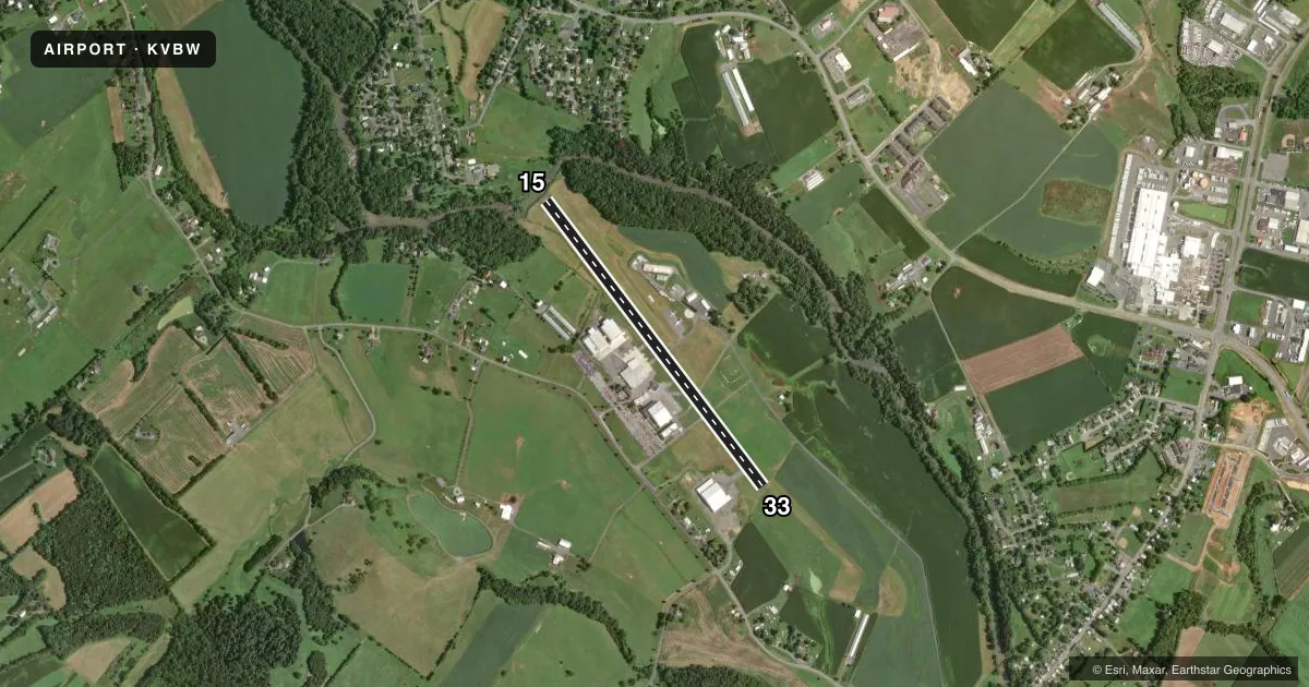
Runways & pattern
Full pagePattern entry · RWY 15
LEFT TRAFFICRunway end performance
| End | TORA | TODA | ASDA | LDA | VGSI | Approach lights | Obstruction |
|---|---|---|---|---|---|---|---|
| 15 | — | — | — | — | — | — | 11', tree, 298' from thr, 207' R of cntrln, slope 8 |
| 33 | — | — | — | — | — | — | 1', fence, 207' from thr, 50' R of cntrln, slope 7 |
Declared distances in feet. TORA = takeoff run available, TODA = takeoff distance, ASDA = accelerate-stop, LDA = landing distance.
Airport sketch
Runways drawn to scale from FAA survey coordinates, rendered over satellite imagery. Not for navigation.
Approaches & charts
Services on the field
Fuel grades, oxygen, maintenance, ramp storage and lighting — as declared to the FAA by the airport operator.
Fuel & services
- Fuel
- A+
Ramp & ground
- Transient storage
- Tie-down
- Landing fee
- No fee published
- Lighting schedule
- SEE RMK
- Beacon schedule
- SS-SR
- Beacon
- White / Green (civil land)(WG)
- Wind indicator
- Yes
- Segmented circle
- No
Fuel & FBOs
Cheapest 100LL and Jet A on the field and nearby. Always confirm with the FBO before taxi.
Airport notes
Surface conditions, obstructions, local procedures, lighting outages and other notes published with each FAA cycle.
General notes
- FOR CD CTC POTOMAC APCH AT 866-640-4124.
Lighting notes
- ACTVT MIRL RWY 15/33 - CTAF.
Approach & departure obstructions
- 33RWY 33 2 FT FENCE POST 70 FT FM THR, 27FT R OF CNTRLN.
Other notes
- EXISTED PRIOR TO 1959.
VFR map & nearby airports
VFR sectional. Tap any ICAO chip to open that airport.
Key facts · KVBW
Answer card- ICAO
- KVBW
- Name
- BRIDGEWATER AIR PARK
- Location
- BRIDGEWATER, VIRGINIA
- Elevation
- 1,165 ft MSL
- Traffic pattern altitude
- 2,165 ft MSL (1,000 AGL)
- Control tower
- Non-towered (use CTAF)
- Total runways
- 1
- Longest runway
- 15/33 · 4,034 ft
- Published ILS approaches
- 0
- Published frequencies
- 4
- Magnetic variation
- 9°
- Current flight rules
- VFR
- Current wind
- 000° at 0 kt
- Favored runway now
- –
Bridgewater Air Park is in Bridgewater, Virginia. The field elevation is 1,165 ft MSL. It has one runway, 15/33, which is 4,034 ft long and asphalt. There is no control tower. Potomac Approach handles the area. Clearance delivery is through Potomac Approach at 866-640-4124.
No ILS approaches are published here. The runway lights on 15/33 are medium intensity and are activated by the CTAF. The published pattern altitude is not listed, so use the standard 1,000 ft AGL for light piston operations unless the current Chart Supplement says otherwise. That puts the pattern at 2,165 ft MSL based on field elevation.
Plan for the published obstruction near runway 33. There is a 2-foot fence post 70 feet from the threshold, 27 feet right of centerline. That is a small item. It is worth keeping in mind on short final. The airport also has no on-field FBO listed, so call the airport operator or the FBO directly before arrival if you need current fuel or service details. This is a non-towered field, so expect self-announce traffic on CTAF 122.7. Check the current Chart Supplement for any published local procedures before you go.