METAR & TAF KGVE
Current METAR
Observed 19:35Z
KGVE 261935Z AUTO 29003KT 10SM SCT070 30/17 A2986 RMK AO1 T02980165
- Wind
- 290° @ 3 kt
- Visibility
- 10 SM
- Temp / Dew
- 30°C / 17°C
- Altimeter
- 29.86 inHg
- Clouds
- SCT
- Density alt
- 2,435 ft
- Ceiling
- Unlimited
- Rules
- VFR
Airport info & contacts
Manager on record, flight service, ARTCC, attendance schedule and pattern altitude — published by the FAA and refreshed every 28 days.
Location
- From city
- 2 NM NE
- VFR sectional
- WASHINGTON
- ARTCC
- ZDC · WASHINGTON
- NOTAM facility
- DCA (NOTAM-D)
Airport manager
- Name
- DEBORAH S. KENDALL, TOWN MGR
- Phone
- (540) 832-2233
- Address
- PO BOX 276, GORDONSVILLE VA 22942
Flight service · Hours
- FSS DCA
- LEESBURG1-800-WX-BRIEF
- Attendance
- Unattended
Frequencies
Tap any row to copy the frequency to your clipboard.
Runways & pattern
Full pagePattern entry · RWY 23
LEFT TRAFFICRunway end performance
| End | TORA | TODA | ASDA | LDA | VGSI | Approach lights | Obstruction |
|---|---|---|---|---|---|---|---|
| 05 | — | — | — | — | PNIR | — | 11', tree, 217' from thr, 46' R of cntrln, slope 1 |
| 23 | — | — | — | — | PNIR | — | 77', tree, 567' from thr, 130' R of cntrln, slope 4 |
Declared distances in feet. TORA = takeoff run available, TODA = takeoff distance, ASDA = accelerate-stop, LDA = landing distance.
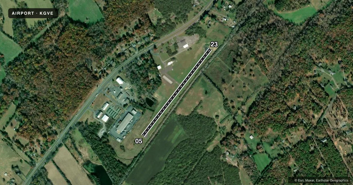
Airport sketch
Runways drawn to scale from FAA survey coordinates, rendered over satellite imagery. Not for navigation.
Approaches & charts
Services on the field
Fuel grades, oxygen, maintenance, ramp storage and lighting — as declared to the FAA by the airport operator.
Fuel & services
- Fuel
- Not available
- Oxygen (bottled)
- Not available
- Oxygen (bulk)
- Not available
- Airframe repair
- Not available
- Power plant repair
- Not available
Ramp & ground
- Transient storage
- Tie-down
- Landing fee
- No fee published
- Lighting schedule
- SEE RMK
- Beacon schedule
- SS-SR
- Beacon
- White / Green (civil land)(WG)
- Wind indicator
- Lighted
- Segmented circle
- No
Fuel & FBOs
Cheapest 100LL and Jet A on the field and nearby. Always confirm with the FBO before taxi.
Airport notes
Surface conditions, obstructions, local procedures, lighting outages and other notes published with each FAA cycle.
General notes
- FOR CD CTC POTOMAC APCH AT 866-640-4124.
Lighting notes
- ACTVT MIRL RWY 05/23 - CTAF.
Approach & departure obstructions
- 23LINE OF TREES 120 FT S OF RWY CNTRLN.
VFR map & nearby airports
VFR sectional. Tap any ICAO chip to open that airport.
Key facts · KGVE
Answer card- ICAO
- KGVE
- Name
- GORDONSVILLE MUNI
- Location
- GORDONSVILLE, VIRGINIA
- Elevation
- 452 ft MSL
- Traffic pattern altitude
- 1,452 ft MSL (1,000 AGL)
- Control tower
- Non-towered (use CTAF)
- Total runways
- 1
- Longest runway
- 05/23 · 2,300 ft
- Published ILS approaches
- 0
- Published frequencies
- 4
- Magnetic variation
- 10°
- Current flight rules
- VFR
- Current wind
- 290° at 3 kt
- Favored runway now
- RWY 23
Gordonsville Muni sits in Gordonsville, Virginia. Field elevation is 452 ft MSL. The airport has one runway, 05/23, which is 2,300 ft long and asphalt. There is no control tower. No ILS approaches are published. Pattern altitude is not published, so use the standard 1,000 ft AGL for light piston traffic unless the current Chart Supplement says otherwise.
This is a non-towered field with CTAF and UNICOM both on 123.0. Potomac Approach is listed on 132.85 and 323.125 for approach and departure work. The published remarks also note a line of trees 120 feet south of the runway centerline near the runway 23 end. That is worth keeping in mind on short final and during go-around planning. Medium intensity runway lights on 05/23 are pilot-controlled through the CTAF. That helps for night arrivals.
No on-field FBOs are listed in the facts, so verify current services with the airport operator or call the field on CTAF/UNICOM before arrival. For a first visit, treat it as a small non-towered airport with one short asphalt runway. Check the current Chart Supplement for any noise or curfew restrictions before flying in.