METAR & TAF KEZF
Current METAR
Observed 11:55Z
KEZF 271155Z AUTO 00000KT 10SM BKN100 A2987 RMK AO2 60007 70007
- Wind
- 000° @ 0 kt
- Visibility
- 10 SM
- Temp / Dew
- —
- Altimeter
- 29.87 inHg
- Clouds
- BKN
- Density alt
- —
- Ceiling
- 10,000 ft AGL
- Rules
- VFR
Airport info & contacts
Manager on record, flight service, ARTCC, attendance schedule and pattern altitude — published by the FAA and refreshed every 28 days.
Location
- From city
- 2 NM S
- VFR sectional
- WASHINGTON
- ARTCC
- ZDC · WASHINGTON
- NOTAM facility
- EZF (NOTAM-D)
Airport manager
- Name
- SHANNON AIRPORT LLC
- Phone
- 540-373-4431
- Address
- 3380 SHANNON AIRPORT CIRCLE, FREDERICKSBURG VA 22408
Flight service · Hours
- FSS DCA
- LEESBURG1-800-WX-BRIEF
- Attendance
- 0800-1700
Frequencies
Tap any row to copy the frequency to your clipboard.
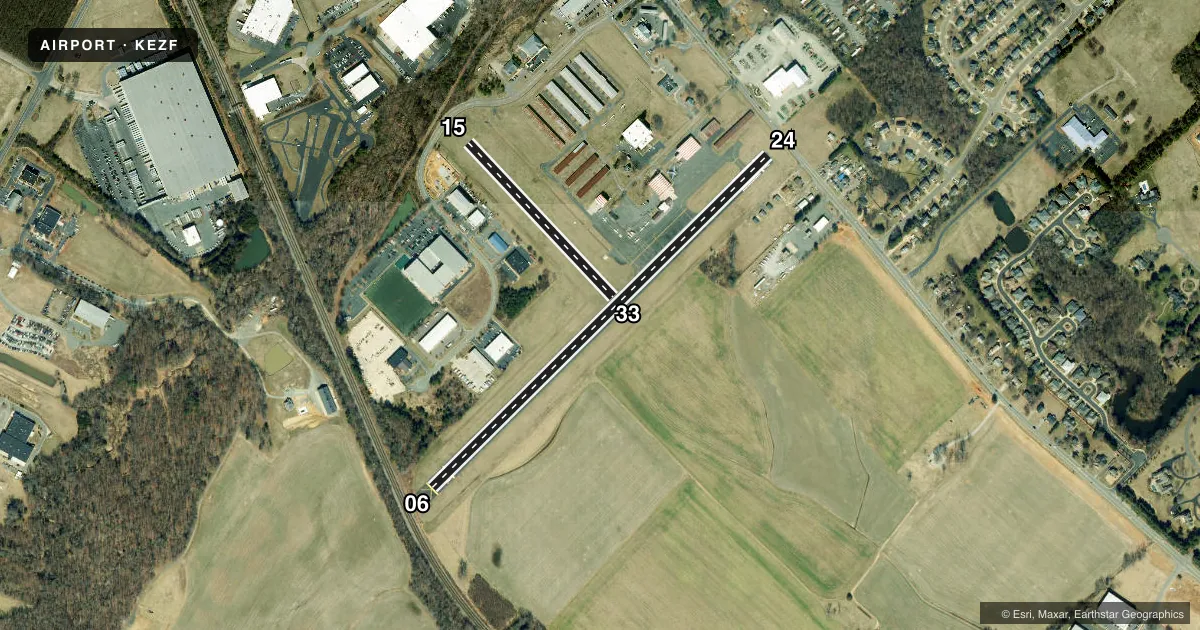
Runways & pattern
Full pagePattern entry · RWY 06
LEFT TRAFFIC| Runway | Heading (°M) | Length | Surface | Traffic |
|---|---|---|---|---|
| 06/24 | 35° / 215° | 2,902 ft | ASPH | Standard L |
| 15/33 | 127° / 307° | 1,300 ft | TURF | Standard L |
Runway end performance
| End | TORA | TODA | ASDA | LDA | VGSI | Approach lights | Obstruction |
|---|---|---|---|---|---|---|---|
| 06 | — | — | — | — | PSIL | — | 23', rr, 205' from thr, 0' R of cntrln, slope 1 |
| 24 | — | — | — | — | PSIL | — | 40', tree, 450' from thr, 117' R of cntrln, slope 6 |
| 15 | — | — | — | — | — | — | 43', brush, 235' from thr, 121' R of cntrln, slope 5 |
Declared distances in feet. TORA = takeoff run available, TODA = takeoff distance, ASDA = accelerate-stop, LDA = landing distance.
Airport sketch
Runways drawn to scale from FAA survey coordinates, rendered over satellite imagery. Not for navigation.
Approaches & charts
Services on the field
Fuel grades, oxygen, maintenance, ramp storage and lighting — as declared to the FAA by the airport operator.
Fuel & services
- Fuel
- 100LLA+
- Oxygen (bottled)
- Not available
- Oxygen (bulk)
- Not available
- Airframe repair
- Major
- Power plant repair
- Major
- Other services
- AMB,INSTR,RNTL
Ramp & ground
- Transient storage
- Tie-down
- Hangar
- Landing fee
- No fee published
- Customs
- Not available
- Lighting schedule
- SEE RMK
- Beacon schedule
- SS-SR
- Beacon
- White / Green (civil land)(WG)
- Wind indicator
- Lighted
- Segmented circle
- No
Fuel & FBOs
Cheapest 100LL and Jet A on the field and nearby. Always confirm with the FBO before taxi.
Airport notes
Surface conditions, obstructions, local procedures, lighting outages and other notes published with each FAA cycle.
General notes
- RWY 15 CLSD TO LNDG.
- CLEARANCE DELIVERY PHONE: GCO AVBL ON FREQ 135.075; QUANTICO CD DURING OP HRS - 6 CLICKS, POTOMAC CD ALL OTR TIMES - 4 CLICKS. IF UNA, FOR CD CTC QUANTICO CD DURING OP HOURS AT 703-784-5990, POTOMAC APCH ALL OTR TIMES AT 866-709-4993.
- 24 HR SELF-SVC AVBL, FUEL TRUCK AVBL DURG OPR HRS.
- 15 FT ROAD, 188 FT FM THR, BOTH SIDES CNTRLN.
- RWY 33 CLSD DLY SS-SR.
- APCHS TO RWY 6/24 WILL BE MADE SUFLY HIGH TO CROSS RT. 2 (RWY 24) OR THE RAILROAD TRACKS (RWY 6) AT OR ABV 135 FT MSL (50 FT AGL).
- TRAN ACFT PARK ON RAMP NE SIDE OF TRML.
- REQ R/W ACFT NOT TAXI NEXT TO TRML.
- RWY 15 APCH N/A, RWY 33 CLSD FOR TKOF.
Lighting notes
- ACTVT MIRL RWY 06/24 - CTAF.
Approach & departure obstructions
- 06+20 FT TRR 180-200 FT FM RWY END 143 FT L TO 145 R.
- 2412 FT ROAD 126 FT FM RWY END 2 FT L.
- 06FIRST 89 FT PAVEMENT RWY 06 MARKED AS UNUSBL.
- 1515/33 OUTLINED WITH YELLOW CONES.
- 06RWY 06 PVASI OTS INDEFLY.
- 06RWY 06 +21 FT RR, DIST 348 FT, 16:1 BASED ON DSPLCD THLD.
- 15CTLG OBSTN EXCEEDS A 45 DEG SLP.
- 24RWY 24, 12 FT ROAD, 206 FT, 2 FT L, 0:1 BASED ON DSPLCD THR.
Other notes
- PRIOR TO 1959.
- 1UNATNDD NEW YEAR'S, EASTER, INDEPENDENCE, THANKSGIVING, & CHRISTMAS DAYS.
VFR map & nearby airports
VFR sectional. Tap any ICAO chip to open that airport.
Key facts · KEZF
Answer card- ICAO
- KEZF
- Name
- SHANNON
- Location
- FREDERICKSBURG, VIRGINIA
- Elevation
- 85 ft MSL
- Traffic pattern altitude
- 1,085 ft MSL (1,000 AGL)
- Control tower
- Non-towered (use CTAF)
- Total runways
- 2
- Longest runway
- 06/24 · 2,902 ft
- Published ILS approaches
- 0
- Published frequencies
- 6
- Magnetic variation
- 10°
- Current flight rules
- VFR
- Current wind
- 000° at 0 kt
- Favored runway now
- –
Shannon Airport sits in Fredericksburg, Virginia. Field elevation is 85 ft MSL. The airport has two runways. The longest is 06/24 at 2,902 ft on asphalt. Runway 15/33 is 1,300 ft on turf. There is no control tower. CTAF and UNICOM are both 122.8. No ILS approaches are published here.
Pattern altitude is not published. Use the standard 1,000 ft AGL for light piston traffic unless the current Chart Supplement says otherwise. Shannon Airport is served by Shannon Airport on the field. It carries AVGAS 100LL and Jet A Prist. Call (540) 373-4431 for current service details before you go.
A few runway notes matter here. Runway 33 is closed from sunset to sunrise. Runway 33 is also closed for takeoff. Runway 15 is not available for approach. Runway 06 has a PAPI out of service indefinitely. There is also a railroad obstruction near Runway 06, plus a road close to both sides of the centerline. Approaches to 06/24 are expected to stay high enough to cross Route 2 near Runway 24 or the railroad near Runway 6 at or above 135 ft MSL. If you are new to the field, brief the runway 06/24 lighting and obstruction picture before arrival.