METAR & TAF 2W5
2W5 does not publish a METAR.
Showing the nearest reporting station: KDCA (RONALD REAGAN WASHINGTON NTL) · 15.4 NM away. Conditions at 2W5 may differ.
METAR · KDCA
Observed 11:52Z
KDCA 271152Z VRB03KT 10SM FEW075 FEW250 24/19 A2986 RMK AO2 SLP109 T02390194 10239 20222 51011
- Wind
- VAR @ 3 kt
- Visibility
- 10 SM
- Temp / Dew
- 24°C / 19°C
- Altimeter
- 29.86 inHg
- Clouds
- FEW
- Density alt
- 1,371 ft
- Ceiling
- Unlimited
- Rules
- VFR
Airport info & contacts
Manager on record, flight service, ARTCC, attendance schedule and pattern altitude — published by the FAA and refreshed every 28 days.
Location
- From city
- 4 NM E
- VFR sectional
- WASHINGTON
- Pattern altitude
- 830 ft AGL · 1,005 ft MSL
- ARTCC
- ZDC · WASHINGTON
- NOTAM facility
- DCA (NOTAM-D)
Airport manager
- Name
- SHEEL PATEL
- Phone
- 301-283-6202
- Address
- 3900 LIVINGSTON RD, INDIAN HEAD MD 20640
Flight service · Hours
- FSS DCA
- LEESBURG1-800-WX-BRIEF
- Attendance
- MON-SUN · 0900-1800
Frequencies
Tap any row to copy the frequency to your clipboard.
Runways & pattern
Full pagePattern entry · RWY 02
LEFT TRAFFICRunway end performance
| End | TORA | TODA | ASDA | LDA | VGSI | Approach lights | Obstruction |
|---|---|---|---|---|---|---|---|
| 02 | — | — | — | — | PAPI 4-box left(3°) | — | 85', trees, 2236' from thr, 195' R of cntrln, slope 23 |
| 20 | — | — | — | — | — | — | 67', trees, 1712' from thr, 240' R of cntrln, slope 22 |
Declared distances in feet. TORA = takeoff run available, TODA = takeoff distance, ASDA = accelerate-stop, LDA = landing distance.
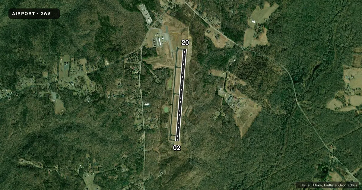
Airport sketch
Runways drawn to scale from FAA survey coordinates, rendered over satellite imagery. Not for navigation.
Approaches & charts
Services on the field
Fuel grades, oxygen, maintenance, ramp storage and lighting — as declared to the FAA by the airport operator.
Fuel & services
- Fuel
- 100LLA
- Oxygen (bottled)
- Not available
- Oxygen (bulk)
- Not available
- Airframe repair
- Minor
- Power plant repair
- Minor
- Other services
- AVNCS,INSTR
Ramp & ground
- Transient storage
- Tie-down
- Landing fee
- No fee published
- Customs
- Not available
- Lighting schedule
- SEE RMK
- Beacon schedule
- SS-SR
- Beacon
- White / Green (civil land)(WG)
- Wind indicator
- Yes
- Segmented circle
- No
Fuel & FBOs
Cheapest 100LL and Jet A on the field and nearby. Always confirm with the FBO before taxi.
Airport notes
Surface conditions, obstructions, local procedures, lighting outages and other notes published with each FAA cycle.
General notes
- BIRDS & WILDLIFE ON & INVOF ARPT.
- FOR CD CTC POTOMAC APCH AT 866-599-3874.
Lighting notes
- ACTVT REIL RWY 02; PAPI RWY 02; MIRL RWY 02/20 - CTAF. ARPT DEACTIVATES PAPI RWY 02 WHEN WINDS FAVOR RWY 20.
Other notes
- ESTAB PRIOR TO 1959.
- 2UNATNDD THANKSGIVING, CHRISTMAS AND NEW YEARS DAYS.
- INSTRAME AVBL BY APPOINTMENT.
VFR map & nearby airports
VFR sectional. Tap any ICAO chip to open that airport.
Key facts · 2W5
Answer card- ICAO
- 2W5
- Name
- MARYLAND
- Location
- INDIAN HEAD, MARYLAND
- Elevation
- 175 ft MSL
- Traffic pattern altitude
- 1,005 ft MSL (830 AGL)
- Control tower
- Non-towered (use CTAF)
- Total runways
- 1
- Longest runway
- 02/20 · 3,740 ft
- Published ILS approaches
- 0
- Published frequencies
- 6
- Magnetic variation
- 9°
- Current flight rules
- VFR
- Current wind
- 000° at 3 kt
- Favored runway now
- RWY 02
Maryland Airport (2W5) sits in Indian Head, Maryland. The field elevation is 175 ft MSL. It has one runway. Runway 02/20 is 3,740 ft long with an asphalt surface. The airport is non-towered. Pattern altitude is 830 ft AGL, which is 1,005 ft MSL.
No ILS approaches are published here. For clearance delivery, Potomac Approach handles it at 866-599-3874. The published approach frequencies are all Potomac sectors. Plan to work the area carefully. Verify the current Chart Supplement before you go. Runway lighting is pilot-controlled on CTAF. Runway end identifier lights are on runway 02. A PAPI is available on runway 02. The airport turns that PAPI off on runway 02 when winds favor runway 20.
PSM Aviation is on the field. It carries 100LL and Jet A. The airport can see birds and wildlife on and near the field. Keep that in mind on departure and in the pattern. The airport was established before 1959. It is unattended on Thanksgiving, Christmas and New Year's Day. For a first visit, expect a small field with Potomac-area traffic flow, a single runway and no tower to sort things out for you.