METAR & TAF KHWY
Current METAR
Observed 15:55Z
KHWY 271555Z AUTO 34007KT 10SM CLR 29/17 A2988 RMK AO2 T02870166
- Wind
- 340° @ 7 kt
- Visibility
- 10 SM
- Temp / Dew
- 29°C / 17°C
- Altimeter
- 29.88 inHg
- Clouds
- CLR
- Density alt
- 2,146 ft
- Ceiling
- Unlimited
- Rules
- VFR
Airport info & contacts
Manager on record, flight service, ARTCC, attendance schedule and pattern altitude — published by the FAA and refreshed every 28 days.
Location
- From city
- 12 NM SE
- VFR sectional
- WASHINGTON
- ARTCC
- ZDC · WASHINGTON
- NOTAM facility
- DCA (NOTAM-D)
Airport manager
- Name
- STACEY WILLIAMS
- Phone
- 540-422-8284
- Address
- 1533 IRIS TRAIL, PO BOX 198, MIDLAND VA 22728-0068
Flight service · Hours
- FSS DCA
- LEESBURG1-800-WX-BRIEF
- Attendance
- 0800-DARK
Frequencies
Tap any row to copy the frequency to your clipboard.
Runways & pattern
Full pagePattern entry · RWY 33
LEFT TRAFFICRunway end performance
| End | TORA | TODA | ASDA | LDA | VGSI | Approach lights | Obstruction |
|---|---|---|---|---|---|---|---|
| 15 | — | — | — | — | PAPI 4-box left(3°) | — | 87', tree, 2398' from thr, 756' R of cntrln, slope 25 |
| 33 | — | — | — | — | PAPI 4-box left(3°) | — | 92', tree, 3187' from thr, 268' R of cntrln, slope 32 |
Declared distances in feet. TORA = takeoff run available, TODA = takeoff distance, ASDA = accelerate-stop, LDA = landing distance.
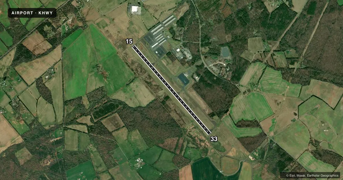
Airport sketch
Runways drawn to scale from FAA survey coordinates, rendered over satellite imagery. Not for navigation.
Approaches & charts
ILS · 1
Services on the field
Fuel grades, oxygen, maintenance, ramp storage and lighting — as declared to the FAA by the airport operator.
Fuel & services
- Fuel
- 100LLA
- Oxygen (bottled)
- Not available
- Oxygen (bulk)
- Not available
- Airframe repair
- Major
- Power plant repair
- Major
- Other services
- CHTR,INSTR,RNTL
Ramp & ground
- Transient storage
- Tie-down
- Hangar
- Landing fee
- No fee published
- Customs
- Not available
- Lighting schedule
- SEE RMK
- Beacon schedule
- SS-SR
- Beacon
- White / Green (civil land)(WG)
- Wind indicator
- Lighted
- Segmented circle
- Yes
Fuel & FBOs
Cheapest 100LL and Jet A on the field and nearby. Always confirm with the FBO before taxi.
Airport notes
Surface conditions, obstructions, local procedures, lighting outages and other notes published with each FAA cycle.
General notes
- ULTRALIGHT ACTIVITY ON & INVOF ARPT.
- AEROBATIC ACTIVITY ADJACENT TO WEST SIDE OF RWY 15/33.
- AEROBATIC DEMO AREA WITHIN 2 NM SOUTH OF ARPT 3500 FT & BLW; 1000-2200; MAY - OCT.
- FOR CD CTC POTOMAC APCH AT 866-709-4993.
- NOISE ABATEMENT PROCS IN EFCT OVER TOWN OF MIDLAND; CTC AMGR.
- RWY 15 PREF CALM WIND RWY.
Lighting notes
- ACTVT HIRL RWY 15/33 - CTAF.
VFR map & nearby airports
VFR sectional. Tap any ICAO chip to open that airport.
Key facts · KHWY
Answer card- ICAO
- KHWY
- Name
- WARRENTON/FAUQUIER
- Location
- WARRENTON, VIRGINIA
- Elevation
- 336.2 ft MSL
- Traffic pattern altitude
- 1,336.2 ft MSL (1,000 AGL)
- Control tower
- Non-towered (use CTAF)
- Total runways
- 1
- Longest runway
- 15/33 · 5,000 ft
- Published ILS approaches
- 1
- Published frequencies
- 4
- Magnetic variation
- 10°
- Current flight rules
- VFR
- Current wind
- 340° at 7 kt
- Favored runway now
- RWY 33
Warrenton/Fauquier Airport sits in Warrenton, Virginia. Field elevation is 336.2 ft MSL. The airport has one runway. Runway 15/33 is 5,000 ft of asphalt, which is the longest runway on the field. There is no control tower. CTAF and UNICOM are both 122.7. Potomac Approach handles approach and departure work on 128.525 and 306.925. For clearance delivery, contact Potomac Approach. The field has one ILS approach to runway 15.
Pattern altitude is not published. Use standard 1,000 ft AGL for light piston traffic unless current local guidance says otherwise. The runway headings are 139° and 319° magnetic. Runway 15 is the preferred calm wind runway. High intensity runway lighting on 15/33 is activated by the common traffic advisory frequency.
Warrenton-Fauquier Airport has one on-field FBO. Warrenton-Fauquier Airport carries 100LL, Jet A and Jet A Prist. The FBO phone is (540) 422-8285. Noise abatement procedures are in effect over the town of Midland. Ultralight activity is on and in the vicinity of the airport. There is also aerobatic activity adjacent to the west side of runway 15/33. From May through October, an aerobatic demonstration area operates within 2 NM south of the airport from 3,500 ft and below between 1000 and 2200. A first-time pilot should brief the local traffic picture before arrival. Be ready for mixed activity near the pattern.